# 👨🏻✈️ VFR in Finland
[](https://wiki.vatsim-scandinavia.org/uploads/images/gallery/2025-05/vfr-fi.png)
## Weather minima
The minimum weather conditions where an aircraft can fly under Visual Flight Rules is described in the table below.
Airspace class
Minimum visibility
Minimum cloud ceiling
D (Control Zone)
5 km
BKN or OVC 1000 ft
For **Special VFR**, the minima may be reduced to:
D (Control Zone)
1500 m
BKN or OVC 600 ft
- All Control Zones in Finland are `D` airspace
- Check [ilmailusaa.fi](https://ilmailusaa.fi/) for weather information
On VATSIM you can fly as VFR also in IMC conditions. It is recommended to add `RMK/SIMULATED VMC` to the flight plan.
- **VMC**: Visual Meteorological Conditions - weather conditions that allow pilots to fly using visual references
- **IMC**: Instrument Meteorological Conditions - pilots must rely on flight instruments for navigation due to low visibility
## Charts
- [eAIP Finland](https://www.ais.fi/eaip/)
- From the left menu, navigate to `AD 2` for controlled aerodromes
- VAC charts are the most useful ones for VFR flying
- [lentopaikat.fi](https://lentopaikat.fi/)
- Information about uncontrolled aerodromes
- [flyk.com](https://flyk.com/map) or [Fintraffic Sky](https://sky.fintraffic.fi/)
- Interactive maps with airspace and weather information
- [Local TRA Charts](https://www.ais.fi/localtra/localtra.htm)
- Local Training Areas around airports (in CTR and TMA)
Charts provide the pilots essential information for the flight such as:
- Traffic circuit direction and altitude
- Visual Reporting Points
- Airspace structure, vertical limits, holding areas
- landmarks for visual navigation
- Apron locations, ground layout
## Flight Plan
### Origin and Destination
Use the ICAO four-letter code e.g. `EFOU` in the departure and destination fields. If the aerodrome does not have a code, use `ZZZZ` and specify the aerodrome location in the REMARK field e.g. `DEP/KORVATUNTURI` or `DEST/601542N0193819E`.
If the flight plan is given in flight, insert `AFIL` in the departure field. The location of the ATS-unit from which supplementary flight plan data can be obtained shall be marked to the Remarks field, e.g. `DEP/EFRO` for Rovaniemi TWR/APP.
### Route Field
The entries below can be used in the Flight Plan Route field
ROUTE Field
Explanation
OULU CTR
Flight staying within the Control Zone
LOIMAA FORSSA
Aerodrome or destination location in plain language
TC
Traffic Circuit. You may specify the type and amount of landings in the REMARK field, e.g. `RMK/2TGL 1SL 1FS`
TA
Training Area. If you request a certain area, you may insert the name to the REMARK field e.g. `RMK/TRAJY04`. Check [V-LARA Airspace Reservation](https://wiki.vatsim-scandinavia.org/books/finnish-airports-charts/page/v-lara-airspace-reservation) if you wish to reserve an airspace block.
LINTU
Visual Reporting Points used when entering or exiting the Control Zone. Pilots should plan the flights via the VRP's as they are establihsed for noise abatement.
### Remarks Field
The following entries can be used in the Flight Plan Remarks field (`RMK/...`)
RMK/
Explanation
FS
Full Stop Landing
LA
Low Approach
TGL
Touch and Go Landing
SL
Spot Landing
PFL
Practiced Forced Landing
PFLR
Practiced Forced Landing back to Runway
VFR ON TOP
For a VFR flight to be operated on top of clouds
DEP EFOU
Activating VFR flight plan shall be done by radio to the ATS unit whose area of responsibility the aerodrome is located
ARR EFTP
Closing VFR flight plan shall be done by radio to the ATS unit whose area of responsibility the aerodrome is located
DEP EFIN
Flight plan activation or closure is intended to be given to the EFIN ACC by radio
DEP ARR EFRO
Flight plan activation and closure is intended to Rovaniemi ATS by radio
FPL CLOSING KUKSA EFRO
Flight plan closing at the boundary of controlled airspace
## Abbreviated Call Sign
When using abbreviated call signs, the first and at least the last two characters of the aircraft registration are used.
Example: The call sign `OH-ABC` is abbreviated as `O-BC` ("Oscar Bravo Charlie") or `O-ABC` ("Oscar Alpha Bravo Charlie").
Abbreviated call signs should be used only after radio contact has been established and provided that there is no risk of confusion. **The aircraft may use an abbreviated call sign only after the ground station (ATC) has used it**.
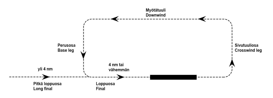
## Local Traffic Circuit
Local Traffic Circuit is a standardised flight path in the immediate vicinity of an aerodrome used mainly by General Aviation VFR flights.
Every controlled aerodrome has its own **Visual Approach Chart (VAC)** which includes essential information for flights in the Control Zone. Before your flight, you need to have a general understanding of the traffic circuit legs illustrated below:
[](https://wiki.vatsim-scandinavia.org/uploads/images/gallery/2023-05/5e24070d078966540b0021e25eaaccea.png)
Always use left turns unless otherwise instructed by ATC.
Pilots shall always report when on downwind, e.g. `O-ME, DOWNWIND RUNWAY 30, TOUCH AND GO`. If no clearance has been received, pilots shall also report when established on the final leg.
Long final is when the aircraft is over 4 miles away from the runway threshold. The `ON LONG FINAL` call is made on 8 miles final.
### Flight Plan Example
```
(FPL-OHCME-VG
-C172/L-FOV/C
-EFOU0730
-N0100A013 TC
-EFOU0100
-DOF/250516 RMK/2TGL 1SL 1FS)
```
In the example above, the pilot will perform 2 touch-and-go landings, 1 spot-landing and 1 full-stop-landing.
### Phraseology Example
👨🏻✈️
OULU TOWER, OH-CME OULUN TORNI, OH-CME
🎧
O-ME, OULU TOWER O-ME, OULUN TORNI
👨🏻✈️
O-ME, CESSNA 172, APRON 3, INFORMATION M, QNH 1011, REQUEST TAXI O-ME, CESSNA 172, ASEMATASOLLA 3, TIEDOTUS M, QNH 1011, PYYDÄN RULLATA
🎧
O-ME, TAXI TO HOLDING POINT RUNWAY 30, CLEARED TO TRAFFIC CIRCUIT, 1300 FEET OR BELOW, SQUAWK 2611 O-ME, RULLAA ODOTUSPAIKALLE KIITOTIE 30, SELVÄ LASKUKIERROKSEEN, 1300 JALKAA TAI ALAPUOLELLA, KOODAA 2611
👨🏻✈️
TAXI TO HOLDING POINT RUNWAY 30, CLEARED TO TRAFFIC CIRCUIT, 1300 FEET OR BELOW, SQUAWK 2611, O-ME RULLAAN ODOTUSPAIKALLE KIITOTIE 30, SELVÄ LASKUKIERROKSEEN, 1300 JALKAA TAI ALAPUOLELLA, KOODAAN 2611, O-ME
LINING UP RUNWAY 30, O-ME SIIRRYN KIITOTIELLE 30, O-ME
🎧
O-ME, WIND CALM, RUNWAY 30 CLEARED FOR TAKE-OFF, RIGHT TURN O-ME, TUULI TYYNTÄ, KIITOTIE 30 SELVÄ LENTOONLÄHTÖÖN, OIKEA KAARTO
👨🏻✈️
CLEARED FOR TAKE-OFF RUNWAY 30, RIGHT TURN, O-ME SELVÄ LENTOONLÄHTÖÖN KIITOTIE 30, OIKEA KAARTO, O-ME
- - - on traffic circuit - - -
👨🏻✈️
O-ME, RIGHT DOWNWIND RUNWAY 30, TOUCH AND GO O-ME, OIKEA MYÖTÄTUULI KIITOTIE 30, LÄPILASKU
🎧
O-ME, WIND VARIABLE 2 KNOTS, RUNWAY 30 CLEARED FOR TOUCH AND GO, LEFT TURN O-ME, TUULI VAIHTELEE 2 SOLMUA, KIITOTIE 30 SELVÄ LÄPILASKUUN, VASEN KAARTO
👨🏻✈️
CLEARED FOR TOUCH AND GO RUNWAY 30, LEFT TURN, O-ME SELVÄ LÄPILASKUUN KIITOTIE 30, VASEN KAARTO, O-ME
## Leaving Control Zone
### Flight Plan Example
```
(FPL-OHCME-VG
-C172/L-FOV/C
-EFOU0730
-N0100A013 TC UNILO
-EFAH0100
-DOF/250516 RMK/EFOU 2TGL)
```
In the example above, the pilot will perform 2 touch-and-go landings in Oulu which after the aircraft will leave the control zone via Unilo towards the destination EFAH (Ahmosuo).
The phraseology below is used when leaving the Control Zone to uncontrolled airspace. If leaving towards the Terminal Area, please check the ATC documentation: [VFR Clearances](https://wiki.vatsim-scandinavia.org/link/167#bkmrk-vfr-clearances).
### Phraseology Example
👨🏻✈️
O-ME, DOWNWIND RUNWAY 30, TOUCH AND GO, WHICH AFTER REQUESTING TO LEAVE CONTROL ZONE VIA UNILO O-ME, MYÖTÄTUULI KIITOTIE 30, LÄPILASKU JONKA JÄLKEEN PYYDÄN JÄTTÄÄ LÄHIALUEEN UNILON KAUTTA
🎧
O-ME, AFTER TOUCH AND GO LEAVE CONTROL ZONE VIA UNILO, WIND CALM, RUNWAY 30 CLEARED TOUCH AND GO, RIGHT TURN O-ME, LÄPILASKUN JÄLKEEN JÄTÄ LÄHIALUE UNILON KAUTTA, TUULI TYYNTÄ, KIITOTIE 30 SELVÄ LÄPILASKUUN, OIKEA KAARTO
👨🏻✈️
AFTER TOUCH AND GO, LEAVE CONTROL ZONE VIA UNILO, CLEARED FOR TOUCH AND GO RUNWAY 30, RIGHT TURN, O-ME LÄPILASKUN JÄLKEEN JÄTÄN LÄHIALUEEN UNILON KAUTTA, SELVÄ LÄPILASKUUN KIITOTIE 30, OIKEA KAARTO, O-ME
- - - when passing the Visual Reporting Point - - -
👨🏻✈️
O-ME, UNILO OUTBOUND O-ME, UNILO ULOS
🎧
O-ME O-ME
You may now change the frequency. Please bare in mind altitude limits of the Terminal Area which is located above the uncontrolled airspace. The limits can be easily checked from flyk.fi map.
ATC may also give clearance to `LEAVE CONTROL ZONE DIRECT EN-ROUTE` or `LEAVE CONTROL ZONE TOWARDS AHMOSUO`. In that case you may fly direct towards your destination. Remember to report `O-ME, CONTROL ZONE BOUNDARY OUTBOUND` when leaving the Control Zone.
## Entering Control Zone
### Flight Plan Example
```
(FPL-OHCME-VG
-C172/L-FOV/C
-EFAH0730
-N0100A013 UNILO TC
-EFOU0020
-DOF/250516 RMK/1SL)
```
In the example above, the pilot will enter the control zone via Unilo and perform 1 spot-landing and 1 full-stop-landing
- Arriving VFR aircraft is always given clearance to a part of the traffic circuit if the traffic situation permits
- Contact Tower about 5 minutes before entering the Control Zone
The phraseology below is used when entering the Control Zone from uncontrolled airspace. If entering directly from the Terminal Area, please check the ATC documentation: [VFR Clearances](https://wiki.vatsim-scandinavia.org/link/167#bkmrk-vfr-clearances).
### Phraseology Example
👨🏻✈️
OULU TOWER, OH-CME OULUN TORNI, OH-CME
🎧
O-ME, OULU TOWER O-ME, OULUN TORNI
👨🏻✈️
O-ME, DEPARTED FROM AHMOSUO, 1000 FEET, 5 MINUTES FROM UNILO, INFORMATION M O-ME, LÄHTÖ AHMOSUOLTA, 1000 JALKAA, ARVIO UNILOON 5 MINUUTTIA, TIEDOTUS M
🎧
O-ME, VIA UNILO JOIN RIGHT BASE LEG RUNWAY 30, 1300 FEET OR BELOW, QNH 1011 O-ME, UNILON KAUTTA LIITY OIKEAAN MYÖTÄTUULEEN KIITOTIE 30, 1300 JALKAA TAI ALAPUOLELLA, QNH 1011
👨🏻✈️
VIA UNILO JOIN RIGHT BASE LEG RUNWAY 30, 1300 FEET OR BELOW, QNH 1011, O-ME UNILON KAUTTA LIITYN OIKEALLE PERUSOSALLE KIITOTIE 30, 1300 JALKAA TAI ALAPUOLELLA, QNH 1011, O-ME
- - - entering control zone - - -
👨🏻✈️
O-ME, UNILO INBOUND O-ME, UNILO SISÄÄN
🎧
O-ME O-ME
- - - on traffic circuit (spot landing) - - -
👨🏻✈️
O-ME, RIGHT BASE LEG, READY TO COMMENCE SPOT LANDING O-ME, OIKEALLA PERUSOSALLA, VALMIS ALOITTAMAAN MAALIINLASKUN
O-ME, WIND CALM, RUNWAY 30 CLEARED TO LAND O-ME, TUULI TYYNTÄ, KIITOTIE 30 SELVÄ LASKUUN
👨🏻✈️
CLEARED TO LAND RUNWAY 30, O-ME SELVÄ LASKUUN KIITOTIE 30, O-ME
ATC may also give clearance to `JOIN DOWNWIND DIRECT` or `JOIN FINAL DIRECT`. In that case you may fly direct towards the given part of the traffic circuit. Remember to report `CONTROL ZONE BOUNDARY INBOUND` when entering the Control Zone.
## Traffic Information
As the Control Zone is Class `D` airspace, the pilot is responsible for maintaining separation from other IFR and VFR aircraft. To assist with this, ATC will provide information about essential traffic that may affect your flight.
Below are listed a few common phrases used by ATC:
🎧
O-ME, NUMBER 2, FOLLOW DIAMOND 42 ON BASE LEG O-ME, VUORO 2, SEURAA DIAMOND 42 PERUSOSALLA
🎧
O-ME, TRAFFIC ATR 72 DEPARTING RUNWAY 12 STRAIGHT AHEAD TO 4 MILES WHICH AFTER TURNING TOWARDS HELSINKI O-ME, LIIKENTEESI ATR 72 LÄHDÖSSÄ KIITOTIELTÄ 12 SUORAAN NELJÄÄN MAILIIN JONKA JÄLKEEN KAARTAA KOHTI HELSINKIÄ
🎧
O-ME, TRAFFIC AIRBUS 320 ON 2 MILES FINAL, CAUTION WAKE TURBULENCE O-ME, LIIKENTEESI AIRBUS 320 KAHDEN MAILIN LOPPUOSALLA, VARO JÄTTÖPYÖRRETTÄ
🎧
O-ME, TRAFFIC CESSNA 152, 11 O'CLOCK 5 MILES, OPPOSITE DIRECTION O-ME, LIIKENTEESI CESSNA 152, KELLO 11:STA 5 MAILIA, VASTAAN TULEVAA
Words used to describe other traffic
Unknown
Tuntematonta
Closing
Lähestyvää
Slow moving
Hitaasti liikkuvaa
Opposite / same direction
Vastaan tulevaa / samansuuntaista
Fast moving
Nopeasti liikkuvaa
Crossing left to right / right to left
Vasemmalta oikealle / oikealta vasemmalle
Overtaking
Saavuttavaa
Climbing / descending
Nousussa / laskussa
Pilot phrases:
👨🏻✈️
LOOKING OUT, O-ME HUOMIOIN, O-ME
👨🏻✈️
TRAFFIC IN SIGHT, O-ME LIIKENNE NÄKYVISSÄ, O-ME
👨🏻✈️
NEGATIVE CONTACT (DUE TO CLOUDS), O-ME EI NÄKYVISSÄ (PILVIEN TAKIA), O-ME
👨🏻✈️
CONTINUE APPROACH AS NUMBER TWO, O-ME JATKAN LÄHESTYMISTÄ VUOROLLA KAKSI, O-ME
## Delaying Aircraft
ATC may delay aircraft in air due to other traffic.
- **Long approach**: join final more than 4 NM from runway threshold
- **Extend downwind**: continue on downwind until cleared to join final
- **Orbit left/right**: fly in a continuous turn to specified direction
- **Make another circuit**: join and fly the circuit again
- **Three sixty left/right**: make only one 360° turn to specified direction
Example of phrases used by ATC
🎧
O-ME, MAKE LONG APPROACH O-ME, TEE PITKÄ LÄHESTYMINEN
🎧
O-ME, EXTEND DOWNWIND (30 SECONDS / UNTIL ADVISED) O-ME, PIDENNÄ MYÖTÄTUULTA (30 SEKUNTIA / TOISTAISEKSI)
🎧
O-ME, ORBIT RIGHT (FROM PRESENT POSITION) O-ME, TEE YMPYRÄÄ OIKEALLE (NYKYISESSÄ PAIKASSA)
🎧
O-ME, MAKE ANOTHER CIRCUIT O-ME, TEE UUSI KIERROS
🎧
O-ME, MAKE A THREE SIXTY TURN LEFT (DUE TRAFFIC) O-ME, TEE KOLME-KUUSIKYMMENTÄ VASEMPAAN (LIIKENTEEN TAKIA)
## Flight Plan Activation and Closure
VFR aircraft operating in uncontrolled airspace do not have to report their flights and no two-way radio communication requirements exist. However, it is recommended to open and close the flight plan on radio with Helsinki Control (EFIN\_CTR) or with the the local Tower controller if flying below a Terminal Area (TMA).
Helsinki Control offers Flight Information Service below FL 95 in uncontrolled airspace.
To activate and close the flight plan, use the phraseology examples below:
👨🏻✈️
HELSINKI CONTROL, OH-CWM, DEPARTURE FROM JÄMIJÄRVI AT 0946, DESTINATION KIIKALA, REQUEST FLIGHT PLAN ACTIVATION HELSINGIN ALUE, OH-CWM, LÄHTÖ JÄMIJÄRVELTÄ AIKAAN 0946, MÄÄRÄNPÄÄ KIIKALA, PYYDÄN LENTOSUUNNITELMAN AKTIVOINTIA
🎧
OH-CWM, HELSINKI CONTROL, FLIGHT PLAN ACTIVATED AT TIME 0950, SQUAWK 6502 OH-CWM, LENTOSUUNNITELMA AKTIVOITU AIKAAN 0950, KOODAA 6502
👨🏻✈️
HELSINKI CONTROL, OH-CWM, FROM KIIKALA TO MALMI, LANDING TIME 46, CLOSING FLIGHT PLAN HELSINGIN ALUE, OH-CWM, KIIKALASTA MALMILLE, LASKU AIKAAN 46, PÄÄTÄN LENTOSUUNNITELMAN
🎧
O-WM, HELSINKI CONTROL, FLIGHT PLAN CLOSED AT TIME 49 O-WM, LENTOSUUNNITELMA PÄÄTETTY AIKAAN 49
## Helicopter flights
Helicopters may plan their flights under IFR or VFR, just like fixed-wing aircraft. When operating under VFR, helicopters may receive permission to depart from or arrive directly at the apron.
**DEP or ARR within the Maneuvering Area**
When departing or arriving within the Maneuvering Area, a take-off or landing clearance will be issued normally. The Maneuvering Area is defined on the airport ADC chart.
🎧
O-CX, WIND VARIABLE 2 KNOTS, RUNWAY 36 CLEARED TO LAND O-CX, TUULI VAIHTELEVAA 2 SOLMUA, KIITOTIE 36 SELVÄ LASKUUN
🚁
CLEARED TO LAND RUNWAY 36 O-CX SELVÄ LASKUUN KIITOTIE 36, O-CX
- - - after landing - - -
🎧
O-CX, AIR TAXI TO APRON O-CX, ILMARULLAA ASEMATASOLLE
🚁
AIR TAXI TO APRON, O-CX ILMARULLAAN ASEMATASOLLE, O-CX
**DEP or ARR outside of the Maneuvering Area**
When departing from or arriving within the maneuvering area, ATC will instruct the pilot to report either when on the ground or when airborne. All Aprons are outside of the Maneuvering Area.
Example of a helicopter entering the Control Zone and landing directly to the apron:
🎧
O-CX, OULU TOWER, VIA TASKI JOIN RIGHT DOWNWIND RUNWAY 30, 1300 FEET OR BELOW, QNH 1011 O-CX, TASKIN KAUTTA LIITY OIKEAAN MYÖTÄTUULEEN KIITOTIE 30, 1300 JALKAA TAI ALAPUOLELLA, QNH 1011
🚁
VIA TASKI JOIN RIGHT DOWNWIND RUNWAY 30, 1300 FEET OR BELOW, QNH 1011, O-CX TASKIN KAUTTA LIITYN OIKEAAN MYÖTÄTUULEEN KIITOTIE 30, 1300 JALKAA TAI ALAPUOLELLA, QNH 1011, O-CX
- - - on downwind - - -
🚁
O-CX, RIGHT DOWNWIND RUNWAY 30, REQUEST APPROACH TO APRON O-CX, OIKEALLA MYÖTÄTUULELLA KIITOTIE 30, PYYDÄN LÄHESTYMISTÄ ASEMATASOLLE
🎧
O-CX, WIND CALM, MAKE APPROACH TO APRON 3, REPORT ON GROUND O-CX, TUULI TYYNTÄ, TEE LÄHESTYMINEN ASEMATASOLLE, ILMOITA MAASSA
🚁
MAKE APPROACH TO APRON, WILCO, O-CX TEEN LÄHESTYMISEN ASEMATASOLLE, ILMOITAN, O-CX
- - - hovering over apron - - -
🚁
O-CX, ON GROUND O-CX, MAASSA
🎧
O-CX, TIME 34 O-CX, AIKA 34
🚁
O-CX O-CX
ATC may also issue clearance into the Control Zone directly towards the apron, without joining the traffic circuit.
🎧
O-CX, CLEARED TO CONTROL ZONE DIRECT TOWARDS APRON, 1300 FEET OR BELOW, QNH 1012 O-CX, SELVÄ LÄHIALUEELLE SUORAAN KOHTI ASEMATASOA, 1300 JALKAA TAI ALAPUOLELLA, QNH 1012
🚁
CLEARED TO CONTROL ZONE DIRECT TOWARDS APRON, 1300 FEET OR BELOW, QNH 1012, O-CX SELVÄ LÄHIALUEELLE SUORAAN KOHTI ASEMATASOA, 1300 JALKAA TAI ALAPUOLELLA, QNH 1012, O-CX
- - - entering control zone - - -
🚁
O-CX, CONTROL ZONE BOUNDARY INBOUND O-CX, LÄHIALUEEN RAJA SISÄÄN
🎧
O-CX, WIND 230 DEGREES 2 KNOTS, MAKE APPROACH TO APRON, REPORT ON GROUND, CLEARED TO CROSS RUNWAY 12 O-CX, TUULI 230 ASTETTA 2 SOLMUA, TEE LÄHESTYMINEN ASEMATASOLLE, ILMOITA MAASSA, SELVÄ YLITTÄÄ KIITOTIE 12
🚁
MAKE APPROACH TO APRON, CLEARED TO CROSS RUNWAY 12, WILCO, O-CX TEEN LÄHESTYMISEN ASEMATASOLLE, SELVÄ YLITTÄÄ KIITOTIE 12, ILMOITAN, O-CX
# 🔵 EFHK - Helsinki
# EFHK pilot briefing
[](https://wiki.vatsim-scandinavia.org/uploads/images/gallery/2023-07/packed-finnair2.jpg)
Helsinki Airport is the main international airport of the city of Helsinki, and the entire country. The airport is located north of Helsinki in the neighboring city of Vantaa. The airport is operated by state-owned Finavia.
The airport is by far the busiest in Finland and the fourth busiest in the Nordic countries in terms of passenger numbers. About 90% of Finland's international air traffic passes through Helsinki Airport. On average, the airport handles around 350 departures a day.
The airport is the main hub for Finnair, the flag carrier of Finland, and its subsidiary Nordic Regional Airlines.
Due to the size of Helsinki airport and the increased amount of operations, there is a possibility to provide service from two tower positions, two radar positions and two arrival positions:
Login code
Call sign
Frequency
Responsibility
EFHK_DEL
HELSINKI GROUND
118.125
- All en-route clearances (DCL/PDC: EFHK) - Ground movement on aprons 1S and 9
EFHK_GND
HELSINKI GROUND
121.800
- Ground movement
EFHK_E_TWR
HELSINKI TOWER
118.600
- Primary Tower position - Runways 04R/22L and 15/33 - FATO H16/H34
EFHK_W_TWR
HELSINKI TOWER
118.850
- Opened according to traffic demand - Runways 04L/22R
EFHK_E_APP
HELSINKI RADAR
119.100
- Primary Radar position - East sector
EFHK_E_APP
HELSINKI RADAR
129.850
- Opened according to traffic demand - West sector
EFHK_R_APP
HELSINKI ARRIVAL
119.900
- Primary arrival position - Sequencing arriving traffic below 5000 FT
EFHK_A_APP
HELSINKI ARRIVAL
124.325
- Opened only during parallel IFR approaches - Sequencing arriving traffic below 5000 FT
Listen carefully to the frequency given when being transferred to another controller. Do not try and guess the next frequency, as TWR and APP units may be divided to smaller sectors with similar frequencies.
Fun fact! Most of the stand numbers starts with the apron number.
Type
Stand location
Schengen
stands 12-32 and remote stands
Non-Schengen
stands W34-W48, S49-S55 and remote stands
Cargo
aprons 2, 4 and 9
General Aviation / VIP
apron 3
Stands reserved for de-icing during winter season
aprons 6 and 8
Taxi procedures
Taxiing on the apron is always subject to instructions. If you are unsure where to go, please
ask for detailed taxi instructions.
Note that the main taxiways have only one letter, e.g. "Y" or "Z", but most taxiways are named with two letters, e.g. "AD" or "AC". Listen carefully to the taxi instructions given by ATC.
Do not cross a runway without a specific clearance from ATC.
Keep the transponder active (squawk mode C) at all times when moving on the runways, taxiways and aprons.
Taxi procedures for departing aircraft
When runway 22R is in use for departure, expect to hold short of runway 22L before you are given clearance to taxi to holding point runway 22R.
By default, ATC will use these holding points:
Runway
Holding point
Remarks
04L
WZ
...
04R
ZR, (ZS, ZT)
Aircraft from Apron 8: ZS, ZT
15
Z, YA
Turboprop aircraft DEP from Z
33
CN, YN
Aircraft from Apron 4: CN
22L
Y, ZD, ZB
Turboprop/QJet aircraft DEP from Y/ZD
22R
WG, WD
WL may be used for traffic from taxiway S
Taxi procedures for arriving aircraft
ATC will often use minimum spacing on final approach. It is important to vacate the runway quickly in order to achieve maximum runway capacity and minimize the occurance of go-arounds.
When landing on runway 22L, vacate via ZH or later. Do not vacate via Y, ZD or ZG without prior approval from Helsinki Tower.
When landing on runway 04R/22L or 15/33, contact Helsinki Ground 121.8 after vacating the runway. No handoff will be given.
Preferential runway system
When ATC is online, the runway is selected according to the following wind limits when possible. Note that runways may differ from real life due different traffic amount and type. Controllers on VATSIM will select the most suitable runway according to the traffic needs on VATSIM.
Preference order:
1
2
3
4
5
6
Arrival runway:
15
22L
04L
04R
22R
33
Departure runway:
22R
22L
04R
33
04L
15
As a general rule, the first available preferential runway will be used until the crosswind component on a dry runway exceeds 20 KT and/or the tailwind component exceeds 5 KT. If the runway is contaminated, the respective restrictions are 15 KT and 5 KT.
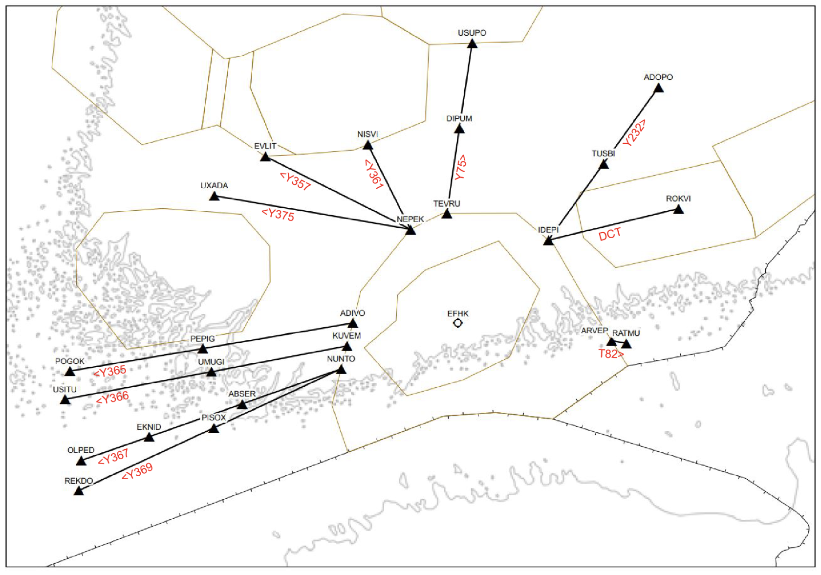
Mandatory departure routes
Pilots are requested NOT to include SID in their flight plan as this will be assigned by ATC.
IFR-flights departing from Helsinki above FL 95 shall use these mandatory routes after the SID:
EFHK TMA Boundary Point
EFHK Departure Connecting Point
Flight Plan
NUNTO
REKDO
NUNTO-Y369-REKDO-DCT
NUNTO
OLPED
NUNTO-Y367-OLPED-DCT
KUVEM
USITU
KUVEM-Y366-USITU-DCT
ADIVO
POGOK
ADIVO-Y365-POGOK-DCT
NEPEK
NISVI
NEPEK-Y361-NISVI-DCT
TEVRU
USUPO
TEVRU-Y75-USUPO-DCT
IDEPI
ADOPO
IDEPI-Y232-ADOPO-DCT
IDEPI
ROKVI
IDEPI DCT ROKVI DCT
ARVEP
RATMU
ARVEP-T82-RATMU-DCT
NEPEK
EVLIT
NEPEK-Y357-EVLIT-DCT
NEPEK
UXADA
NEPEK-Y375-UXADA-DCT
[](https://wiki.vatsim-scandinavia.org/uploads/images/gallery/2023-07/screenshot-2023-07-18-at-14-12-13.png)
After the last point of the mandatory departure route, pilots have mostly free hands to plan their flights with DCT routes.
RENKU is only available and mandatory for departures to EETN or EEEI. Maximum cruise level is FL 100.
En-route clearance
En-route clearance can be requested with DCL (datalink) or with VOICE over the ground or tower frequency depending on which ATC position is online.
If using DCL, pilots shall send the pre-dep request to identifier EFHK or EFIN, depending on which station is online. Frequency 118.125 shall be monitored when requesting clearance via DCL.
On initial contact, state aircraft type, received ATIS and QNH.
👨✈️
FASTAIR 312, AIRBUS 320, INFORMATION M, QNH 1011, REQUEST CLEARANCE TO OULU
Departure with SID:
🎧
FASTAIR 312, CLEARED TO OULU, RUNWAY 22R, TEVRU 3N DEPARTURE, CLIMB VIA SID TO 4000 FEET, SQUAWK 5542
Departure with heading:
🎧
FASTAIR 312, CLEARED TO OULU, RUNWAY 22R, AFTER DEPARTURE FLY HEADING 270, CLIMB TO 4000 FEET, EXPECT RADAR VECTORS TO TEVRU, SQUAWK 5542.
If you prefer to use a different runway due performance, you may ask it prior to receiving the en-route clearance. Runways 22L and 15 are often approved for turboprop or quiet aircraft.
If unable to follow RNAV SID, inform ATC when requesting clearance.
👨✈️
FASTAIR 312, AIRBUS 320, INFORMATION M, QNH 1011, REQUEST CLEARANCE TO OULU, NEGATIVE RNAV
Your en-route clearance will include the destination, departure runway, SID or heading and the initial climb which is usually 4000 feet. You will also receive an SSR-code which shall be selected and activated prior to taxi.
Take-off and climb
When cleared for take-off, pilots are expected to start rolling within 10 seconds of take-off clearance. Pilots unable to comply with this requirement shall notify ATC before entering the runway.
Radio transfer procedures
After take-off aircraft shall remain on tower frequency until passing 1500 FT, then contact Helsinki Radar 119.100 or 129.850, depending on your SID route.
You will find the correct radar frequency on your SID-chart. If the primary frequency is not online, contact Radar on the other frequency or Helsinki Control on 121.300.
Pilots shall automatically change to radar frequency after departure!
Initial contact with Radar after departure
When contacting Helsinki Radar, state your altitude and assigned SID. If you are assigned a
heading, report the heading to Radar on initial contact.
👨✈️
HELSINKI RADAR, FASTAIR 312, PASSING 1900 FEET, TEVRU 3N
If no further climb is given, pilot shall maintain 4000 FT.
Mandatory arrival routes
Pilots are requested to not include STAR in their flight plan route.
Arriving IFR flights with cruising level above FL 95 shall use the following routes:
Arriving traffic is informed of the runway in use and cleared for the appropriate STAR serving the arrival runway. This information is given by Area Control (EFIN/EETT) when online.
Initial contact with Helsinki Radar
Call sign
HELSINKI RADAR, FINNAIR 6
Aircraft type
AIRBUS 330
“HEAVY” or “SUPER” if necessary
HEAVY
Current flight level
FLIGHT LEVEL 154
Speed (only if assigned by ATC)
SPEED 240 KNOTS
Last received ATIS broadcast
INFORMATION SIERRA
Initial contact with Helsinki Arrival
Say your Call sign only on initial contact with Helsinki Arrival
Call sign
HELSINKI ARRIVAL, FINNAIR 6
Initial contact with Helsinki Tower
Call sign
HELSINKI TOWER, FINNAIR 6
Runway
RUNWAY 22 LEFT
Clearance for Approach
There are 2 ways to be cleared for the approach:
1. Own navigation (direct route)
- Maximum 90-degree final turn to localizer
3. Radar vectoring
- Maximum 45-degree final turn to localizer
- Maximum 30-degree final turn to localizer when simultaneous IFR approaches are in use for parallel runways
All STARs at Helsinki are so-called Open STARs. If ATC has not given approach clearance, the pilot shall continue present heading after the last waypoint on the STAR:
When aircraft is cleared for approach via own navigation, pilot shall plan a direct (DCT) instead of a vector after the last waypoint on the STAR.
🎧
SPEEDBIRD 794H, VIA KENON BIFIX CLEARED ILS APPROACH RUNWAY 22 LEFT
Visual approach
ILS is the primary approach type. Upon pilot request, ATC may give clearance for a visual approach.
ATC may advise to “maintain own separation from preceding”, if there are other aircraft approaching the airport. In that case, the separation responsibility will transfer from ATC to the pilot performing the visual approach.
🎧
SPEEDBIRD 794H, DESCEND 2000 FEET, CLEARED VISUAL APPROACH RUNWAY 15, RIGHT CIRCUIT, QNH 1011, MAINTAIN OWN SEPARATION WITH PRECEDING AIRBUS 330 HEAVY, CAUTION WAKE TURBULENCE
Aircraft on visual approach shall maintain at least 2000 FT until established on final approach course. ATC may give permission “you may leave 2000 feet before final”.
Simultaneous IFR approaches
During periods of heavy inbound traffic, dependent or independent simultaneous approaches may be used on runways 04L/R or 22L/R.
- Pilots are informed when parallel approaches are in force via ATIS:
- "SIMULTANEOUS DEPENDENT/INDEPENDENT IFR APPROACHES IN PROGRESS"
Area control will inform the landing runway as early as possible; however, pilots should plan on landing on either runway when parallel approaches are in progress.
# Ground Movement & A380
## Taxiway and Stand Limitations
[APDC limitations_08_AUG_2024.pdf](https://wiki.vatsim-scandinavia.org/attachments/299?open=true)
WEF 08 AUG 2024: Introduction of stand 404B and stand 407B on Apron 4
## Code F Operations (A380)
[EFHK_A388.pdf](https://wiki.vatsim-scandinavia.org/attachments/370?open=true)
### Parking
- Parking will happen primarily on stands W48 and 905A.
- When Remote 8 is not in use for de-icing, Code-F aircraft may also be parked on stand 815 or on intermediate holding point VS1.
- When runway 15/33 is not in use, Code-F aircraft may also be parked on:
- Intermediate holding point Y7 facing nort-west. Taxi in via Runway 15 and YL.
- Intermediate holding point Y8 facing south-east. Taxi out via YL and Runway 33. Runway 22L shall be closed until Code-F aircraft has vacated Runway 15 due to absence of Runway 22L holding point markings on runway 15.
Arriving Code-F aircraft waiting for a parking position may need to absorb delay on an intermediate holding point on Taxiway Z until the parking stand is available. Other traffic may use taxiway AV instead of Z to get around the aircraft.
# VFR traffic
Parking
General VFR traffic will normally be parked at Apron 3.
- Light aircraft pilots will usually get to choose their parking spot after landing. ATC will instruct the pilot to taxi to apron 3 via DL or AD.
- At rare occasions stand 351 or 352 may be blocked by a larger aircraft. Taxi to these stands is performed via taxiway DM.
Local restrictions
- VFR flights are restricted during peak hours and during simultaneous IFR approaches to parallel runways (04L/R or 22L/R). Check ATIS prior to flight!
- VFR flights shall not climb above 1000 FT without explicit clearance from ATC.
Helsinki Control Zone is ATS airspace classification D with vertical limits SFC - 1300 FT.
- VFR traffic is not separated from other traffic in the Control Zone
- Traffic information is given by Helsinki Tower
- VFR pilots are expected to maintain sufficient separation to other IFR or VFR traffic when traffic information is provided
Visual Reporting Point ROQQA may be used only used for SAR flights.
- Find the Visual Approach Chart [**HERE**](https://www.ais.fi/eaip/currently_effective/documents/Root_WePub/ANSFI/Charts/AD/EFHK/EF_AD_2_EFHK_VAC.pdf?open=true).
Departing VFR
- Request start-up and clearance on initial contact with ATC
- State any requests such as the use of a specific runway for departure
- ATC clearance is usually given on stand
🧑🏻✈
HELSINKI GROUND, OH-CME, CESSNA 172, APRON 3, INFORMATION MIKE, QNH 1011, REQUEST START-UP
🎧
O-ME, HELSINKI GROUND. START-UP APPROVED, RUNWAY 15, LEAVE CONTROL ZONE VIA LILJA, 1000 FT OR BELOW, SQUAWK 0355
🧑🏻✈
START-UP APPROVED, RUNWAY 15, LEAVE CONTROL ZONE VIA LILJA, 1000 FT OR BELOW, SQUAWK 0355, O-ME
- When ready for departure, ATC may give departure restrictions. Please follow all clearances given by ATC.
- Pilots are requested to report when leaving the Control Zone.
- If cleared via VRP: "O-ME, LILJA OUTBOUND"
- If cleared direct en-route: "O-ME, CONTROL ZONE BOUNDARY OUTBOUND"
Arriving VFR
- Report your position and intentions on initial contact with Helsinki Tower when approaching the Control Zone boundary.
- Helsinki tower will normally give clearance to a part of the traffic circuit serving the runway in use.
- During peak hours VFR flights might be cleared to visual holdings or to absorb delay with other means such as orbitting.
🧑🏻✈
HELSINKI TOWER, OH-CME, CESSNA 172, RADIAL 360, 20 MILES FROM HELSINKI, 1000 FT, INFORMATION MIKE, QNH 1011 FOR LANDING
🎧
O-ME, HELSINKI TOWER, VIA TURFI JOIN RIGHT BASE LEG RUNWAY 22 LEFT, 1000 FT OR BELOW
🧑🏻✈
VIA TURFI JOIN RIGHT BASE LEG 1000 FT OR BELOW, O-ME
- Pilots are requested to report once established on the downwind leg
- Pilots shall report on final if Tower has not given a clearance to use the runway (landing, touch-and-go, low approach etc.)
Traffic Circuit
- Local VFR flights (normally training flights) may be cleared for a traffic circuit.
🧑🏻✈
HELSINKI GROUND, OH-CME, CESSNA 172, REQUEST START-UP
🎧
O-ME, HELSINKI GROUND, START-UP APPROVED, CLEARED TRAFFIC CIRCUIT RUNWAY 15, 1000 FT OR BELOW, SQUAWK 0422
🧑🏻✈
START-UP APPROVED, CLEARED TRAFFIC CIRCUIT RUNWAY 15, 1000 FT OR BELOW, O-ME
- Pilots are requested to report once established on the downwind leg
- Pilots shall report on final if Tower has not given a clearance to use the runway (landing, touch-and-go, low approach etc.)
Delaying VFR traffic
- Tower may delay VFR traffic when traffic information is not sufficient
- Examples of delay action:
- orbit left/right
- make three-sixty left/right
- extend downwind
- join holding ...
- Please follow the clearances given by Helsinki Tower
Flight Plan instructions
Flight planning is an essential phase of your flight. A good flight plan will give Air Traffic Control sufficient information regarding your intentions and reduces the need to ask intentions during the flight.
Traffic circuit
Traffic circuit is marked with TC in the ROUTE field.
TC can be further specified in FPL field-18 ('remarks field') as follows:
1. Conducting one spot landing:
- RMK/1SL
2. Conducting a practiced forced landing after which the flight continues to two training areas:
- RMK/PFL 2TA
3. Conducting two spot landings after which the flight continues to a training area:
- RMK/2SL TA
Most common abbreviations
FS
Full Stop (Ladning)
LA
Low Approach
TA
Training Area
AP
Approaches
TGL
Touch and Go Landing
TC
Traffic Circuit
SL
Spot Landing
PFL
Practiced Forced Landing
PFLR
Practiced Forced Landing back to Runway
En-route flights
- It is highly recommended to plan via Visual Reporting Points. These points are indicated on the [Visual Approach Chart](https://www.ais.fi/eaip/006-2023_2023_11_30/documents/Root_WePub/ANSFI/Charts/AD/EFHK/EF_AD_2_EFHK_VAC.pdf).
- Unless otherwise specified in a flight plan, ATC will assume the aircraft will fly straight from the departure aerodrome to the destination aerodrome as filed.
- If this is to be significantly deviated from, the planned flight route must be shown in the FPL. In such a case the route can, when required, also be inserted using the plain-language place names.
- Example: (EFHK) LINTU NUMMELA VIILA (EFTP)
- If you wish to join the traffic circuit at Helsinki, add "TC" to the route and mark your requested approaches in the remarks section, e.g. "RMK/EFHK 2TGL"
### Example flight plan
VFR flight leaving Control Zone and re-entry for traffic circuit performing 2 touch-and-go landings, 2 spot landings and 1 full-stop landing:
[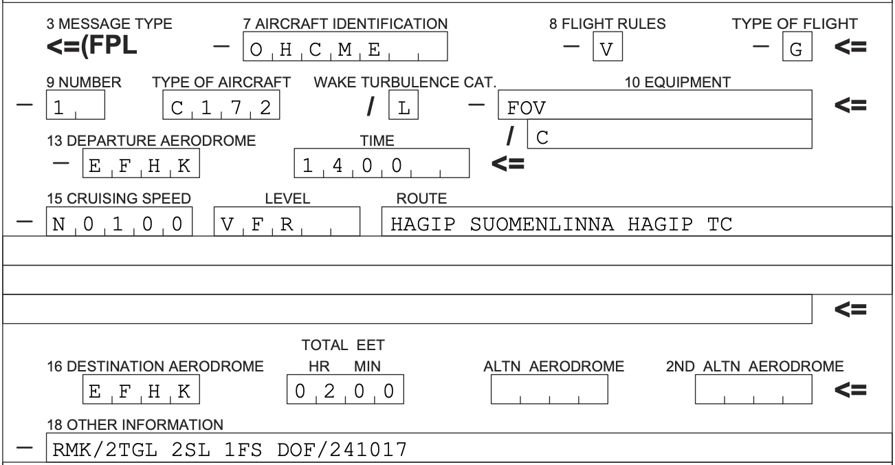](https://wiki.vatsim-scandinavia.org/uploads/images/gallery/2024-10/fpl-vfr-1.png)
## Helicopter flights
VFR helicopters may choose the take-off or landing location.
Take-off and landing locations
Location
Within Maneuvering Area?
Remarks
Runways
YES
FATO H16/H34
YES
Serving traffic to Apron 4
FATO FH10
YES
Medical helicopter FinnHEMS 10
Example phraseology:
🚁
HELSINKI TOWER, OH-HEH, ROBINSON 44, EAST OF HELSINKI, 1200 FT, ESTIMATING LILJA IN 4 MINUTES FOR LANDING, APRON 3
🎧
O-EH, HELSINKI TOWER, VIA LILJA JOIN FINAL RUNWAY 33, 1000 FT OR BELOW, QNH 1011
🚁
VIA LILJA JOIN FINAL RUNWAY 33, 1000 FT OR BELOW, QNH 1011, O-EH
🚁
O-EH, LILJA INBOUND
🎧
O-EH
🎧
O-EH, WIND VARIABLE 4 KNOTS, RUNWAY 33 CLEARED TO LAND
🚁
CLEARED TO LAND RUNWAY 33, O-EH
🎧
O-EH, AIR-TAXI VIA DL TO APRON 3
🚁
AIR-TAXI VIA DL TO APRON 3, O-EH
### Outside Maneuvering Area
When departing or landing outside of the Maneuvering Area, pilots are requested to report airborne or to report on ground. No take-off or landing clearance will be issued.
- You can view the Maneuvering Area boundaries from the Aerodrome Charts (APDC). The Area is marked with a gray line called "ATC SER BDRY" on the charts in [AIP Finland](https://aip.intor.fi/ad/efhk.html).
🎧
O-EH, WIND CALM, MAKE APPROACH TO APRON 7, REPORT ON GROUND, CLEARED TO CROSS RUNWAY 04L
🚁
MAKE APPROACH TO APRON 7, CLEARED TO CROSS RUNWAY 04L, WILCO, O-EH
## Special VFR
### VMC Conditions
Airspace class
Minimum visibility
Minimum cloud ceiling
D (Control Zone)
5 km
BKN or OVC 1000 ft
When the visibility is less than 5 km and/or when the cloud ceiling is below 1000 ft, ATC may give clearance for **Special VFR**, and the minima may be reduced to:
- minimum **visibility 1500 m**
- minimum **cloud ceiling 600 ft**
Special VFR traffic is separated from all other traffic by ATC
### Geographical Restrictions for Separation
ATC may restrict a VFR flight to remain outside of the IFR Approach Funnel in order to separate a Special VFR aircraft from other aircraft.
🎧
O-BC, leave control zone via Kitka, special VFR, after departure remain outside of IFR approach funnel. O-BC, jätä lähialue Kitkan kautta, erityis-VFR, lähdön jälkeen pysy pois IFR-lähestymisen suojaalueelta.
🎧
O-BC, report when outside of IFR approach funnel. O-BC, ilmoita kun pois IFR-lähestymisen suoja-alueelta.
🎧
O-BC, LEAVE CONTROL ZONE VIA LINTU, SPECIAL VFR, AFTER DEPARTURE REMAIN OUTSIDE OF IFR APPROACH FUNNEL
🎧
O-BC, REPORT WHEN OUTSIDE OF IFR APPROACH FUNNEL
ATC may give a warning when a possibility of IMC conditions is present, especially during a change from IFR to VFR.
🎧
O-BC, INSTRUMENT METEOROLOGICAL CONDITIONS REPORTED / FORECASTED IN THE VICINITY OF HELSINKI
👨✈️
ROGER, MAINTAINING IFR, O-BC
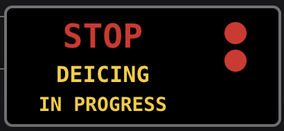
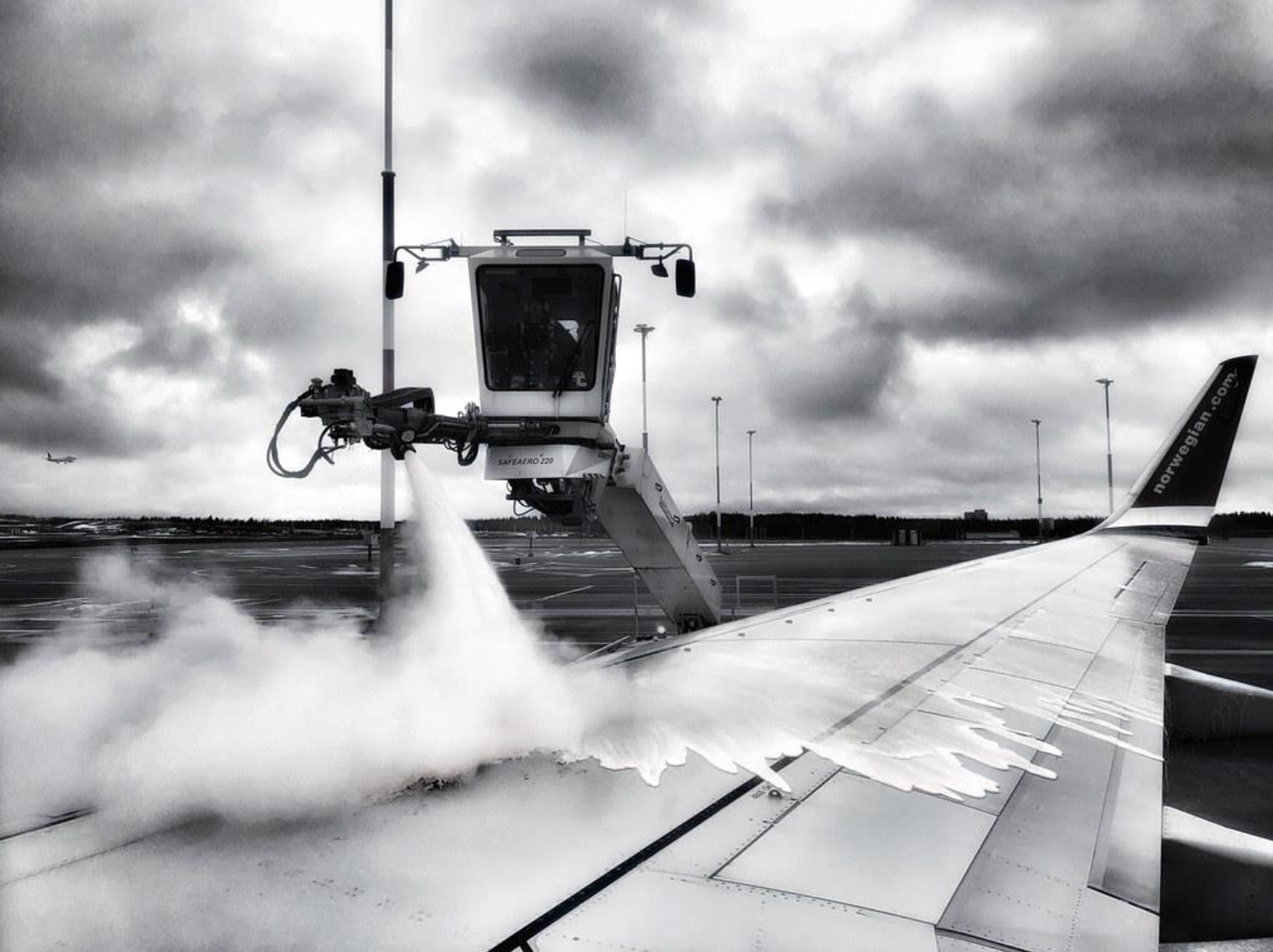
# De-icing procedures
[](https://wiki.vatsim-scandinavia.org/uploads/images/gallery/2023-10/screenshot-2023-10-15-at-19-59-47.png)
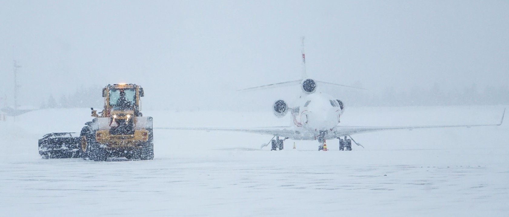
At Helsinki Airport we are delighted to provide proper de-icing services for your needs! Helsinki is known for its smooth winter operations, so why not bring it here to Vatsim! To make your experience better, we recommend using GSX PRO to simulate remote de-icing.
The following positions can be manned during winter season:
Logon code
Call sign
Frequency
EFHK_C_GND
Remote De-icing Supervisor
133.850
EFHK_D_GND
De-icing (operator)
121.675
The positions above may be used during Welcome to HEL or other events.
Pilots may request for de-icing even if the positions above are not manned. In that case Helsinki Ground or Tower will handle the communications.
Pilot procedures
Before start-up
1. Order de-icing from Remote De-icing Supervisor 133.850 before start-up OR use the [**De-icing Web Application**](https://ice.lusep.fi/) (instructions at the end of this page). You need to receive en-route clearance from EFHK_DEL before requesting de-icing:
✈️
HELSINKI DE-ICING, FINNAIR 1, REQUEST DEICING FOR WINGS AND TAIL
🎧
FINNAIR 1, DE-ICING ON REMOTE APRON 6
2. After the request you may switch back to previous frequency
Operations at remote de-icing apron
1. ATC will give you taxi instructions to an intermediate holding point
- Apron 6: DC1 or GC1
- Apron 8: AV13 or VS1
2. ATC will advise you to contact Remote De-icing Supervisor:
3. You will receive taxi instructions to de-icing stand
✈️
FINNAIR 1, APPROACHING DC1
🎧
FINNAIR 1, TAXI TO STAND 603
✈️
TAXI TO STAND 603, FINNAIR 1
4. De-icing Supervisor may advise you to contact de-icing operator when parking brake is set
🎧
FINNAIR 1, WHEN PARKING BRAKE SET, CONTACT DE-ICING 121.675
✈️
WHEN PARKING BRAKE SET, 121.675, FINNAIR 1
5. Contact De-icing operator and request the de-icing procedure you want
- General tip: request 2-step de-icing only when it is snowing
✈️
DE-ICING, FINNAIR 1, PARKING BRAKE SET, REQUESTING ONE STEP DE- ICING FOR WINGS AND STABILIZER, YOU MAY START SPRAYING
🎧
FINNAIR 1 ON STAND 603, DE-ICING, STARTING ONE STEP PROCEDURE FOR WINGS AND STABILIZER, REPORT WHEN DE-ICING COMPLETED
✈️
WILCO, FINNAIR 1
6. Now you will wait until the de-icing in your simulator is completed. When de-icing is finished, the de-icing operator will give you the end report which should be read back:
✈️
FINNAIR 1, STAND 601, DE-ICING COMPLETED
🎧
FINNAIR 1 ON STAND 601, DE-ICING COMPLETED FOR WINGS AND TAIL WITH TYPE 1 FLUID, MIXTURE 40%, HOLDOVER TIME STARTED AT 55, POST DE- AND ANTI-ICING CHECKS ARE COMPLETED
✈️
TYPE 1, MIXTURE 40%, HOLD OVER TIME 55, FINNAIR 1
🎧
FINNAIR 1, CORRECT, FOR TAXI CONTACT TOWER 118.850
✈️
118.850, FINNAIR 1
7. The de-icing process is now completed, and you will receive taxi instructions towards the departure runway – Have a nice flight! 🙂
[](https://wiki.vatsim-scandinavia.org/uploads/images/gallery/2026-07/remote8-2605.jpg)
## DEICE Application for EFHK
### [ice.lusep.fi](https://ice.lusep.fi/)
De‑icing decision support powered by real‑world operations of SureWx. For flight simulation use only.
You need to be connected on VATSIM network as a pilot and send the flight plan with departure EFHK before connecting to the application.
### 1. Check Weather
Verify METAR and modify the ``Temperature`` and ``Precipitation`` manually if required.
- The manual selection also includes:
- Active Frost
- Rain on Cold-Soaked Wing
Some Precipitation selections require the use of ``Snowfall Intensifies as a Function of Prevailing Visibility`` -table. This has been simplified with the following form:
[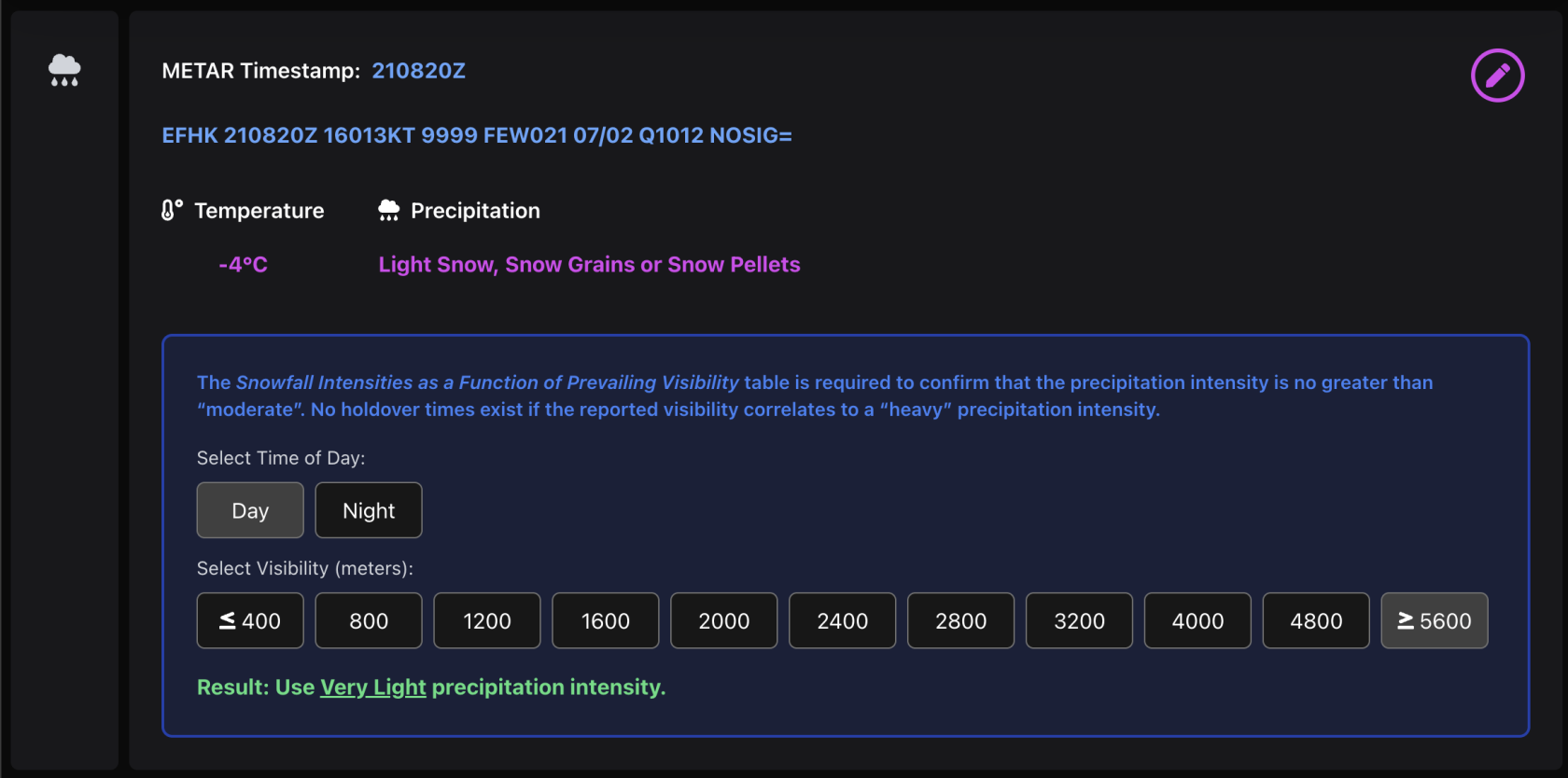](https://wiki.vatsim-scandinavia.org/uploads/images/gallery/2025-10/image-1761036558371.png)
Edit the ``Precipitation`` to match the Form ``Result``.
- In the case above, the already selected ``Light Snow, Snow Grains or Snow Pellets`` should be changed to ``Very Light Snow, Snow Grains or Snow Pellets``.
### 2. Request Treatment
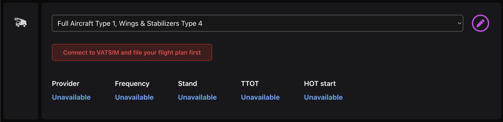
Select the preferred ``DEICE Treatment`` from the dropdown menu. This list includes all possible alternatives available at Helsinki.
[](https://wiki.vatsim-scandinavia.org/uploads/images/gallery/2025-10/image-1761036878586.png)
- Normally ``Type 4`` fluid is selected only in snowy conditions or whenever ``Type 1`` Fluid holdover time (HOT) is not enough
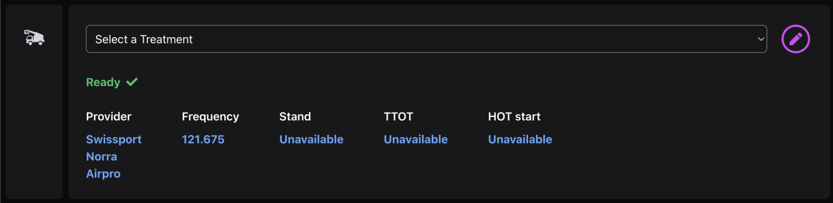
After the ``Remote Deicing Supervisor`` has approved your ``DEICE Treatment``, it will be shown as "Ready" in the Treatment section:
[](https://wiki.vatsim-scandinavia.org/uploads/images/gallery/2025-10/image-1761036992679.png)
### 3. Taxi to Remote Apron
After the approved ``DEICE Treatment`` you can continue your preparations normally. Later you will receive taxi to the Remote Deicing apron by ATC.
### 4. Adhere to possible Holdover Time
[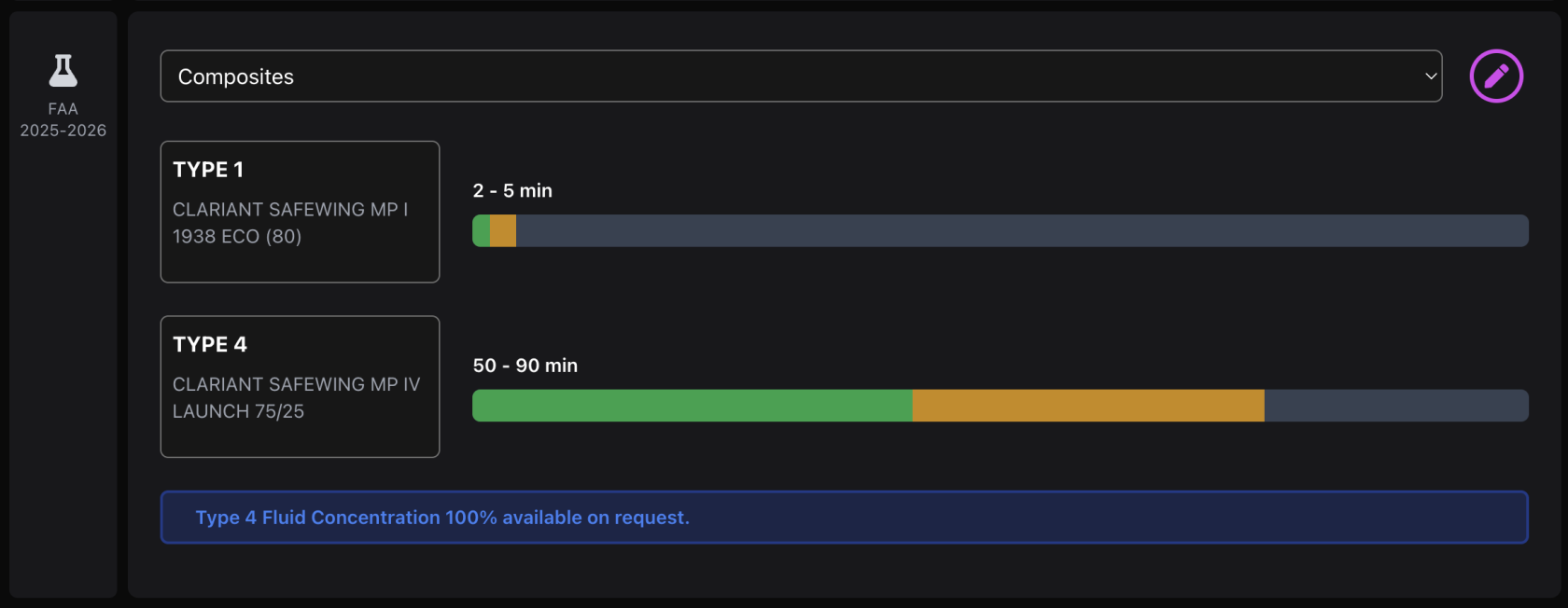](https://wiki.vatsim-scandinavia.org/uploads/images/gallery/2025-10/image-1761037250996.png)
The holdover time is the time when the last step of the treatment has started. If using both ``Type 1`` and ``Type 4`` fluids, the HOT starts when the ``Type 4`` is being applied.
As seen in the example above, Type 1 would not give sufficient Holdover Time for the selected temperature and precipitation, as it would be impossible to complete the Deice treatment and taxi to the runway within 5 minutes. Therefore Type 4 is also applied which is an anti-icing fluid keeping the wing clear of precipitation for a longer period.
[](https://wiki.vatsim-scandinavia.org/uploads/images/gallery/2025-10/image-1761037579765.png)
The Timer may be used to track the Holdover Time progress. The HOT included in the end-report given by the ``Remote Deicing Supervisor`` is the time when your de-icing was marked as started (not necessarily when you have started to apply the last fluid on your aircraft in the simulator).
### Aircraft de-icing visual guidance system
The small box appearing in the bottom-right corner of the page simulates the ``De-icing visual guidance system`` at Helsinki. This system is located next to each Remote stand.
# 🔵 EFIV - Ivalo
[](https://wiki.vatsim-scandinavia.org/uploads/images/gallery/2023-10/efivpilot.jpg)
Located in the pristine landscapes of northern Lapland, Ivalo Airport serves as **one of Finland's key entry points to the Arctic wonders**. Situated approximately 9 kilometers from the Ivalo village and in close proximity to the popular Saariselkä ski resort, this airport welcomes travelers and aviators eager to experience the mesmerizing northern lights, vast tundra expanses, and thrilling winter adventures that only this unique region can offer.
Ivalo Airport has a single asphalt runway capable of accommodating a variety of aircraft, ranging from small private planes to larger commercial airliners.
IATA
ICAO
Charts
IVL
EFIV
[Chartfox - EFIV](https://chartfox.org/EFIV)
## ATC positions
Ivalo is a controlled airport with aerodrome control- and approach control service. The service is combined to one Air Traffic Controller (tower-radar).
Pilots can identify the level of service provided from the Vatsim logon code (or by the ATC information text):
Logon code
Call sign
Frequency
Responsibilities
EFIV\_R\_TWR
IVALO TOWER
118.000
Ground movement, Ivalo Control Zone & Terminal Area
## Ground layout
[](https://wiki.vatsim-scandinavia.org/uploads/images/gallery/2023-10/efivrwy.png)
- The main apron is located next to the Control Tower southeast of the runway
- Access the main apron via B or E
- The general aviation apron can be accessed via taxiway C
### Runways
Ivalo is equipped with one runway 04/22. When the wind direction and weather conditions allows, the runway is usually selected to suit the traffic needs. Runway 04 is often used which allows for a shorter arrival route and eliminates the need of backtracks.
Take-offs from runway intersections can be performed upon the pilot's request the traffic situation permitting.
### Currently available stands
### Stand restrictions & push back procedures
- All stands on the main apron can fit airplanes up to A321/B739
- In low traffic levels ATC will assign stands in order to eliminate the need of push back
## En-route clearance
Please, do not include the SID in your flight plan route.
By default the local tower controller will give clearance to requested cruise flight level.
### Departure with SID:
Fastair 312, cleared to Helsinki, runway 22, direct Ibosu, flight level 350, squawk 5542
Fastair 312, selvä Helsinkiin, kiitotie 22, lähdöstä suoraan Ibosu, lentopinta 350, koodaa 5542
## Approach
Please, do not include the STAR in your flight plan route.
Runway 22 is the only runway with an **ILS approach system**. This makes runway 22 the preferred runway in Low Visibility conditions.
When approaching runway 04, pilots may expect to be cleared for RNP approach (or visual approach upon pilot request).
Arriving aircraft may be cleared for the approach already on initial contact with the local controller. Please be ready to copy any clearance and instructions.
### Phraseology example:
- On initial contact with approach control, please include the following:
- Call sign
- Current flight level
- Assigned flight level
- Aircraft type (and wake turbulence category if necessary)
- Received ATIS broadcast
- Other restrictions given by previous controller
👨✈️
Ivalo tower, Finnair 639, passing flight level 192, descending flight level 100, Airbus 321, information L
Ivalon torni, Finnair 639, läpi lentopinta 192, laskeudutaan lentopinnalle 100, Airbus 321, tiedotus L
🎧
Finnair 639, Ivalo tower, radar contact, continue descent to 3500 feet, QNH 1014, cleared RNP approach runway 04, report final approach course, for information next 15 miles below flight level 95 uncontrolled airspace
Finnair 639, Ivalon torni, tutkayhteys, jatka laskeutumista 3500 jalkaan, QNH 1014, selvä RNP lähestymiseen kiitotie 04, ilmoita loppulähestymissuunnassa, tiedoksi seuraavat 15 mailia alle lentopinnan 95 valvomatonta ilmatilaa
## Operations in Low Visibility Conditions
Take-offs are allowed when the reported RVR is between 550 meters and 400 meters, provided that only one aircraft at a time is in the manoeuvring area.
Ivalo has only ILS CAT I approach available for runway 22 with the following minimas OCA (H):
- Category A: 616 (152)
- Category B: 627 (163)
- Category C: 638 (174)
- Category D: 651 (187)
There are also LPV approaches available for both runways (Lateral Precision with Vertical Guidance Approach). See the [RNP approach charts](https://aip.intor.fi/ad/efiv.html) for more information.
# 🔵 EFJY - Jyväskylä
[](https://wiki.vatsim-scandinavia.org/uploads/images/gallery/2024-10/1024px-jyvaskyla-airport-1.jpg)Image: kallerna. Wikimedia Commons, CC-BY-SA-4.0.
Jyväskylä Airport is situated in central Finland, around 20 kilometers north of Jyväskylä city center. It serves as a hub for both commercial and general aviation activities, though it primarily handles charter and training flights rather than regular commercial passenger services.
The airport is also home to a Finnish Air Force base, where the Air Force Academy conducts flight training and various military operations.
IATA
ICAO
Charts
JYV
EFJY
[Chartfox - EFJY](https://chartfox.org/EFJY)
## ATC positions
Jyväskylä is a controlled airport with aerodrome control- and approach control service. This service can be combined (tower-radar), or separate. Jyväskylä Arrival and/or Ground can also be opened according to the demand.
Logon code
Call sign
Frequency
Responsibilities
EFJY\_GND
JYVÄSKYLÄ GROUND
121.850
ATC Clearance & Ground Movement
EFJY\_TWR
JYVÄSKYLÄ TOWER
118.000
Jyväskylä Control Zone
EFJY\_R\_TWR
JYVÄSKYLÄ TOWER
118.000
Jyväskylä Control Zone & Terminal Area
EFJY\_APP
JYVÄSKYLÄ RADAR
127.000
Jyväskylä Terminal Area
EFJY\_R\_APP
JYVÄSKYLÄ ARRIVAL
128.800
Jyväskylä Terminal Area - arrivals below 5000 FT
## Ground layout
[](https://wiki.vatsim-scandinavia.org/uploads/images/gallery/2024-10/efjy-rwy.png)
- The main apron is located next to the Control Tower north-east of the runway
- Stands 1, 2, 3 and 4 may be used for passenger flights
- All stands are designed so that push back is not necessary
- General aviation aircraft are usually parked on the apron next to taxiway V
The area south of the runway is for military only. There are also taxiways north of taxiway T leading to aprons for military traffic and QRA flights.
### Runways
Jyväskylä airport has one runway, 12/30.
The ILS (Instrument Landing System) is in use for runway 30 only. The ILS system is used to conduct approaches under normal circumstances and in limited visibility conditions. The flight routes near the airport and the choice of runway direction are influenced by external conditions, such as wind speed and direction, cloud base, visibility, runway conditions, available approach procedures, and traffic situation.
Take-offs from runway intersections can be performed upon the pilot's request the traffic situation permitting
### Stand restrictions
- Stands 1, 2, 3 and 4 on the Civil Apron can fit up to Code C aeroplanes. Use caution when moving on the apron, especially if the other stand is blocked
- Military aircraft will not be assigned a stand after arrival. ATC will only give "taxi to Apron"
## En-route clearance
Please, do not include the SID in your flight plan route.
By default the local tower controller will give clearance to requested cruise flight level.
There are no SID routes at Jyväskylä. Pilots may expect a DCT route or vector after departure.
- Please check the [OMNIDIRECTIONAL DEPARTURES](https://aip.intor.fi/ad/efjy.html) chart for the turning altitude:
- **RWY 12**: Climb straight ahead until 850 FT, then turn towards cleared waypoint or heading
- **RWY 30**: Climb straight ahead until 1130 FT, then turn towards cleared waypoint or heading
### Departure with direct route:
Fastair 312, cleared to Helsinki, runway 12, after departure fly heading 090, climb to flight level 190, expect vectoring to Xelma, squawk 5542
Fastair 312, selvä Helsinkiin, kiitotie 12, lähdön jälkeen lennä ohjaussuuntaan 090, nouse lentopinnalle 190, odota tutkavektorointia Xelmalle, koodaa 5542
## Approach
Please, do not include the STAR in your flight plan route.
Runway 30 is the only runway with an **ILS approach system**. This makes runway 30 the preferred runway during Low Visibility Operations.
- **ILS Z approach** is used for RNAV capable aircraft
- **ILS Y approach** is used for non-RNAV aircraft (based on VOR navigation)
When runway 12 is in use, pilots may expect to be cleared for RNP approach.
Arriving aircraft may be cleared for the approach already on initial contact with the local controller. Please be ready to copy any clearance and instructions.
### Phraseology example:
- On initial contact with approach control, please include the following:
- Call sign
- Current flight level
- Assigned flight level
- Aircraft type (and wake turbulence category if necessary)
- Received ATIS broadcast
- Other restrictions given by previous controller
👨✈️
Jyväskylä tower, Finnair 285, flight level 190, when ready descending flight level 100, ATR 72, information L
Jyväskylän torni, Finnair 285, lentopinta 190, kun valmis laskeudutaan lentopinnalle 100, ATR 72, tiedotus L
🎧
Finnair 285, Jyväskylä tower, radar contact, when ready descent to 2900 feet, QNH 998, via Etnup cleared RNP approach runway 12, report final approach course, for information next 20 miles below flight level 95 uncontrolled airspace
Finnair 285, Jyväskylän torni, tutkayhteys, jatka laskeutumista 2900 jalkaan, QNH 998, Etnupin kautta selvä RNP lähestymiseen kiitotie 12, ilmoita loppulähestymissuunnassa, tiedoksi seuraavat 20 mailia alle lentopinnan 95 valvomatonta ilmatilaa
## Operations in Low Visibility Conditions
Take-offs are allowed when the reported RVR is between 400 meters and 300 meters, provided that only one aircraft at a time is in the manoeuvring area.
The Low Visibility Procedures for Take-offs (LVPTO) procedure will be taken in force gradually as follows:
- RVR is 800 - 550 M
- RVR is less than 550 M
- Procedure will be in force when Touchdown zone (TDZ) or Midpoint or Stop End RVR-value falls below 550 M.
ATC will give the real RVR value(s) on frequency prior take-off or landing or whenever requested by the pilot.
The application of LVP procedures will be informed to the pilots by ATIS or ATC: "**LOW VISIBILITY TAKE OFF PROCEDURES IN OPERATION**".
Jyväskylä has only ILS CAT 1 approach available for runway 30.
There are also LPV approaches available for both runways (Lateral Precision with Vertical Guidance Approach). See the [RNP approach charts](https://aip.intor.fi/ad/efjy.html) for more information.
## VFR Traffic Restrictions
If necessary, the number of aircraft cleared to fly in the aerodrome traffic circuit is restricted by ATC. The number of aircraft is determined by e.g. weather conditions or other traffic.
VFR traffic will normally be cleared via Visual Reporting Points (VRP) marked on the Visual Approach Chart in order to reduce noise impact and to better control the flow in and out of the Control Zone.
# 🔵 EFKT - Kittilä
[](https://wiki.vatsim-scandinavia.org/uploads/images/gallery/2023-07/kittila.jpg)
Located in the heart of Lapland, Kittilä Airport is the gateway to a winter wonderland, serving as **one of the busiest winter-season airports in Finland**. Approximately 5 kilometers from Kittilä town center and 35 kilometers from the Levi ski resort, it is the perfect starting point for travelers and pilots drawn to the captivating northern lights, untouched wilderness, and winter sports activities this region offers.
Kittilä Airport has a single asphalt runway capable of accommodating a variety of aircraft, ranging from small private planes to larger commercial airliners.
IATA
ICAO
Charts
KTT
EFKT
[Chartfox - EFKT](https://chartfox.org/EFKT)
## ATC positions
Kittilä is a controlled airport with aerodrome control- and approach control service. The service is combined to one Air Traffic Controller (tower-radar).
During low traffic, Kittilä airport can also be operated with [AFIS (Aerodrome Flight Information Service)](https://wiki.vatsim-scandinavia.org/books/finnish-airports-charts/page/aerodromes-with-afis).
Pilots can identify the level of service provided from the Vatsim logon code (or by the ATC information text):
Logon code
Call sign
Frequency
Responsibilities
EFKT\_DEL
KITTILÄ DELIVERY
123.100
Clearance delivery during peak hours
EFKT\_R\_TWR
KITTILÄ TOWER
120.150
Ground movement, Kittilä Control Zone & Terminal Area
EFKT\_I\_TWR
KITTILÄ INFORMATION
120.150
Ground movement, Kittilä Upper- and Lower Flight Information Zones
## Ground layout
[](https://wiki.vatsim-scandinavia.org/uploads/images/gallery/2023-07/jhprunway.png)
- The main apron is located next to the Control Tower east of the runway
- The main apron has recently been enlargened and the main taxiway T has been extended to holding point L.
### Runways
Kittilä is equipped with one runway 16/34. The preferred runway is considered to be runway 16 for departures and runway 34 for arrivals.
Take-offs from runway intersections can be performed upon the pilot's request the traffic situation permitting.
### Currently available stands
### Stand restrictions & push back procedures
- All stands on the main apron can fit airplanes up to A321/B739
- Stands 11B, 13B and 14B are used when possible to eliminate the need of push back
- These stands are often used during summer season when traffic levels are lower
- When these stands are occupied, stands 11, 12, 13, 14 and 15 can not be used
- All other stands (7 - 18) require push back for Code C aircraft and bigger.
## En-route clearance
Please, do not include the SID in your flight plan route.
By default the local tower controller will give clearance to requested cruise flight level.
### Departure with SID:
Fastair 312, cleared to Helsinki, runway 16, direct Tugpu, flight level 350, squawk 5542
Fastair 312, selvä Helsinkiin, kiitotie 15, lähdöstä suoraan Tugpu, lentopinta 350, koodaa 5542
## Approach
Please, do not include the STAR in your flight plan route.
Runway 34 is the only runway with an **ILS approach system**. This makes runway 34 the preferred runway during Low Visibility Operations.
- **ILS Z or LOC Z approach** is used for RNAV capable aircraft
- **ILS Y or LOC Y approach** is used for non-RNAV aircraft (ADF and DME required)
When approaching runway 16, pilots may expect to be cleared for LOC or RNP approach.
Arriving aircraft may be cleared for the approach already on initial contact with the local controller. Please be ready to copy any clearance and instructions.
### Phraseology example:
- On initial contact with approach control, please include the following:
- Call sign
- Current flight level
- Assigned flight level
- Aircraft type (and wake turbulence category if necessary)
- Received ATIS broadcast
- Other restrictions given by previous controller
👨✈️
Kittilä tower, Finnair 8LD, passing flight level 192, descending flight level 100, Embraer 190, information L
Kittilän torni, Finnair 8LD, läpi lentopinta 192, laskeudutaan lentopinnalle 100, Embraer 190, tiedotus L
🎧
Finnair 8LD, Kittilä tower, radar contact, continue descent to 3800 feet, QNH 1014, cleared LOC-Z approach runway 16, right circuit, report established on localizer, for information next 17 miles below flight level 95 uncontrolled airspace
Finnair 8LD, Kittilän torni, tutkayhteys, jatka laskeutumista 3800 jalkaan, QNH 1014, selvä LOC-Z lähestymiseen kiitotie 16, oikea kierros, ilmoita suuntasäteessä, tiedoksi seuraavat 16 mailia alle lentopinnan 95 valvomatonta ilmatilaa
## Operations in Low Visibility Conditions
Take-offs are allowed when the reported RVR is between 550 meters and 400 meters, provided that only one aircraft at a time is in the manoeuvring area.
Kittilä has only ILS CAT I approach available for runway 34 with the following minimas OCA (H):
- Category A: 844 (200)
- Category B: 858 (214)
- Category C: 875 (231)
- Category D: 895 (251)
There is also LPV approaches available for both runways (Lateral Precision with Vertical Guidance Approach). See the [RNP approach charts](https://aip.intor.fi/ad/efkt.html) for more information.
# 🔵 EFKU - Kuopio
[](https://wiki.vatsim-scandinavia.org/uploads/images/gallery/2023-07/kuopio-airport-from-air.jpg)
Kuopio Airport is located in the heart of Finland's northern Lakeland district, approximately 14 kilometers north of Kuopio city center. It is the **seventh busiest airport in Finland**, serving both commercial and general aviation flights.
Kuopio also has a Finnish Air Force base, with the Karelia Air Command making use of the airport for various training and operational purposes.
## ATC positions
Kuopio is a controlled airport with aerodrome control- and approach control service. This service can be combined (tower-radar), or separate. Kuopio Arrival position can also be opened when arrival rate is high.
Logon code
Call sign
Frequency
Responsibilities
EFKU\_TWR
KUOPIO TOWER
120.150
Ground movement, Kuopio Control Zone
EFKU\_R\_TWR
KUOPIO TOWER
120.150
Ground movement, Kuopio Control Zone & Terminal Area
EFKU\_APP
KUOPIO RADAR
130.600
Kuopio Terminal Area
EFKU\_R\_APP
KUOPIO ARRIVAL
122.850
Kuopio Terminal Area - arrivals below 5000 FT
## Ground layout
[](https://wiki.vatsim-scandinavia.org/uploads/images/gallery/2023-07/ixqrunway.png)
- The main apron is located next to the Control Tower south of the runway
- Stands 1, 2, 3 and 4 can be used for passenger flights
- All stands are designed so that push back is not necessary
- General aviation aircraft are usually parked on the apron next to taxiway H
There is a military apron south of the runway next to taxiways L and G. There are also two aprons north of the runway used for military traffic and QRA flights.
### Runways
Kuopio is equipped with one runway 15/33. The preferred runway is considered to be runway 15 for departures and runway 33 for arrivals.
Take-offs from runway intersections can be performed upon the pilot's request the traffic situation permitting
### Currently available stands
### Stand restrictions
- Stands 1, 2, 3 and 4 can fit up to Code C aeroplanes. Use caution when moving on the apron, especially if the other stand is blocked
- There are two additional unmarked parking stands A and B that can fit Code E aeroplanes. These stands shall not be used for smaller aeroplanes
[](https://wiki.vatsim-scandinavia.org/uploads/images/gallery/2023-07/screenshot-2023-07-28-at-22-52-54.png)
🔵 Code E aeroplanes
---
When stand A is in use, the main taxiway between B and C cannot be used. Additionally stand 4 shall be empty.
When stand B is in use, stands 3 and 4 shall be empty.
---
#### Code E aeroplanes
Code
ICAO
Aircraft type
Wingspan M
🔵 E
B77W, B77L
Boeing 777-300ER, -200LR, -F
64.8
🔵 E
A359, A35K
Airbus A350-900, A350-1000
64.75
🔵 E
B744
Boeing 747-400
64.44
🔵 E
A345, A346
Airbus A340-500, -600
63.45
🔵 E
B772, B773
Boeing 777-300, -200
60.93
🔵 E
A332, A333, A342, A343
Airbus A330-200, -300, Airbus A340-200, -300
60.3
🔵 E
B788, B789, B78X
Boeing Dreamliner 787-8, 787-9, 787-10
60.12
🔵 E
IL96
Iljushin IL-96
60.11
🔵 E
B742, B743
Boeing 747-200, -300
59.6
## En-route clearance
Please, do not include the SID in your flight plan route.
By default the local tower controller will give clearance to requested cruise flight level.
### Departure with SID:
Please, do not include the STAR in your flight plan route.
Runway 33 is the only runway with an **ILS approach system**. This makes runway 33 the preferred runway during Low Visibility Operations.
- **ILS Z approach** is used for RNAV capable aircraft
- **ILS Y approach** is used for non-RNAV aircraft (based on VOR navigation)
When approaching runway 15, pilots may expect to be cleared for RNP approach.
Arriving aircraft may be cleared for the approach already on initial contact with the local controller. Please be ready to copy any clearance and instructions.
### Phraseology example:
- On initial contact with approach control, please include the following:
- Call sign
- Current flight level
- Assigned flight level
- Aircraft type (and wake turbulence category if necessary)
- Received ATIS broadcast
- Other restrictions given by previous controller
👨✈️
Kuopio tower, Finnair 42T, flight level 190, when ready descending flight level 100, ATR 72, information L
Kuopion torni, Finnair 42T, lentopinta 190, kun valmis laskeudutaan lentopinnalle 100, ATR 72, tiedotus L
🎧
Finnair 42T, Kuopio tower, radar contact, when ready descent to 2700 feet, QNH 998, via Giluv cleared ILS-Z approach runway 33, report established on localizer, for information next 20 miles below flight level 95 uncontrolled airspace
Finnair 42T, Kuopion torni, tutkayhteys, jatka laskeutumista 2700 jalkaan, QNH 998, Giluvin kautta selvä ILS-Z lähestymiseen kiitotie 33, ilmoita suuntasäteessä, tiedoksi seuraavat 20 mailia alle lentopinnan 95 valvomatonta ilmatilaa
## Operations in Low Visibility Conditions
Take-offs are allowed when the reported RVR is between 550 meters and 400 meters, provided that only one aircraft at a time is in the manoeuvring area.
Kuopio has only ILS CAT 1 approach available for runway 33 with the following minimas OCA (H):
- Category A: 469 (153)
- Category B: 479 (163)
- Category C: 491 (175)
- Category D: 503 (187)
There is also LPV approaches available for both runways (Lateral Precision with Vertical Guidance Approach). See the [RNP approach charts](https://aip.intor.fi/ad/efku.html) for more information.
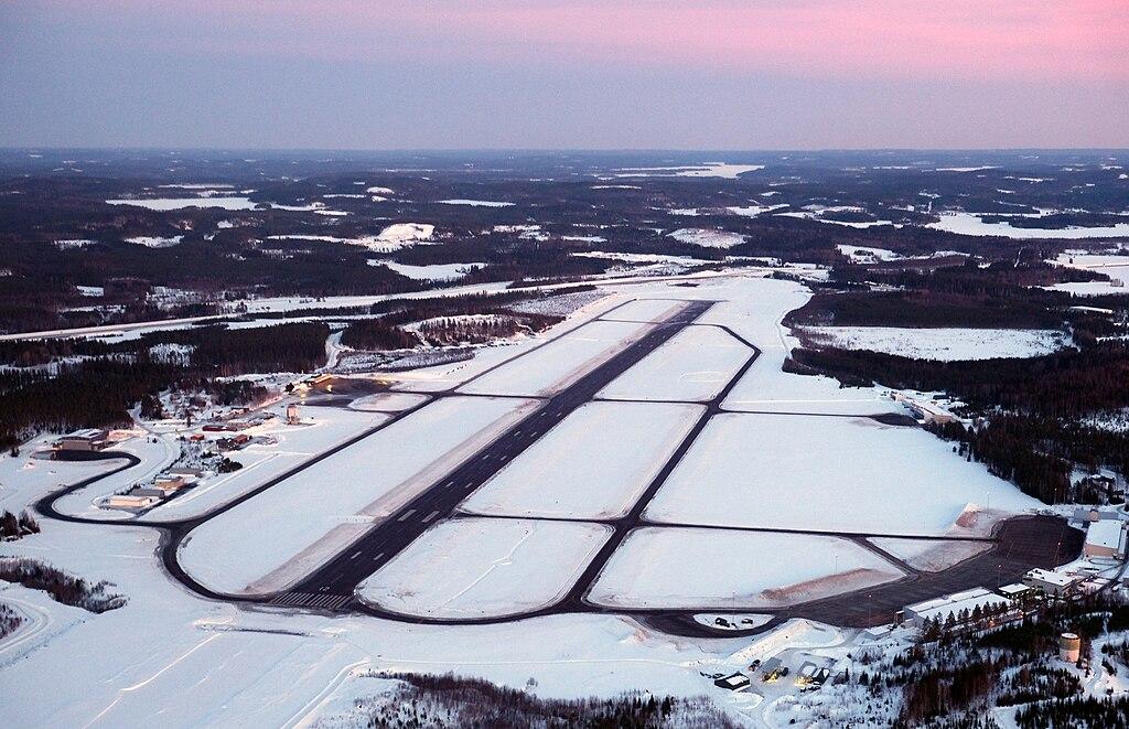
# 🔵 EFOU - Oulu
[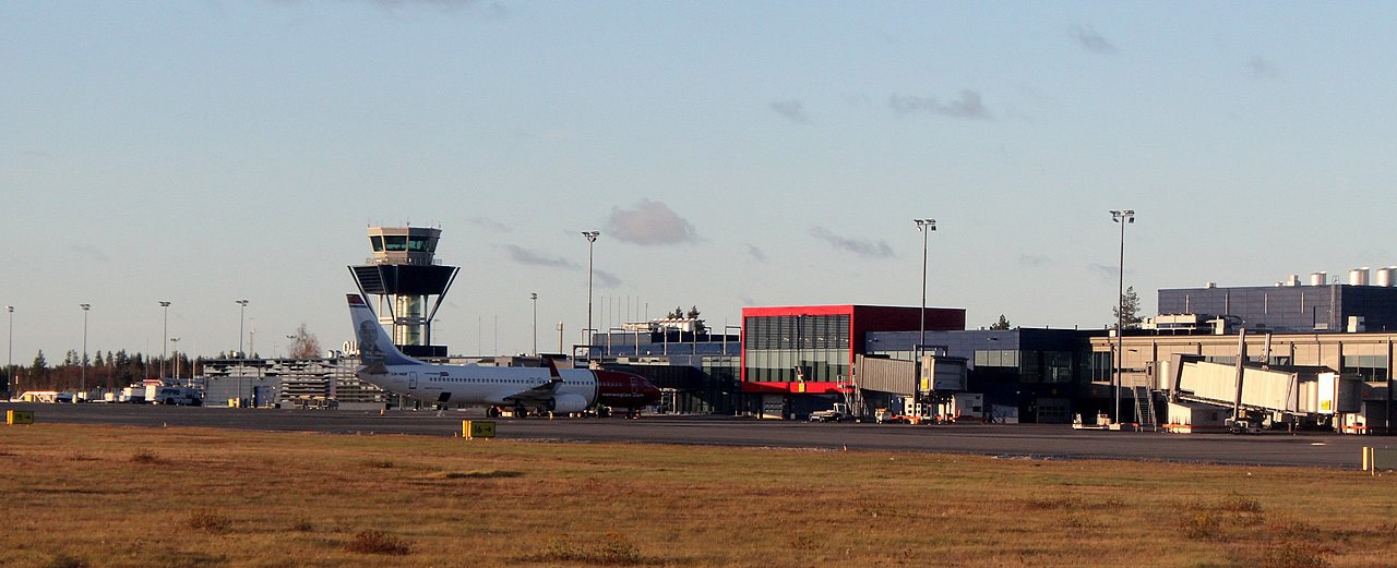](https://wiki.vatsim-scandinavia.org/uploads/images/gallery/2023-07/oulu-airport2.jpg)
Oulu Airport is not only the **second busiest in Finland**, but also serves as a significant gateway to Northern Scandinavia. Situated approximately 11 kilometers west of the Oulu city center, this airport plays an instrumental role in connecting the Northern part of the country with the rest of Finland.
The airport, operated by Finavia, handled over a million passengers in 2019 and serves as a hub for diverse types of air traffic. While it primarily serves commercial airlines, it also supports a variety of other aircraft including general aviation, parachute jump flights, private jets and medical helicopter service.
## ATC positions
Oulu is a controlled airport with aerodrome control- and approach control service. This service can be combined (tower-radar), or separate.
Logon code
Call sign
Frequency
Responsibilities
EFOU\_TWR
OULU TOWER
124.400
Ground movement, Oulu Control Zone
EFOU\_R\_TWR
OULU TOWER
124.400
Ground movement, Oulu Control Zone & Terminal Area
EFOU\_APP
OULU RADAR
118.150
Oulu Terminal Area
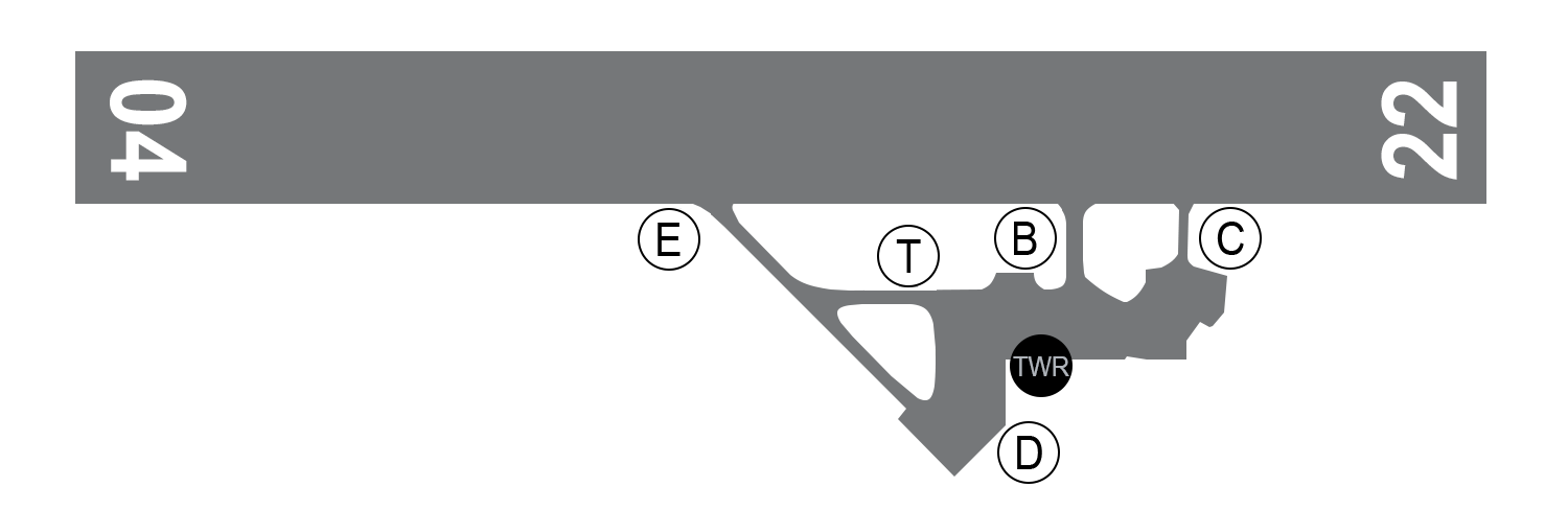
## Ground layout
[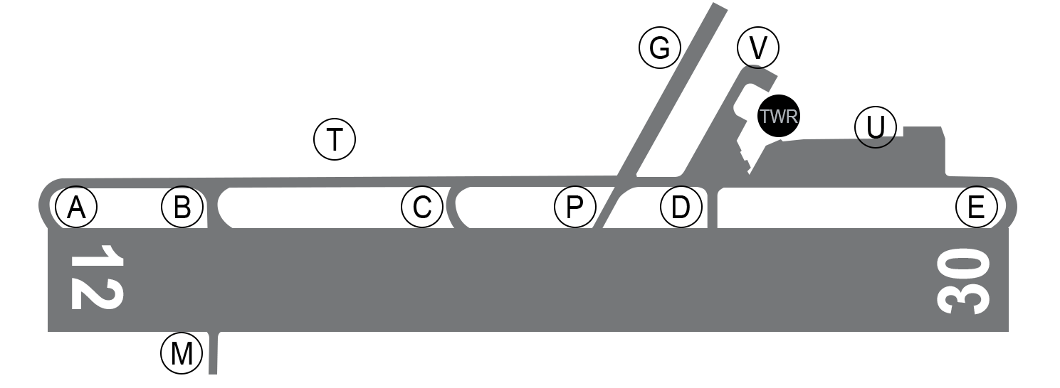](https://wiki.vatsim-scandinavia.org/uploads/images/gallery/2023-07/zxhrunway.png)
- The main apron is located north of runway 30 threshold
- Stands 13 to 16 are equipped with jetbridges
- General aviation aircraft are usually parked at Apron 3 (taxiway G)
- Medical helicopter base is located at the end of taxiway V
Military apron is located south of the runway at taxiway M.
### Runways
Oulu is equipped with one runway 12/30. The preferred runway is considered to be runway 12 for arrivals and runway 30 for departures.
Take-offs from the runway intersections can be performed upon the pilot's request the traffic situation permitting **0500-2000 UTC (0400-1900 UTC)**.
### Currently available stands
### Stand restrictions
[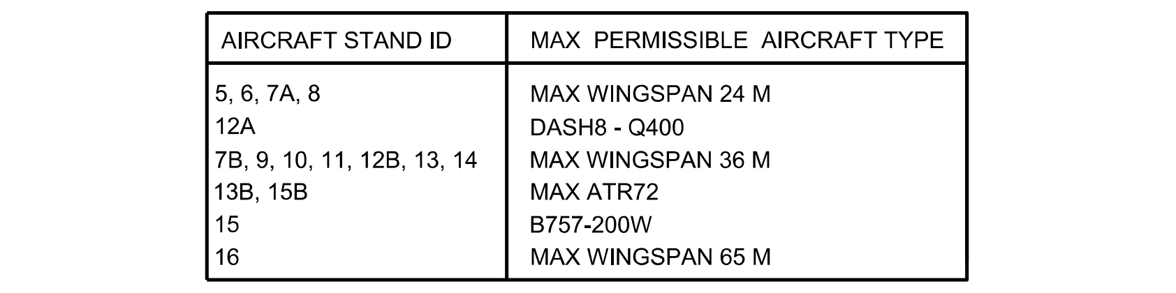](https://wiki.vatsim-scandinavia.org/uploads/images/gallery/2023-07/efou-stands.png)
## En-route clearance
Please, do not include the SID in your flight plan route.
By default the local tower controller will give clearance to requested cruise flight level.
### Departure with SID:
Please, do not include the STAR in your flight plan route.
Runway 12 is the only runway with an **ILS approach system**. This makes runway 12 the preferred runway during Low Visibility Operations.
- **ILS Z approach** is used for RNAV capable aircraft
- **ILS Y approach** is used for non-RNAV aircraft (based on VOR navigation)
When approaching runway 30, pilots may expect to be cleared for RNP approach.
Arriving aircraft may be cleared for the approach already on initial contact with the local controller. Please be ready to copy any clearance and instructions.
### Phraseology example:
- On initial contact with approach control, please include the following:
- Call sign
- Current flight level
- Assigned flight level
- Aircraft type (and wake turbulence category if necessary)
- Received ATIS broadcast
- Other restrictions given by previous controller
👨✈️
Oulu tower, Finnair 4MW, passing flight level 202 for flight level 100, Airbus 320, information Q
Oulun torni, Finnair 4MW, läpäisen lentopinnan 202 lentopinnalle 100, Airbus 320, tiedotus Q
🎧
Finnair 4MW, Oulu tower, radar contact, continue descent to 2300 feet, QNH 1032, cleared ILS Z approach runway 12, right circuit, report established on localizer, for information next 20 miles below flight level 95 uncontrolled airspace
Finnair 4MW, Oulun torni, tutkayhteys, jatka laskeutumista 2300 jalkaan, QNH 1032, selvä ILS Z lähestymiseen kiitotie 12, oikea kierros, ilmoita suuntasäteessä, tiedoksi seuraavat 20 mailia alle lentopinnan 95 valvomatonta ilmatilaa
👨✈️
Continue descent to 2300 feet, QNH 1032, cleared ILS Z approach runway 12, right circuit, wilco, Finnair 4MW
Jatkan laskeutumista 2300 jalkaan, QNH 1032, selvä ILS Z lähestymiseen kiitotie 12, oikea kierros, ilmoitan, Finnair 4MW
## Operations in Low Visibility Conditions
Runways 12 and 30 are approved for Low Visibility Procedures for Take-offs (LVPTO).
- LVPTO is used when the RVR value is 550 M or less.
Runway 12 is approved for ILS CAT II approaches. The approach procedure has the following minimas OCA (H):
- Category A: 112 (65)
- Category B: 124 (77)
- Category C: 136 (89)
- Category D: 152 (105)
There is also LPV approaches available for both runways (Lateral Precision with Vertical Guidance Approach). See the [RNP approach charts](https://aip.intor.fi/ad/efou.html) for more information.
### LVP initiation
Low Visibility Procedures for all air traffic will become effective when the RVR value decreases to **550 M**.
## Medical helicopter
Note! The base of medical helicopter is located at the airport. The call sign of the medical helicopter is “Finnhems”.
- Check [👨🏻✈️ HEMS Pilot Procedures](https://wiki.vatsim-scandinavia.org/books/special-procedures/page/hems-pilot-procedures) for more information.
# 🔵 EFRO - Rovaniemi
[](https://wiki.vatsim-scandinavia.org/uploads/images/gallery/2023-07/rovaniemi-airport2.jpg)
Rovaniemi Airport holds the record of being the **third busiest airport in Finland** and the official airport of Santa Claus 🎅🏻. It is situated just 10 kilometers north of Rovaniemi city center and about 8 kilometers from Santa Claus Village at the Arctic Circle, making it a famous destination, especially during the holiday season.
Managed by Finavia, the airport serves as a crucial link between Lapland and the rest of the world, handling both domestic and international flights. The airport saw over half a million passengers in 2019, indicating its significant role in Finland's air transport.
Rovaniemi Airport's location presents unique challenges and opportunities in air traffic control due to its proximity to the Arctic Circle. It handles a diverse array of air traffic, including commercial, general aviation, private, and seasonal charter flights as well as medical helicopter service. It is equipped with a single runway, yet it efficiently manages the volume of air traffic.
IATA
ICAO
Charts
RVN
EFRO
[Chartfox - EFRO](https://chartfox.org/EFRO)
## ATC positions
Rovaniemi is a controlled airport with aerodrome control- and approach control service. This service can be combined (tower-radar), or separate. Rovaniemi Delivery and Arrival positions are opened only when necessary due high traffic levels.
Logon code
Call sign
Frequency
Responsibilities
EFRO\_DEL
ROVANIEMI DELIVERY
118.525
En-route clearance, (ground movement)
EFRO\_TWR
ROVANIEMI TOWER
118.700
Ground movement, Rovaniemi Control Zone
EFRO\_R\_TWR
ROVANIEMI TOWER
118.700
Ground movement, Rovaniemi Control Zone and Terminal Area
EFRO\_APP
ROVANIEMI RADAR
129.900
Rovaniemi Terminal Area
EFRO\_R\_APP
ROVANIEMI ARRIVAL
118.600
Rovaniemi Terminal Area - arrivals below 5000 FT
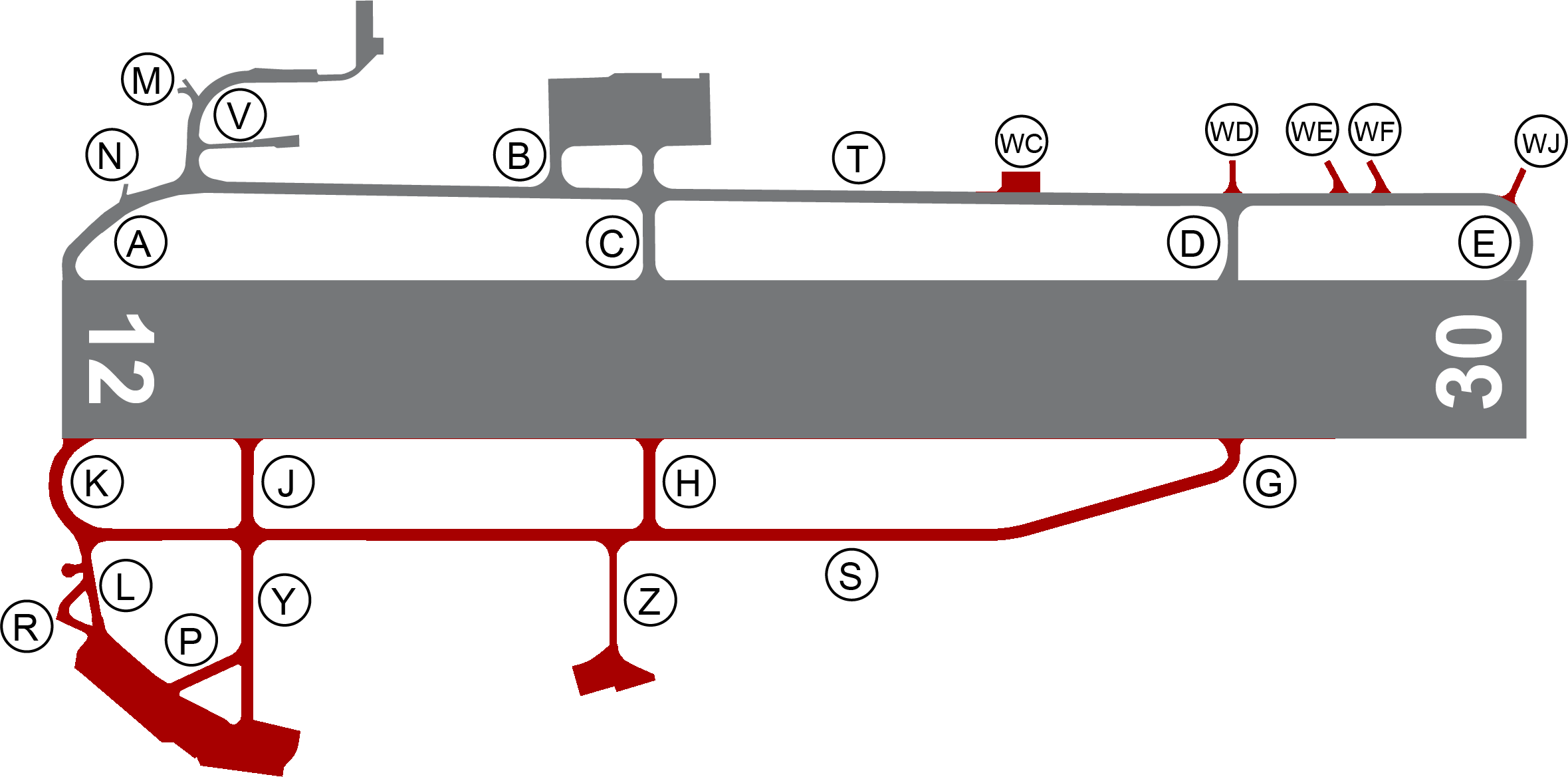
## Ground layout
[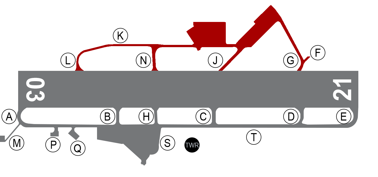](https://wiki.vatsim-scandinavia.org/uploads/images/gallery/2023-07/hltrunway.png)
- Main apron is located south of the runway next to taxiways B and H
- General aviation aircraft can park on the main apron General Aviation Parking Area
- Medical helicopter base is located at Q
Military apron is located north of runway 03/21
### Runways
Rovaniemi is equipped with one runway 03/21. The preferred runway is considered to be runway 03 for departures and runway 21 for arrivals.
Civil aviation must use runway 21 as the primary landing runway at night 2000-0500 UTC (1900-0400 UTC).
Take-offs from the runway intersections can be performed upon the pilot's request the traffic situation permitting.
### Currently available stands
### Stand restrictions and push back
[](https://wiki.vatsim-scandinavia.org/uploads/images/gallery/2023-07/screenshot-2023-07-28-at-18-17-06.png)
🔵 Code E aeroplanes 🔴 Code F aeroplanes
---
When stand 5B is occupied by a code F aeroplane, stands 3 to 5 and 13 to 15 shall be clear of traffic.
#### Code E and F aeroplanes
Code
ICAO
Aircraft type
Wingspan M
🔴 F
A388
Airbus A380-800
79.8
🔴 F
A124
Antonov AN-124-100
73.3
🔴 F
B748
Boeing 747-8
68.5
🔴 F
C5M
Lockheed C-5 Super Galaxy
67.9
🔵 E
B77W, B77L
Boeing 777-300ER, -200LR, -F
64.8
🔵 E
A359, A35K
Airbus A350-900, A350-1000
64.75
🔵 E
B744
Boeing 747-400
64.44
🔵 E
A345, A346
Airbus A340-500, -600
63.45
🔵 E
B772, B773
Boeing 777-300, -200
60.93
🔵 E
A332, A333, A342, A343
Airbus A330-200, -300, Airbus A340-200, -300
60.3
🔵 E
B788, B789, B78X
Boeing Dreamliner 787-8, 787-9, 787-10
60.12
🔵 E
IL96
Iljushin IL-96
60.11
🔵 E
B742, B743
Boeing 747-200, -300
59.6
#### Push back procedures
Stands
Push back procedure
3B, 4B, 5B, 6B, 6C, 8B, 13, 14 and 16
Push back is normally not required but provided by pilot request
1, 2, 3, 4, 5, 6, 7, 8, 9
Push back is required
7B, 8C, 23
No push back
## En-route clearance
Please, do not include the SID in your flight plan route.
By default the local tower controller will give clearance to requested cruise flight level.
### Departure with SID:
Fastair 312, cleared to Helsinki, runway 21, direct Renvi, flight level 350, squawk 5542
Fastair 312, selvä Helsinkiin, kiitotie 21, lähdöstä suoraan Renvi, lentopinta 350, koodaa 5542
## Approach
Please, do not include the STAR in your flight plan route.
Runway 21 is the only runway with an **ILS approach system**. This makes runway 21 the preferred runway during Low Visibility Operations.
- **ILS Z approach** is used for RNAV capable aircraft
- **ILS Y approach** is used for non-RNAV aircraft (based on VOR navigation)
When approaching runway 03, pilots may expect to be cleared for RNP approach.
Arriving aircraft may be cleared for the approach already on initial contact with the local controller. Please be ready to copy any clearance and instructions.
### Phraseology example:
- On initial contact with approach control, please include the following:
- Call sign
- Current flight level
- Assigned flight level
- Aircraft type (and wake turbulence category if necessary)
- Received ATIS broadcast
- Other restrictions given by previous controller
👨✈️
Rovaniemi tower, Golden 332, passing flight level 202 for flight level 100, Airbus 320, information E
Rovaniemen torni, Golden 332, läpäisen lentopinnan 202 lentopinnalle 100, Airbus 320, tiedotus E
🎧
Golden 332, Rovaniemi tower, radar contact. Continue descent to 2500 feet, qnh 1011, cleared RNP approach runway 03, right circuit, number 1 in traffic. Report on final approach course
Golden 332, Rovaniemen torni, tutka yhteys, jatka laskeutumista 2500 jalkaan, qnh 1011, selvä RNP lähestymiseen kiitotie 03, oikea kierros, vuoro yksi, ilmoita loppulähestymissuunnassa
👨✈️
Descend 2500 feet, qnh 1011, cleared RNP approach runway 03, right circuit, wilco, Golden 332
Jatkan laskeutumista 2500 jalkan, qnh 1011, selvä RNP lähestymiseen kiitotie 03, oikea kierros, ilmoitan, Golden 332
## Operations in Low Visibility Conditions
Runways 03 and 21 are approved for Low Visibility Procedures for Take-offs (LVPTO).
- LVPTO is used when the RVR value is 550 M or less.
Runway 21 is approved for ILS CAT II approaches. The approach procedure has the following minimas OCA (H):
- Category A: 688 (79)
- Category B: 699 (90)
- Category C: 712 (103)
- Category D: 727 (118)
There is also LPV approaches available for both runways (Lateral Precision with Vertical Guidance Approach). See the [RNP approach charts](https://aip.intor.fi/ad/efro.html) for more information.
### LVP initiation
Low Visibility Procedures for all air traffic will become effective when the RVR value decreases to **550 M**.
## Medical helicopter
Note! The base of medical helicopter is located at the airport. The call sign of the medical helicopter is “Finnhems”.
- Check [👨🏻✈️ HEMS Pilot Procedures](https://wiki.vatsim-scandinavia.org/books/special-procedures/page/hems-pilot-procedures) for more information.
# 🔵 EFTP - Tampere-Pirkkala
[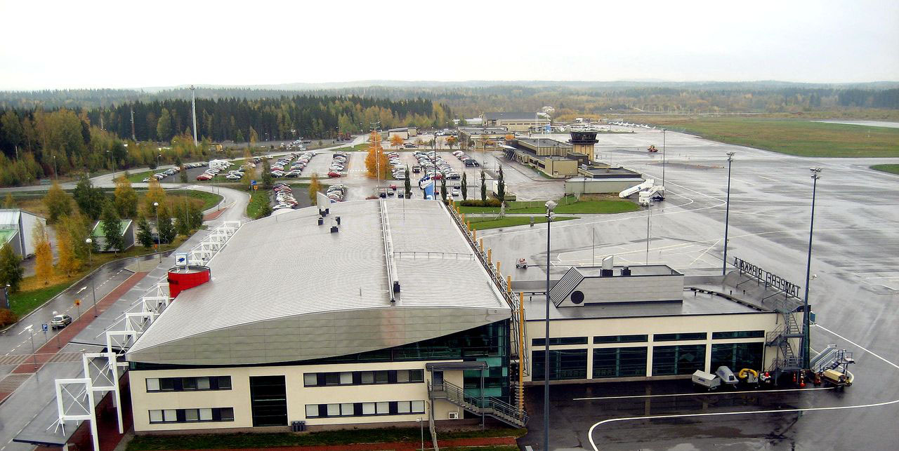](https://wiki.vatsim-scandinavia.org/uploads/images/gallery/2023-07/eftp.jpg)
Tampere-Pirkkala Airport is located in the town of Pirkkala, approximately 13 kilometers south-west of the city of Tampere. As the **third busiest airport in Finland** according to passenger count, it serves as a crucial transport hub, offering both domestic and international flights. Finnair, Air Baltic and Ryanair are the most active airlines in Pirkkala.
The airport is split into two terminals. Terminal 2 is not in use.
Tampere-Pirkkala Airport sees a diverse array of aircraft, from small private planes to larger commercial jets. Notably, it is also the home base for the Finnish Air Force's Satakunta Air Command, making it a shared civil-military aerodrome.
IATA
ICAO
Charts
TMP
EFTP
[ChartFox - EFTP](https://chartfox.org/EFTP)
## ATC positions
Tampere-Pirkkala is a controlled airport with aerodrome control- and approach control service. This service can be combined (tower-radar), or separate. Pirkkala Ground and Arrival positions are opened only when necessary due high traffic levels.
Logon code
Call sign
Frequency
Responsibilities
EFTP\_GND
PIRKKALA GROUND
124.275
En-route clearance, ground movement
EFTP\_TWR
PIRKKALA TOWER
118.700
Ground movement, Pirkkala Control Zone
EFTP\_R\_TWR
PIRKKALA TOWER
118.700
Ground movement, Pirkkala Control Zone and Terminal Area
EFTP\_APP
PIRKKALA RADAR
126.200
Tampere Terminal Area
EFTP\_R\_APP
PIRKKALA ARRIVAL
120.250
Tampere Terminal Area - arrivals below 5000 FT
## Ground layout
[](https://wiki.vatsim-scandinavia.org/uploads/images/gallery/2023-07/yarrunway.png)
- Main apron is located north of the runway next to taxiways H and G
- General aviation aircraft can park on the main apron General Aviation Parking Area, or on Apron 3, which is located next to taxiway P
- Medical helicopter base is located east of taxiway G
There is a military apron south of runway 06/24
Taxi routes for the aircraft with code letter E and F are presented in Finland AIP on the AGMC chart.
### Runways
Tampere-Pirkkala is equipped with one runway 06/24. The preferred runway is considered to be runway 24 for departures and runway 06 for arrivals.
Civil aviation must use runway 06 as the primary landing runway at night 2000-0500 UTC (1900-0400 UTC) and runway 24 as the primary take-off runway, unless otherwise dictated by air traffic safety.
### Currently available stands
### Stand restrictions
- A stands are used for passenger flights
- B stands may be used for General Aviation and flights with no passengers
- Stand B1 (and APN 4) can accomodate Code E or F aeroplanes:
[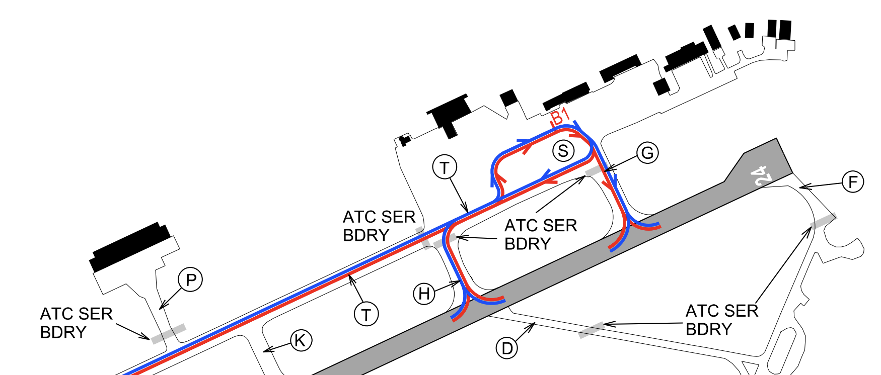](https://wiki.vatsim-scandinavia.org/uploads/images/gallery/2023-07/screenshot-2023-07-28-at-21-57-55.png)
🔵 Code E aeroplanes 🔴 Code F aeroplanes
---
When stand B1 is occupied by a Code E or F aeroplane, stands A5, B2 and B3 are also blocked. Additionaly taxiway S cannot be used by other traffic.
#### Code E and F aeroplanes
Code
ICAO
Aircraft type
Wingspan M
🔴 F
A388
Airbus A380-800
79.8
🔴 F
A124
Antonov AN-124-100
73.3
🔴 F
B748
Boeing 747-8
68.5
🔴 F
C5M
Lockheed C-5 Super Galaxy
67.9
🔵 E
B77W, B77L
Boeing 777-300ER, -200LR, -F
64.8
🔵 E
A359, A35K
Airbus A350-900, A350-1000
64.75
🔵 E
B744
Boeing 747-400
64.44
🔵 E
A345, A346
Airbus A340-500, -600
63.45
🔵 E
B772, B773
Boeing 777-300, -200
60.93
🔵 E
A332, A333, A342, A343
Airbus A330-200, -300, Airbus A340-200, -300
60.3
🔵 E
B788, B789, B78X
Boeing Dreamliner 787-8, 787-9, 787-10
60.12
🔵 E
IL96
Iljushin IL-96
60.11
🔵 E
B742, B743
Boeing 747-200, -300
59.6
## En-route clearance
Please, do not include the SID in your flight plan route.
By default the local tower controller will give clearance to requested cruise flight level.
### Departure with SID:
🎧
Fastair 312, cleared to Turku, runway 24, Nebab 3E departure, flight level 100, squawk 5542
Fastair 312, selvä Turkuun, kiitotie 24, Nebab 3E lähtöreitti, lentopinta 100, koodaa 5542
### Departure with direct route:
🎧
Fastair 312, cleared to Turku, runway 24, direct Nebab, flight level 100, squawk 5542
Fastair 312, selvä Helsinkiin, kiitotie 21, lähdöstä suoraan Nebab, lentopinta 100, koodaa 5542
## Approach
Please, do not include the STAR in your flight plan route.
Runway 24 is the only runway with an **ILS approach system**. This makes runway 24 the preferred runway during Low Visibility Operations.
- **ILS Z approach** is used for RNAV capable aircraft
- **ILS Y approach** is used for non-RNAV aircraft (based on VOR navigation)
When approaching runway 06, pilots may expect to be cleared for RNP approach.
Arriving aircraft may be cleared for the approach already on initial contact with the local controller. Please be ready to copy any clearance and instructions.
### Phraseology example:
- On initial contact with approach control, please include the following:
- Call sign
- Current flight level
- Assigned flight level
- Aircraft type (and wake turbulence category if necessary)
- Received ATIS broadcast
- Other restrictions given by previous controller
👨✈️
Pirkkala tower, Golden 332, passing flight level 204 for flight level 100, Airbus 320, information F
Pirkkalan torni, Golden 332, läpäisen lentopinnan 204 lentopinnalle 100, Airbus 320, tiedotus F
🎧
Golden 332, Pirkkala tower, radar contact. Continue descent to 2700 feet, qnh 1011, cleared ILS-Z approach runway 24, left circuit, number 1 in traffic. For information, next 20 miles below flight level 95 uncontrolled airspace.
Golden 332, Pirkkalan torni, tutka yhteys, jatka laskeutumista 2700 jalkaan, qnh 1011, selvä ILS-Z lähestymiseen kiitotie 24, vasen kierros, vuoro yksi, tiedoksi seuraavat 20 mailia alle lentopinnan 95 valvomatonta ilmatilaa.
👨✈️
Descend 2700 feet, qnh 1011, cleared ILS-Z approach runway 24, left circuit, roger, Golden 332
Jatkan laskeutumista 2700 jalkan, qnh 1011, selvä ILS-Z lähestymiseen kiitotie 24, vasen kierros, selvä, Golden 332
## Operations in Low Visibility Conditions
Runways 06 and 24 are approved for Low Visibility Procedures for Take-offs (LVPTO).
- LVPTO will be taken to effect when the RVR value is 550 M or less.
- Pilots will be informed by ATIS or ATC: "LOW VISIBILITY TAKE OFF PROCEDURES IN OPERATION"
- Only one aircraft is allowed on the manoeuvring area when LVPTO is in effect
Low Visibility Procedures for Take-off are not allowed below **RVR 300 meters** due to the absence of RCLL.
Tampere-Pirkkala airport is only equipped with ILS CAT I approach for runway 24. The approach minimas are OCA (H):
- Category A: 524 (157)
- Category B: 534 (167)
- Category C: 546 (179)
- Category D: 559 (192)
There is also LPV approaches available for both runways (Lateral Precision with Vertical Guidance Approach). See the [RNP approach charts](https://aip.intor.fi/ad/eftp.html) for more information.
## VFR local procedures
**Preferred VFR cicuit south of aerodrome:**
[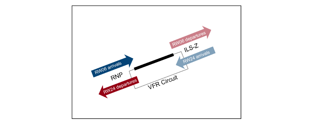](https://wiki.vatsim-scandinavia.org/uploads/images/gallery/2023-05/8217b8e3cca02989bf1b970f88b876ac.png)
When cleared to leave or enter the Control Zone via PUPPA Visual Reporting Point, pilots shall follow the published VFR route within the Control Zone:
[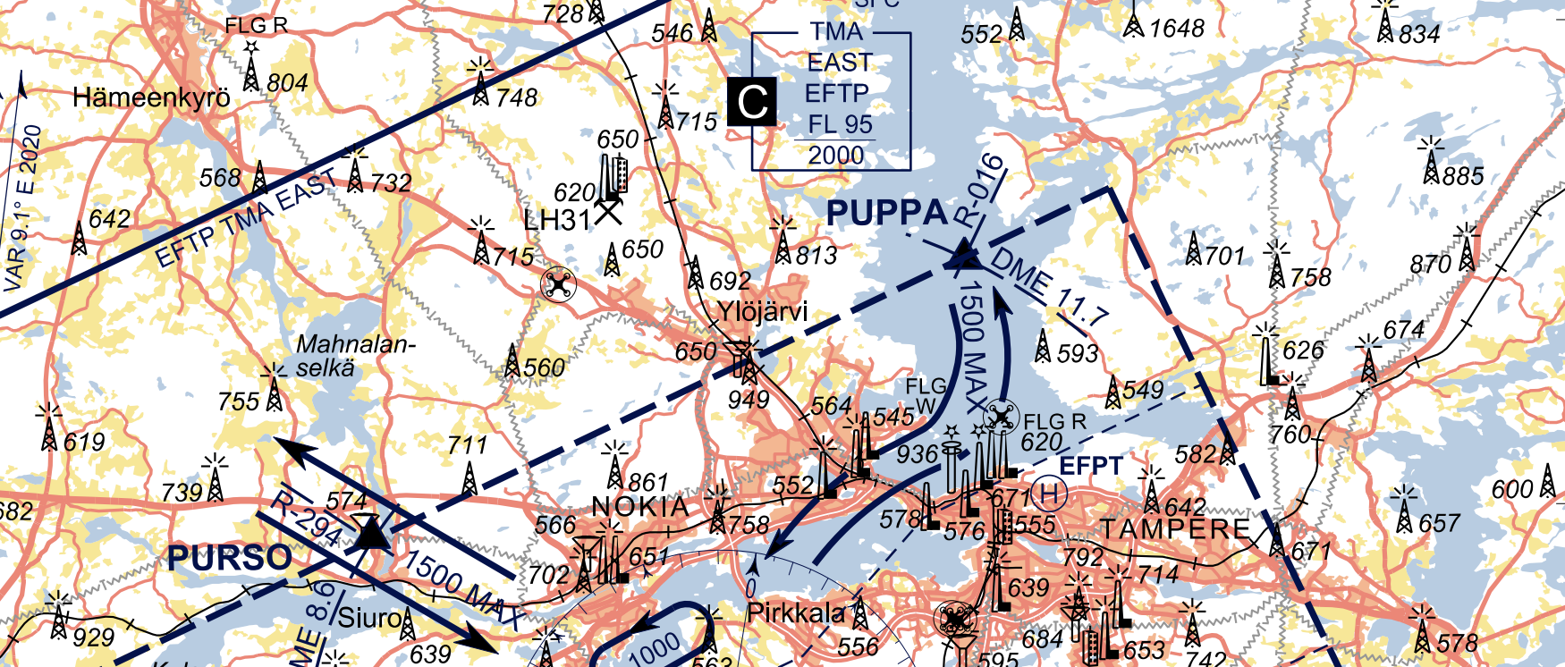](https://wiki.vatsim-scandinavia.org/uploads/images/gallery/2023-07/screenshot-2023-07-30-at-13-05-02.png)
## Medical helicopter
Note! The base of medical helicopter is located at the airport. The call sign of the medical helicopter is “Finnhems”.
- Check [👨🏻✈️ HEMS Pilot Procedures](https://wiki.vatsim-scandinavia.org/books/special-procedures/page/hems-pilot-procedures) for more information.
# 🔵 EFTU - Turku
[](https://wiki.vatsim-scandinavia.org/uploads/images/gallery/2023-07/eftu-banner.jpg)
Turku Airport is the **fourth busiest airport in Finland** according to passenger numbers, located approximately 8 kilometers north of Turku city center. The airport is an integral part of the Scandinavian and Baltic aviation network and serves as an important hub for both commercial and private flights. Turku airport is highly accessible and strategically positioned.
One should note that Turku Airport is open 24 hours a day and offers ATC services during its operational hours. It is surrounded by flat terrain, and pilots should be aware of the weather conditions, especially during the winter months when heavy snow can be expected.
IATA
ICAO
Charts
TKU
EFTU
[ChartFox - EFTU](https://chartfox.org/EFTU)
## ATC positions
Turku is a controlled airport with aerodrome control- and approach control service. This service can be combined (tower-radar), or separate.
Logon code
Call sign
Frequency
Responsibilities
EFTU\_TWR
TURKU TOWER
118.300
Ground movement, Turku Control Zone
EFTU\_R\_TWR
TURKU TOWER
118.300
Ground movement, Turku Control Zone & Terminal Area
EFTU\_APP
TURKU RADAR
120.475
Turku Terminal Area
## Ground layout
[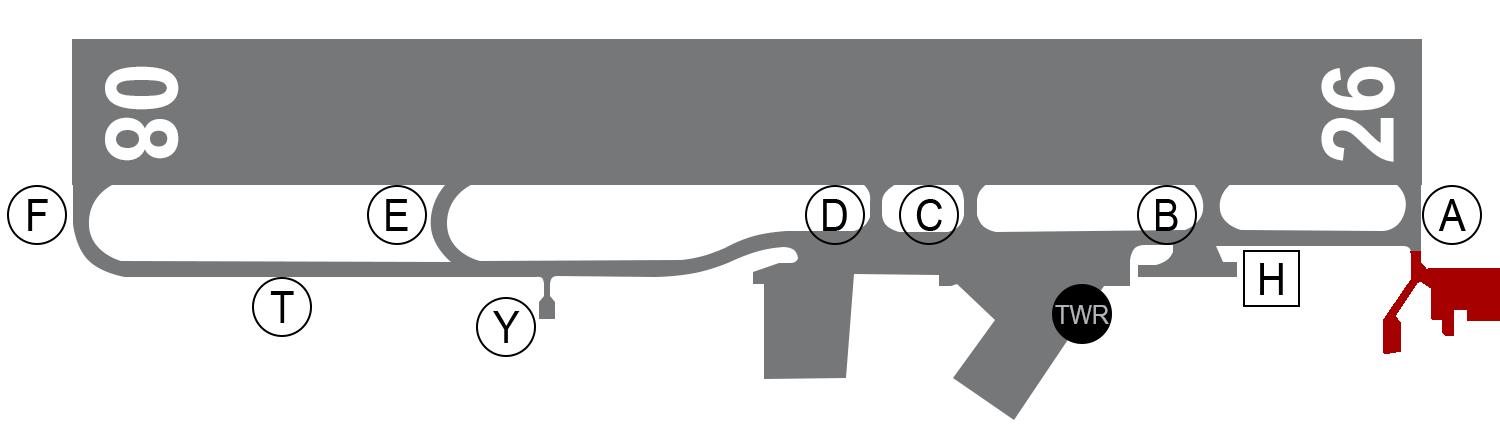](https://wiki.vatsim-scandinavia.org/uploads/images/gallery/2023-07/xt0runway.png)
- The main apron serving passenger airlines is located next to the Control Tower
- Cargo flights are usually parked on the cargo apron next to taxiway D
- General aviation aircraft are parked on the Apron next to taxiway Y or B
- Medical helicopter base is located next to taxiway B south of the main taxiway
Frontier Guard apron is located next to taxiway A. There is also one hangar for Air Force QRA missions.
### Runways
Turku is equipped with one runway 08/26. The preferred runway is considered to be runway 08.
### Currently available stands
### Stand restrictions
- Stands 5B and 8 can accomodate Code E and F aeroplanes (see table below)
- Stands 4, 5, 6 and 7 can accomodate Jet aircraft up to A321 / B739
- Cargo aircraft are parked on stands 9, 10, 12 and 12
[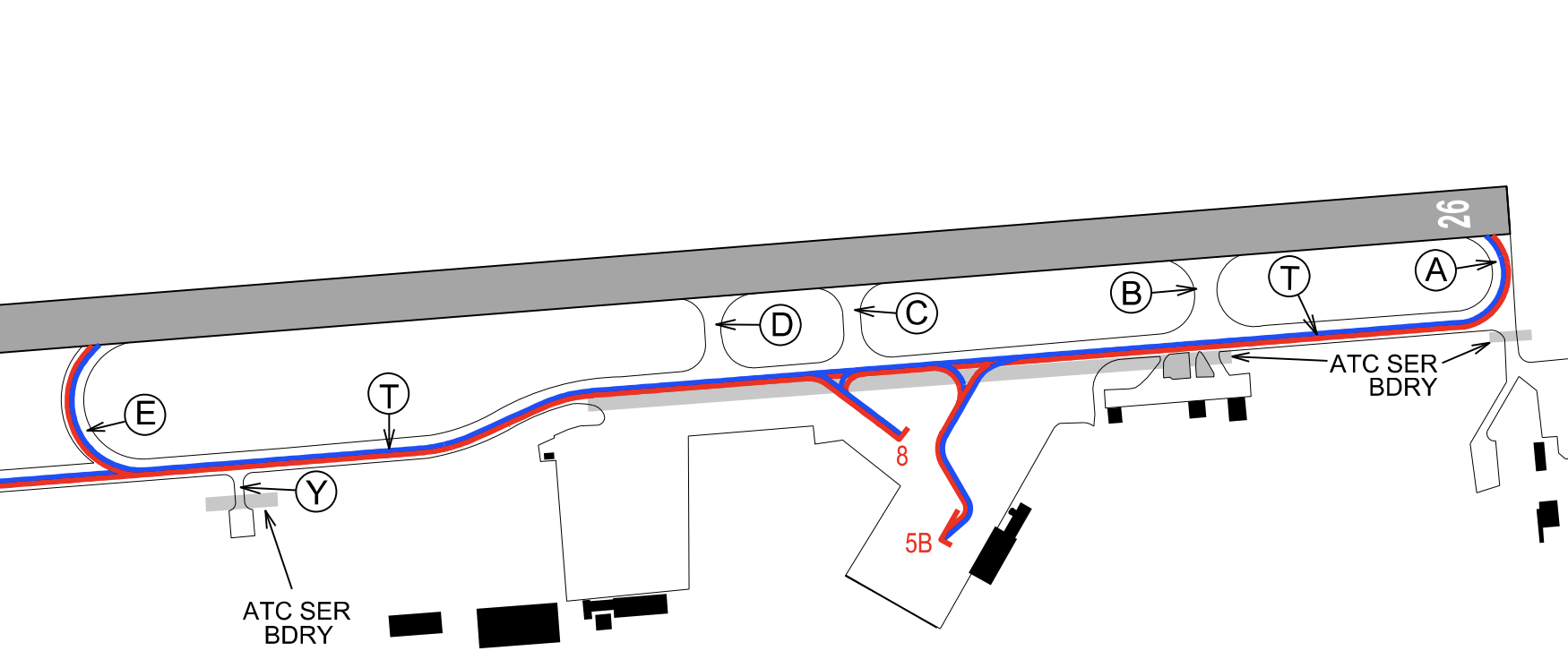](https://wiki.vatsim-scandinavia.org/uploads/images/gallery/2023-07/screenshot-2023-07-28-at-21-10-36.png)
🔵 Code E aeroplanes 🔴 Code F aeroplanes
When stand 5B is occupied, stands 5, 6 and 7 shall not be in use. Stand 5B is only used for Code E or F aeroplanes.
---
Code
ICAO
Aircraft type
Wingspan M
🔴 F
A388
Airbus A380-800
79.8
🔴 F
A124
Antonov AN-124-100
73.3
🔴 F
B748
Boeing 747-8
68.5
🔴 F
C5M
Lockheed C-5 Super Galaxy
67.9
🔵 E
B77W, B77L
Boeing 777-300ER, -200LR, -F
64.8
🔵 E
A359, A35K
Airbus A350-900, A350-1000
64.75
🔵 E
B744
Boeing 747-400
64.44
🔵 E
A345, A346
Airbus A340-500, -600
63.45
🔵 E
B772, B773
Boeing 777-300, -200
60.93
🔵 E
A332, A333, A342, A343
Airbus A330-200, -300, Airbus A340-200, -300
60.3
🔵 E
B788, B789, B78X
Boeing Dreamliner 787-8, 787-9, 787-10
60.12
🔵 E
IL96
Iljushin IL-96
60.11
🔵 E
B742, B743
Boeing 747-200, -300
59.6
## En-route clearance
Please, do not include the SID in your flight plan route.
By default the local tower controller will give clearance to requested cruise flight level.
### Departure with SID:
Please, do not include the STAR in your flight plan route.
Runway 26 is the only runway with an **ILS approach system**. This makes runway 26 the preferred runway during Low Visibility Operations.
- **ILS approach** is used for RNAV capable aircraft
- Visual approaches are used for Non-RNAV capable aircraft
When approaching runway 08, pilots may expect to be cleared for **RNP approach**.
Arriving aircraft may be cleared for the approach already on initial contact with the local controller. Please be ready to copy any clearance and instructions.
### Phraseology example:
- On initial contact with approach control, please include the following:
- Call sign
- Current flight level
- Assigned flight level
- Aircraft type (and wake turbulence category if necessary)
- Received ATIS broadcast
- Other restrictions given by previous controller
👨✈️
Turku tower, Quality 4KU, flight level 100, Boeing 738, information B
Turun torni, Quality 4KU, lentopinnalla 100, Boeing 738, tiedotus B
🎧
Quality 4KU, Turku tower, radar contact, continue descent to 2200 feet, QNH 1010, cleared ILS Z approach runway 26, report established on localizer, for information next 15 miles below flight level 95 uncontrolled airspace
Quality 4KU, Turun torni, tutkayhteys, jatka laskeutumista 2200 jalkaan, QNH 1010, selvä ILS Z lähestymiseen kiitotie 26, ilmoita suuntasäteellä, tiedoksi seuraavat 15 mailia alle lentopinnan 95 valvomatonta ilmatilaa
👨✈️
Continue descent to 2200 feet, QNH 1010, cleared ILS Z approach runway 26, wilco, Quality 4KU
Jatkan laskeutumista 2200 jalkaan, QNH 1010, selvä ILS Z lähestymiseen kiitotie 26, ilmoitan, Quality 4KU
## Operations in Low Visibility Conditions
Runways 08 and 26 are approved for Low Visibility Procedures for Take-offs (LVPTO).
- Procedures will be in force when the RVR value is 550 M or less.
- Pilots will be informed by ATIS or ATC: "LOW VISIBILITY TAKE OFF PROCEDURES IN OPERATION"
- Only one aircraft is allowed on the manoeuvring area when LVPTO is in effect
Low Visibility Procedures for Take-off are not allowed below **RVR 300 meters** due to the absence of RCLL.
Turku airport is only equipped with ILS CAT I approach for runway 26. The approach minimas are OCA (H):
- Category A: 300 (159)
- Category B: 310 (169)
- Category C: 322 (181)
- Category D: 335 (194)
There is also LPV approaches available for both runways (Lateral Precision with Vertical Guidance Approach). See the [RNP approach charts](https://aip.intor.fi/ad/eftu.html) for more information.
## Medical helicopter
Note! The base of medical helicopter is located at the airport. The call sign of the medical helicopter is “Finnhems”.
- Check [👨🏻✈️ HEMS Pilot Procedures](https://wiki.vatsim-scandinavia.org/books/special-procedures/page/hems-pilot-procedures) for more information.
## Frontier Guard flights
### General information
Two Frontier Guard aircraft have their base at Turku airport. These aircraft are parked on the Frontier Guard apron south of runway 26 threshold.
ICAO call sign
Radio call sign
Aircraft type
SSR code
FNG 8
FINNGUARD 8
Dornier 228 (D228)
0010
FNG 100
FINNGUARD 100
AS-332 Super Puma (AS32) helicopter
0011
Frontier Guard pilots shall select the **predetermined transponder code** according to the table above prior contacting Turku Tower.
### Flight planning
Frontier Guard flights are usually operated under **VFR rules** when weather allows. Departure and arrival can be peformed directly from/to apron, or on the active runway, whichever is preferred.
Maritime patrol flights shall include ***OPR/FNG RMK/MARITIME PATROL*** in the flight plan.
- The above information denotes a flight by the Guard Squadron near the maritime borders of Finland.
- The route section can include lighthouses or islands to better represent the route of the flight
- In IMC conditions, the route usually consists of RNAV waypoints or coordinates to represent the planned route as close as possible
# 🟠 Aerodromes with AFIS
[](https://wiki.vatsim-scandinavia.org/uploads/images/gallery/2023-07/afis-working.jpg)
**Aerodrome Flight Information Service**
---
Aerodromes with AFIS service in Finland are:
- EFET - Enontekiö
- EFKI - Kajaani
- EFMI - Mikkeli
- EFSA - Savonlinna
- EFSI - Seinäjoki
When AFIS is provided, the controller is connected with **EFXX\_I\_TWR** logon code.
Pilots shall be in contact with AFIS Officers (AFISO) when operating on the maneouvering area or when flying within the FIZ Upper and FIZ Lower airspaces.
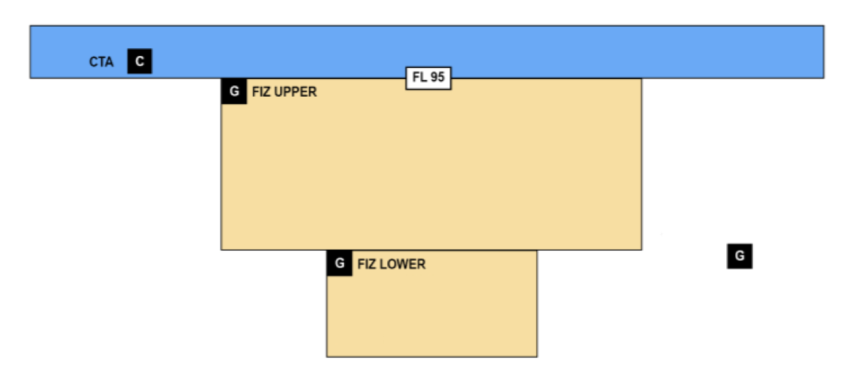## What is AFIS?
AFIS is the term used to describe the provision of information useful for the safe and efficient conduct of aerodrome traffic at those aerodromes where the provision of aerodrome control service is not justified or is not justified on a 24-hour basis.
**AFIS is not an air traffic control unit!** An AFIS unit will provide flight information service and alerting service to aerodrome traffic.
AFIS Officers (AFISO) will relay IFR en-route clearances from Area Control, pass information and warnings to pilots. Pilots are therefore wholly responsible for maintaining proper spacing in conformity with the rules of the air.
- This means that pilots shall report their intentions to AFIS instead of receiving clearances
## Phraseology examples
### Start-up procedures
AFIS in Finland will control start-up.
👨✈️
SAVONLINNA INFORMATION, GAO 332, REQUEST START-UP, INFORMATION CHARLIE
SAVONLINNAN TIEDOTUS, GAO 332, PYYDÄN KÄYNNISTÄÄ, TIEDOTUS CHARLIE
🎧
GAO 332, SAVONLINNA INFORMATION, (ATC ADVICES) START-UP APPROVED
GAO 332, SAVONLINNAN TIEDOTUS, SAAT KÄYNNISTÄÄ
Note! Authorization for possible pushback shall be obtained from the AFIS unit.
👨✈️
GAO 332, REQUEST PUSHBACK
GAO 332, PYYDÄN TYÖNTÖÄ
🎧
GAO 332, PUSHBACK AT OWN DISCRETION
GAO 332, TYÖNNÄ HARKINTASI MUKAAN
### IFR en-route clearance
🎧
GAO 332, HELSINKI CONTROL CLEARS TO HELSINKI, FLIGHT PLAN ROUTE, FLIGHT LEVEL 220, SQUAWK 3466
GAO 332, HELSINGIN ALUE SELVITTÄÄ HELSINKIIN, LENTOSUUNNITELMAN MUKAINEN REITTI, LENTOPINTA 220, KOODAA 3466
👨✈️
CLEARED TO HELSINKI, FLIGHT PLAN ROUTE, FLIGHT LEVEL 220, SQUAWK 3466, GAO 332
SELVÄ HELSINKIIN, LENTOSUUNNITELMAN MUKAINEN REITTI, LENTOPINTA 220, KOODAAN 3466, GAO 332
🎧
GAO 332, (THAT IS) CORRECT
GAO 332, OIKEIN
### Taxi
👨✈️
GAO 332, READY TO TAXI, STAND 2
GAO 332, VALMIINA RULLAAMAAN, PAIKKA 2
🎧
GAO 332, NO REPORTED TRAFFIC
GAO 332, EI TIEDOSSA OLEVAA LIIKENNETTÄ
👨✈️
TAXIING TO HOLDING POINT ALPHA RUNWAY 12, GAO 332
RULLAAN ODOTUKSEEN ALPHA KIITOTIE 12, GAO 332
### Take-off
🎧
GAO 332, REPORT READY
GAO 332, ILMOITA KUN VALMIS
👨✈️
GAO 332, READY FOR DEPARTURE
GAO 332, VALMIINA LÄHTÖÖN
🎧
GAO 332, WIND CALM, NO REPORTED TRAFFIC RUNWAY 12
GAO 332, TUULI TYYNTÄ, EI TIEDOSSA OLEVAA LIIKENNETTÄ KIITOTIE 12
GAO 332, HOLDING SHORT RUNWAY 12
GAO 332, PYSYN SELVÄSTI EROSSA KIITOTIE 12
### Climb
Normally the handoff from AFIS to Area Control occurs **3 minutes** after departure, or prior to passing FL 95.
🎧
GAO 332, NEXT FREQUENCY IS 132.325, YOU MAY LEAVE THIS FREQUENCY
GAO 332, SEURAAVA TAAJUUS ON 132.325, VOIT JÄTTÄÄ TÄMÄN TAAJUUDEN
👨✈️
132.325, GAO 332
### Approach
👨✈️
SAVONLINNA INFORMATION, GAO 332, PASSING FLIGHT LEVEL 170, DESCENDING TO FLIGHT LEVEL 100, INFORMATION CHARLIE
SAVONLINNAN TIEDOTUS, GAO 332, LÄPI LENTOPINTA 170, LASKEUDUN PINNALLE 100, TIEDOTUS CHARLIE
🎧
GAO 332, SAVONLINNA INFORMATION, NO REPORTED TRAFFIC, PREFERRED RUNWAY 12, INFORMATION DELTA, QNH 1010, RUNWAY 12 SURFACE CONDITION CODE 4, DRY SNOW, 1 MILLIMETER
GAO 332, SAVONLINNAN TIEDOTUS, EI TIEDOSSA OLEVAA LIIKENNETTÄ, SUOSITELTAVA KIITOTIE 12, TIEDOTUS DELTA, QNH 1010, KIITOTIE 12 KIITOTIEOLOSUHTEET KOODI 4, KUIVAA LUNTA, 1 MILLIMETRI
GAO 332, REPORT ESTABLISHED ON LOCALIZER
GAO 332, ILMOITA SUUNTASÄTEESSÄ
👨✈️
WILCO, GAO 332
ILMOITAN, GAO 332
- - - - -
👨✈️
GAO 332, ESTABLISHED ON (ILS) LOCALIZER RUNWAY 12
GAO 332, (ILS) SUUNTASÄTEESSÄ KIITOTIE 12
### Landing
🎧
GAO 332, NO REPORTED TRAFFIC RUNWAY 12, WIND 140 DEGREES 7 KNOTS, VARIABLE BETWEEN 100 AND 170 DEGREES, MINIMUM 3 KNOTS, MAXIMUM 17 KNOTS
GAO 332, EI TIEDOSSA OLEVAA LIIKENNETTÄ KIITOTIE 12, TUULI 140 ASTETTA 7 SOLMUA, VAIHTELEE VÄLILLÄ 100 JA 170 ASTETTA, MINIMI 3 SOLMUA, MAKSIMI 17 SOLMUA
O-ME, RUNWAY 30 OCCUPIED
O-ME, KIITOTIE 30 KÄYTÖSSÄ
👨✈️
O-ME, WILL MAKE THREE-SIXTY RIGHT
O-ME, TEEN KOLMEKUUSIKYMMENTÄ OIKEALLE
### VFR flight
👨✈️
SAVONLINNA INFORMATION, OH-CME, CESSNA 172, 15 MILES NORTH OF AIRFIELD, 1800 FEET, INFORMATION CHARLIE, FOR LANDING
SAVONLINNAN TIEDOTUS, OH-CME, CESSNA 172, 15 MAILIA KENTÄSTÄ POHJOISEEN, 1800 JALKAA, TIEDOTUS CHARLIE, LASKUA VARTEN
🎧
O-ME, SAVONLINNA INFORMATION, RIGHT CIRCUIT RUNWAY 30, QNH 1010, TRAFFIC FINNAIR ATR 72 ON 7 MILES FINAL RUNWAY 30
O-ME, SAVONLINNAN TIEDOTUS, OIKEA KIERROS KÄYTÖSSÄ KIITOTIE 30, QNH 1010, LIIKENNE FINNAIR ATR 72 7 MAILIN LOPPUOSALLA KIITOTIE 30
👨✈️
O-ME, VIA HANHI JOINING RIGHT DOWNWIND RUNWAY 30, 1100 FEET, QNH 1010
O-ME, HANHEN KAUTTA LIITYTÄÄN OIKEAAN MYÖTÄTUULEEN KIITOTIE 30, 1100 JALKAA, QNH 1010
🎧
SAVONLINNA
SAVONLINNA
- - - - -
👨✈️
O-ME, HANHI INBOUND, FINNAIR ATR 72 IN SIGHT, JOINING FINAL RUNWAY 30 AS NUMBER 2
O-ME, HANHI SISÄÄN, FINNAIR ATR 72 NÄKYVISSÄ, LIITYTÄÄN LOPPUOSALLE KIITOTIE 30 VUOROLLA 2
🎧
O-ME, REPORT FINAL
O-ME, ILMOITA LOPPUOSA
👨✈️
WILCO, O-ME
ILMOITAN, O-ME
- - - - -
👨✈️
O-ME, FINAL RUNWAY 30
O-ME, LOPPUOSA KIITOTIE 30
🎧
O-ME, WIND CALM, NO REPORTED TRAFFIC RUNWAY 30
O-ME, TUULI TYYNTÄ, EI TIEDOSSA OLEVAA LIIKENNETTÄ KIITOTIE 30
👨✈️
O-ME, WILL LAND RUNWAY 30
O-ME, SUORITAN LASKUN KIITOTIELLE 30
# 🔴 V-LARA Airspace Reservation
[](https://wiki.vatsim-scandinavia.org/uploads/images/gallery/2025-08/lara.jpg)
### Record of Amendments
Version
Issue Date
Reason for Change
0.1 d1
28 DEC 2024
Initial draft
0.1
23 JAN 2025
Open beta
1.0
16 JUL 2025
Introduction of multiple FIR support
1.1
12 AUG 2025
New GUI elements. Preparations for EGXX and EGXX clusters.
\* showing only large updates ## V-LARA Booking Client - Pilot Guide
Link to LARA Web Booking Client
[https://lara.lusep.fi/](https://lara.lusep.fi/)
### 1. INTRODUCTION
The V-LARA Web Booking Client can be used to make airspace reservations in Finland on VATSIM network. Pilots or organizations can view all upcoming airspace reservations in Finland and add their own reservations.
It is currently possible to make reservations for all TSA, TRA and Local TRA areas in Finland either for Civil or Military operations. Pilots and organizations are kindly requested to familiarize themselves with the procedures for operations in Reserved Areas (including flight planning and phraseology).
Check the **Basic Use Case** and **Useful Links & Phraseology** at the end of this page!
### 2. LOGIN PAGE
[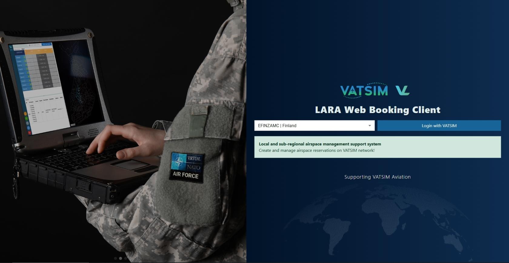](https://wiki.vatsim-scandinavia.org/uploads/images/gallery/2025-07/vlara1.jpg)
When the page loads, you will be automatically shown the login page. The V-LARA application uses VATSIM OAuth2 login for authenticating users. The `PilotView` will be opened automatically after successful authentication.
#### 2.1 LOGIN ERRORS
If the login process fails, the error message will be displayed below the login button.
- Login Failed. If problems presist, please contact your system administrator.
### 3. MAIN PAGE
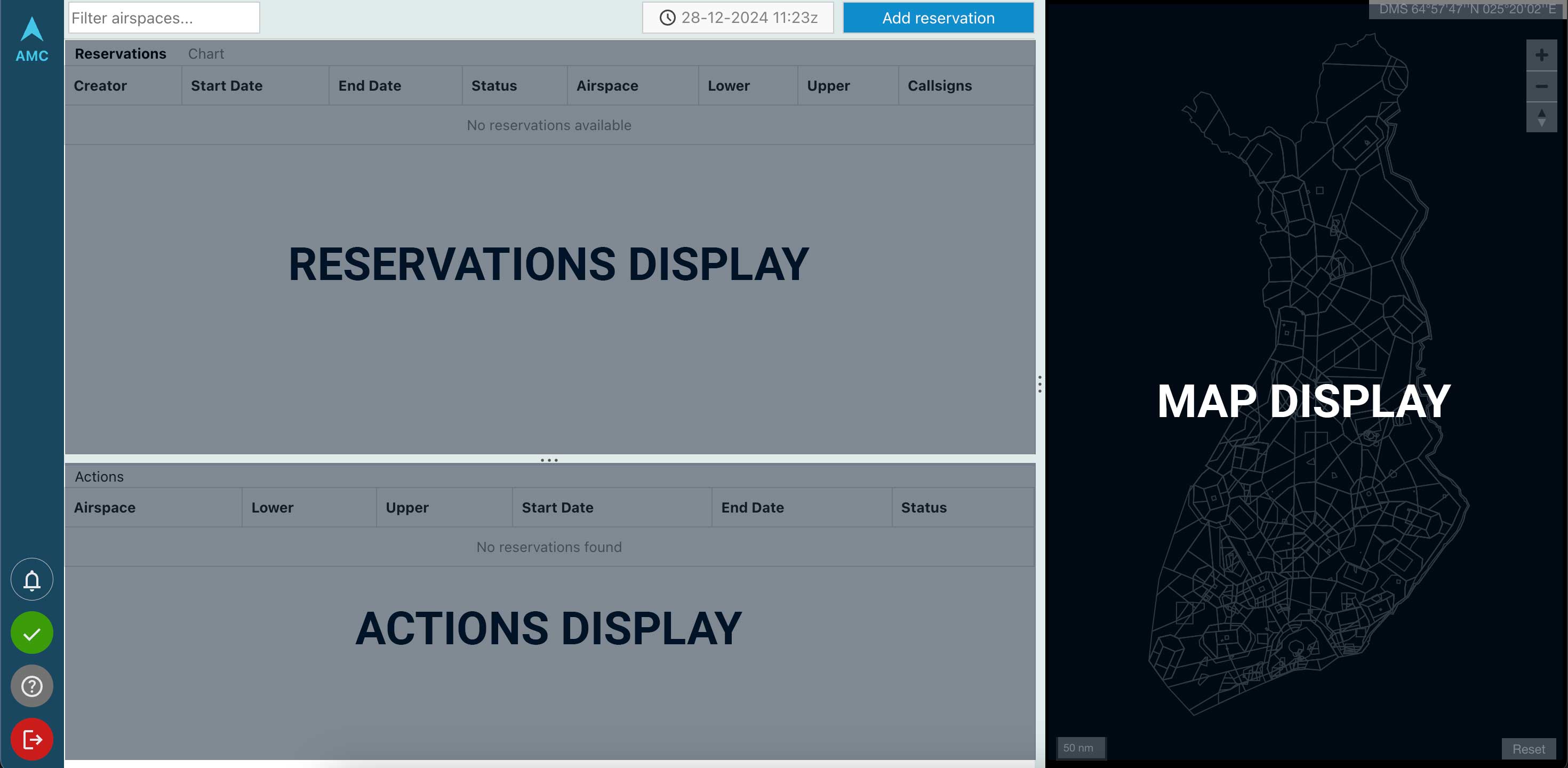The main page is broken up into three main sections: the `Reservations Display`, the `Actions Display`, and the `Map Display`.
The navigator bar on the left has number of buttons for performing actions:
- `Notification Icon` - (currently only in use for AMC/ATC)
- `Status Icon` - displays the connectivity between the Web Client and the server
- `Help Button` - links to this user guide
- `Logout Button` - log the currently logged in user out of V-LARA
### 4. RESERVATION DISPLAY
The reservations are displayed in a simple table to the top left of the screen showing all airspace reservations in Finland. The table is automatically updated without the need for any page refreshes.
The background of the status field is automatically changed to match the reservation’s current status:
- Status RESERVED
- Status PENDING
- Status ACTIVE
- Status CANCELLED
#### 4.1 GANTT CHART
To open the `Gantt Chart`, click on the "Chart" title text on the top of the page.
The Gantt Chart is used for the visualisation of reservations in the LARA Web Client. Areas are represented by rows in the chart and reservations are placed on the chart as rectangular slots at the times they are for.
The time range visible in the chart is displayed on the timescale at the top of the chart.
### 5. ACTIONS DISPLAY
The actions table displays all actions relevant to the user logged in and is updated automatically without the need for a page refresh. To perform an action, click on the row in the table to open the `Reservation Editor` and then click on the button for that action at the bottom of the editor.
Pilots and organizations will only see their own reservations listed in the `Actions Display`. Pilots can edit their reservations up to 30 minutes prior start-time. After that the reservation will go to "Pending" state and only AMC/ATC can make modifications to the reservation.
The background of each row is automatically changed to match the reservation’s current status:
- Status RESERVED (reservation can be edited by pilot)
- Status PENDING (from here on reservation can only be edited by AMC/ATC)
- Status ACTIVE
- Status CANCELLED
If the ACTIVE reservation is ending in less than 10 minutes, the `End Date` field will begin flashing red. If the activity is still ongoing in the reserved area, remember to contact ATC to extend the reservation time. Otherwise the reservation will be automatically CANCELLED once the `End Date` is reached.
### 6. MAP DISPLAY
The map displays boundaries for all reservable airspace blocks in Finland. Additionally the map displays the airspace reservations with the following color coding:
- Status RESERVED (blue outline)
- Status PENDING (orange outline)
- Status ACTIVE (red fill)
- Cancelled reservations are not shown on the map
The map works like any other browser-based map which can be navigated by clicking and dragging the map, and zooming in and out by double-clicking or using the mouse-wheel.
### 7. RESERVATION EDITOR
The `Reservation Editor` is a form which allows users to view, create, edit reservations as well as perform actions such as approving and cancelling reservations.
To open the Reservation Editor, click on a table row in `Actions Display`, or click on the Add reservation -button in the top-menu to start creating a new reservation.
Create only a reservation if intending to use the airspace. The reservations will be visible to ATC in real time.
Pilots can edit their reservations up to 30 minutes prior reservation start time.
#### 7.1 BASIC SECTION
[](https://wiki.vatsim-scandinavia.org/uploads/images/gallery/2025-07/vlara-basic.png)
The basic section of the reservation editor contains fields for displaying and setting the creator, point of contact, and callsigns associated with the reservation editor.
The user creating the reservation is always in charge of the reservation and will be the Point of Contact for AMC/ATC if coordination or changes to the reservation needs to be made.
The callsign editor is a special form field with aids to help create and remove callsigns. To add a callsign, type the callsign and either click somewhere outside of the callsign field, if finished editing, or type a comma (,) to add a callsign and continue editing.
To remove a callsign, click on the x next to the callsign to remove.
#### 7.2 ACTIVITY SECTION
[](https://wiki.vatsim-scandinavia.org/uploads/images/gallery/2025-07/vlara-activity.png)
The activity section allows for the configuration of booking type, responsible agency, permeability/segregation, activity type, priority, and number of aircraft. All form fields work as with forms outside of V-LARA. To quickly set the priority or number of aircraft, the value can also be typed into the field.
#### 7.3 TIME SECTION
[](https://wiki.vatsim-scandinavia.org/uploads/images/gallery/2025-07/vlara-time.png)
The time section of the form allows for the configuration of the start and end times of a reservation. To edit these fields, click the button next to the field and use the calendar or time pickers to choose the time. It is also possible to type the desired values directly into the text boxes, but they must use the same format as use to display the value.
The time values are in UTC timezone.
The following rules are checked automatically when validating the Start- and End Time by the system:
- No overlapping reservation times using the same airspace blocks
- Start time must be at least 30 minutes from now
- Minimum reservation endurance is 30 minutes
- Maximum reservation endurance is 8 hours
- Reservation cannot be made more than 7 days in advance
#### 7.4 AIRSPACE SECTION
[](https://wiki.vatsim-scandinavia.org/uploads/images/gallery/2025-07/vlara-airspace.png)
The airspace section allows for the configuration of the areas in a reservation. To configure an area, select the name from the dropdown and configure the level values. The level value fields can also be typed directly in the field.
Always Flight Levels when adding a Lower or Upper value. Use `0` in the Lower-field to indicate SFC (surface). Use `999` in the Upper-field to indicate UNL (unlimited).
To add another area to the reservation, click the plus (+) button to add a new row and configure the same fields. To remove an added row, click the red button alongside the row.
Pilots shall check the area specifications from [Finland AIP](https://aip.intor.fi/PDF/EF-ENR%205.2.pdf) prior reservation. There might be listed important Remarks or Flight Level limitations. AMC/ATC has the possibility to modify the reservation if required (e.g. due other traffic).
- [ENR 5.2 MILITARY EXERCISE AND TRAINING AREAS](https://aip.intor.fi/PDF/EF-ENR%205.2.pdf)
- [ENR 6 ENROUTE AND INDEX CHARTS](https://aip.intor.fi/enr_charts.html)
- [LOCAL TRA CHARTS](https://www.ais.fi/localtra/localtra.htm)
- [AIRSPACE MANAGEMENT (ASM) OPERATIONS MANUAL](https://www.traficom.fi/sites/default/files/media/publication/ASM-toimintak%C3%A4sikirja%202.3%20FINAL_EN.pdf)
- Includes a map of Defence Forces priority areas and TRAs over international waters.
#### 7.5 REMARKS SECTION
[](https://wiki.vatsim-scandinavia.org/uploads/images/gallery/2025-07/vlara-remarks.png)
The remarks section contains the remarks for a reservation. To add a remark, type into the `Add remark` field. When submitting the reservation, the remark will be added to the reservation.
#### 7.6 ACTION BUTTONS
Depending on the user role and the status of the reservation, different `Action Buttons` may be shown.
- EDIT RESERVATION - this button will confirm the changes and publish the edited reservation
- CANCEL RESERVATION - this button will prompt the user to give a `Cancellation Reason`. The reason must be at least 3 characters long. After giving the reason, user can confirm the cancellation.
- CLOSE - this button will close the `Reservation Editor`. Changes will not be saved.
#### 7.7 VALIDATION
The Reservation Editor checks for the following validations before allowing a reservation to be submitted:
1. All fields except Remarks are required.
2. Reservation must be made at least 30 minutes in advance.
3. Check end time. Minimum reservation length is 30 minutes.
4. Start time must be before end time.
5. Reservation length cannot be more than 8 hours.
6. Reservation can be booked earliest 7 days in advance.
## Basic Use Case - Finland
Review the Procedures
Familiarize yourself with the Local TRA, TRA and TSA areas and the flight procedures related to training area flights in Finland.
Add your reservation to V-LARA
Once you have chosen your training area including the upper and lower limits, go ahead and make a new reservation in V-LARA at least 30 minutes before your flight. Double check the content before submitting the reservation.
Make a Flight Plan
Generate a Flight Plan with the correct information in order for ATC to know what you are going to do. For local TRA flights, use the XXTA code in the route section (replace XX with the last two characters of the airport ICAO code). For TSA flights, please check Military Procedures (links are listed below)
Editing and Cancelling Reservations
Pilots can edit their reservation until 30 minutes before the reservation starts. After that, only ATC is able to make changes to your reservation.
Please cancel the reservation if you are not intending to use the airspace. ATC will normally cancel your reservation once the activity in your reserved area has ended.
## Useful Links & Phraseology - Finland
### A. LOCAL TRA AND TRA FLIGHTS
Flight Plan content
- The general IFR training area code XXTA is inserted to the Route for Local Training area flights
- for example `JYTA` (the code for Jyväskylä training area)
- You may insert your Training Area request to the RMK field
- for example `RMK/TRAJY04`
See Local TRA areas for each Aerodrome: [https://www.ais.fi/localtra/localtra.htm](https://www.ais.fi/localtra/localtra.htm)
Phraseology
🎧 **ATC phrases:**
O-BC, cleared training area 72 and 73, upper limit 8000 feet
O-BC, selvä harjoitusalue 72 ja 73, yläraja 8000 jalkaa
O-BC, maintain 3000 feet or below until training area
O-BC, säilytä 3000 jalkaa tai alapuolella kunnes harjoitusalueella
---
**Example of clearance to TRA area:**
👨✈️
Tower, T21, apron M request taxi and clearance to Training Area, information Mike
Torni, T21, asematasolla M, pyydän rullata ja selvitystä harjoitusalueelle, tiedotus Mike
🎧
T21, tower, cleared to training area G11, maintain 5000 feet or below until training area
T21, torni, selvä harjoitusalueelle G11, säilytä 5000 jalkaa tai alapuolella kunnes harjoitusalueella
👨✈️
Cleared to training area G11, maintain 5000 feet or below until training area, T21
Selvä harjoitusalueelle G11, säilytän 5000 jalkaa tai alapuolella kunnes harjoitusalueella, T21
- - - - -
🎧
T21, wind 300 degrees, 4 knots, runway 24 cleared for takeoff, right turn
T21, tuuli 300 astetta, 4 solmua, kiitotie 24 selvä lentoonlähtöön, oikea kaarto
👨✈️
Cleared for takeoff, right turn, T21
Selvä lentoonlähtöön, oikea kaarto, T21
### B. MILITARY FLIGHTS TO TSA AREAS
Flight Plan content
- Use tactical points instead of the area name in the Flight Plan route
- for example `C/H13C/N0440F230F250` (area TSAH51, point is located in the center of the TSA area, requested flight level block 230-250)
Tactical points are not defined in the charts. The points are based on coordinates located on the respective TSA area.
---
[](https://wiki.vatsim-scandinavia.org/uploads/images/gallery/2023-06/1607df91f11f68f9974c20f4739137b3.png)
- W = WEST
- N = NORTH
- S = SOUTH
- E = EAST
- C = CENTER
---
When choosing your TSA area, pilots are requested to use the Defense Force primary TSA areas. More information here:
- [ASM Operations Manual version 2.3](https://www.traficom.fi/sites/default/files/media/publication/ASM-toimintak%C3%A4sikirja%202.3%20FINAL_EN.pdf) (map on page 16)
- [Principles governing the use of airspace by the Finnish defence forces](https://www.traficom.fi/sites/default/files/media/publication/ASM-toimintak%C3%A4sikirja%202.3%20Liite%201%20FINAL_EN.pdf)
Area groups **SAVU, RUKA, MERI, KIURU, KOLI, KIUKO, POKA, HAKA, KAIRA, KURU, SAIMA and PIPO** are available in V-LARA! Please check the remarks and area limitations in the links above.
Area groups **ITÄKAIRA, CENTRAL FINLAND and OSTROBOTHNIA** are not reservable in V-LARA.
- Block altitudes or flight levels are usually used in formation flights
- DO NOT include tactical or military Remarks in the ATC Flight Plan, as civil ATC is not responsible for military traffic within TSA areas. Aircraft registrations and other data not relevant for civil ATC may be omitted.
- Add only necessary information such as `RMK/TSAH13 OK` or `FOR/MASTER1+MASTER2` for formation flights in the FPL remarks section.
---
[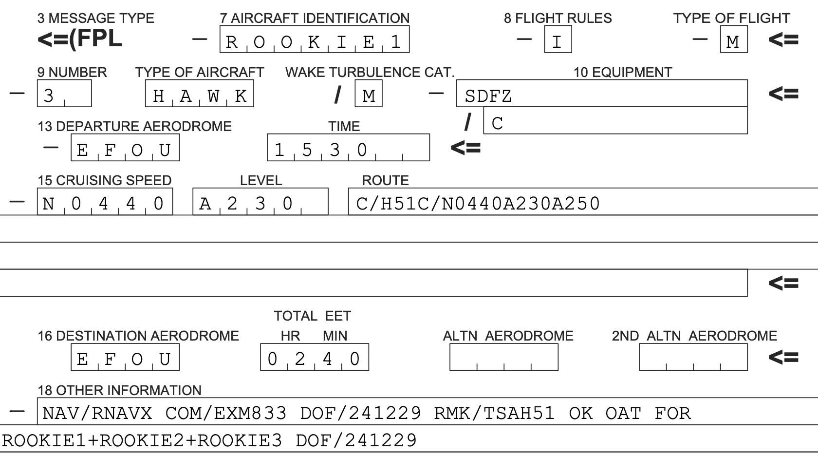](https://wiki.vatsim-scandinavia.org/uploads/images/gallery/2024-12/fpl-mil.png)
---
Phraseology
Military aircraft may start-up and taxi without taxi instructions on military aprons. Departing aircraft will receive the Runway Holding Point from ATC. Arriving aircraft will be instructed to "taxi to apron".
SSR codes are given to every aircraft in formation.
👨✈️
Oulu tower, MASTER 1, two-ship, taxiing to holding point M, departure in standard formation, information A, QNH 1013
Oulun torni, MASTER 1, kahdella, rullaan odotukseen M, lähtö tiiviissä osastossa, tiedotus A, QNH 1013
🎧
MASTER 1, Oulu tower, cross runway from M to B, taxi to holding point A runway 12, clearance available
MASTER 1, Oulun torni, ylitä kiitotie M kautta, rullaa odotukseen A kiitotie 12, selvitys saatavilla
👨✈️
Cross runway from M to B, taxiing to holding point A, ready to copy, MASTER 1
Ylitän kiitotien M kautta ja rullaan odotukseen A, valmiina kopioimaan, MASTER1
🎧
MASTER 1, cleared to point H51C, climb to block 11 thousand to 12 thousand feet, QNH 1013, squawk 3411
MASTER 1, selvä pisteelle H51C, nouse korkeusalueelle 11 tuhatta, 12 tuhatta jalkaa, QNH 1013, koodaa 3411
👨✈️
Cleared to point H51C, climb to block 11 thousand to 12 thousand feet, QNH 1013, squawk 3411, MASTER 1
Selvä pisteelle H51C, nousen korkeusalueelle 11 tuhatta, 12 tuhatta jalkaa, QNH 1013, koodaan 3411, MASTER 1
🎧
MASTER 2, squawk 3412
MASTER 2, koodaa 3412
👨✈️
Squawk 3412, MASTER 2
Koodaan 3412, MASTER 2
🎧
MASTER 1, clearance correct
MASTER 1, selvitys oikein