# Icelandic Airports & Charts
# Airport Briefings
Airport specified briefings for aerodromes within BIRD FIR
# BIKF – Keflavík International Airport
## Overview
Keflavík International Airport is Iceland’s primary international gateway and the main hub for long-haul and transatlantic operations across the North Atlantic. Located approximately 50 km southwest of Reykjavík, Keflavík serves as a strategic midpoint between Europe and North America and handles a high volume of oceanic, ETOPS, cargo, military, and international passenger traffic.
The airport is dominated by international operations, with Icelandair operating an extensive route network to Europe and North America. Cargo flights, NATO-related traffic, and business aviation are also common. Domestic traffic generally operates from Reykjavík Airport (BIRK), though some regional and positioning flights may use Keflavík.
Weather conditions at Keflavík can be highly dynamic throughout the year. Strong winds, low visibility, icing, turbulence, and rapidly changing cloud bases are common and require careful planning and aircraft handling.
### Available Stands
### Use of stands
| Area | Stands | Assigned to |
|---|
| Main Terminal Apron | 1-17 | International passenger operations |
| Terminal Remote East Apron | 71-78 | International passenger operations |
| Terminal Remote West Apron | 40-46 | International passenger operations |
| West Apron |
| Military Operations |
| East Apron |
| Private / Cargo Operations |
Widebody aircraft are commonly assigned to suitable terminal stands or remote stands depending on availability. Remote stand operations are frequent during peak traffic periods.
### IFR Clearance
Initial contact is with Clearance Delivery, reporting:
- Callsign
- Stand number
- ATIS identification letter
- Destination
Example: “Keflavík Delivery, ICE6MC stand 12, Airbus A320 with information Bravo, request IFR clearance to London Heathrow.”
Pilots unable to comply with published SIDs due to aircraft or navigation limitations should advise ATC immediately on first contact.
Oceanic clearances for westbound NAT operations are normally obtained prior to departure and pilots should ensure route uplinks and flight plans are verified before pushback.
### Push-back
Most terminal stands require pushback procedures due to apron layout constraints.
ATC may issue:
- Straight-back push
- Tail east/west push
- Face north/south push instructions
- TRP (Tug Release Point) instructions
Where a TRP (Tug Release Point) is assigned, aircraft should continue pushback or towing procedures until reaching the instructed release point before disconnecting the tug, unless otherwise instructed by ATC or ground handling personnel.
During high traffic periods, expect delayed push approvals due to limited taxiway availability and crossing traffic.
Pilots should remain on stand until pushback clearance has been received from Ground.
### Taxi
Taxi instructions normally include the full taxi route.
Pilots are expected to:
- Read back all hold short instructions
- Exercise caution during low visibility operations
- Monitor for de-icing traffic during winter operations
Intersection departures may be offered during busy periods if operationally suitable.
Heavy jet and long-haul aircraft generally taxi for full-length departures.
### Runways
Keflavík International Airport operates two primary runways:
| Runway | Length | Common Use |
|---|
| 10/28 | 10,056 ft | Primary arrival/departure runway |
| 01/19 | 10,020 ft | Secondary runway / crosswind operations |
Runway selection depends heavily on:
- Wind conditions
- Crosswind limitations
- Traffic flow
Low visibility procedures (LVP) are frequently used during winter months.
### SIDs
Standard Instrument Departures from Keflavík are heavily integrated into Icelandic and North Atlantic airspace structures.
Initial climb altitudes are assigned by ATC and must not be exceeded unless cleared.
Pilots should:
- Verify SID routing before taxi
- Ensure oceanic routes match filed flight plans
- Expect directs when traffic permits
If unable to comply with RNAV procedures, advise ATC for radar vectors or alternative departure instructions.
### Important Note When Departing
Keflavík IFR departures are frequently handed over shortly before departure.
Example: ICE6MC, When airborne \[contact XXX/monitor UNICOM\] on XXX.XX, winds XXX
degrees XX knots, runway XX, cleared for takeoff
### Arrival and STARs
Keflavík arrivals frequently involve:
- Oceanic inbound transitions
- RNAV STARs
- Radar vectoring during peak operations
Pilots should preload expected arrivals and transitions before descent.
Do not descend unless explicitly cleared by ATC. Receiving an arrival or STAR clearance does not automatically mean descent is approved.
Due to Icelandic terrain and rapidly changing weather, strict adherence to altitude restrictions is essential.
Direct routings are common when traffic conditions permit.
### Approach
Expect ILS approaches during normal operations.
Available approach types include:
| Runway | Approach Types | Frequency | Course |
| 10 | ILS/LOC, RNP, VOR, NDB | 109.50 | 102 |
| 28 | ILS/LOC, RNP, VOR | 108.50 | 282 |
| 01 | ILS/LOC, RNP, VOR | 111.30 | 012 |
| 19 | ILS/LOC, RNP, VOR | 110.30 | 192 |
### ILS Categories
Keflavík supports low visibility operations with multiple ILS-equipped runways. The available ILS categories are:
| Runway | ILS Category |
|---|
| 01 | CAT I |
| 28 | CAT I |
| 10 | CAT II |
| 19 | CAT II |
### Navigation Aids
Keflavík is equipped with several navigation aids used for arrivals, departures, oceanic transitions, and non-precision approaches.
| Navaid | Type | Frequency | Usage |
|---|
| KFV | VOR/DME | 112.80 | Primary navigation aid for arrivals, departures and approach procedures |
The KFV VOR/DME is located on the airfield and is widely used throughout published SIDs, STARs, approach procedures, and oceanic transition routing within Icelandic airspace.
Pilots should verify correct tuning and identification of the KFV VOR prior to conducting VOR-based procedures.
**KFV VOR/DME** Frequency: **112.80** Identifier: **KFV**
### Low Visibility Procedures (LVP)
LVPs are commonly used during winter operations due to fog, snow, strong winds, and rapidly changing weather conditions.
Pilots conducting CAT II approaches must ensure both aircraft and crew are certified and capable of CAT II operations prior to commencing the approach.
Visual approaches may be used during good weather conditions.
Strong crosswinds are common at Keflavík and pilots should be prepared for:
- Gusting winds
- Moderate turbulence
- Wind shear
- Rapid runway changes
Unless otherwise instructed, pilots should maintain approach speeds to ensure efficient sequencing.
### Direct Routings
In Icelandic airspace, direct routings are extremely common.
Pilots should be prepared for:
- Directs to oceanic entry points
- STAR shortcuts
- Vectoring around weather systems
Keep the waypoint page and flight plan readily available for quick modifications.
### Communications
You can always check online positions and sectors by visiting [VATSIM Radar](https://vatsim-radar.com)
| Callsign | Description | Frequency |
|---|
| BIKF\_ATIS | Keflavík ATIS | 128.300 |
| BIKF\_DEL | Keflavík Delivery | 121.000 |
| BIKF\_GND | Keflavík Ground | 121.900 |
| BIKF\_TWR | Keflavík Tower | 118.300 |
| BIKF\_APP | Keflavík Approach | 119.300 |
| BIRD\_S1\_CTR | Reykjavík Control | 119.700
|
Additional frequencies and sector splits may be used during major events or periods of high traffic.
### Notes
- Keflavík is a major North Atlantic ETOPS diversion airport.
- De-icing operations are frequent during winter months.
- Volcanic ash advisories may impact operations across Icelandic airspace.
- Strong winds and rapidly changing meteorological conditions are common year-round.
- Pilots should ensure adequate fuel planning for weather diversions and oceanic contingency procedures.
# BIRK - Reykjavík Airport
## Overview
Reykjavík Airport (BIRK) is Iceland’s primary domestic airport and serves as a major hub for regional operations across Iceland, Greenland, and the North Atlantic region. Located close to central Reykjavík, BIRK handles domestic scheduled services, air ambulance flights, Coast Guard operations, general aviation, business aviation, helicopter traffic, and occasional international regional flights.
The airport is operated in a highly dynamic environment with a mixture of turboprop, helicopter, training, and business aviation traffic. Due to its proximity to Reykjavík city and surrounding terrain/water, pilots should expect visual manoeuvring, rapidly changing weather conditions, and short-notice runway changes.
Weather conditions at Reykjavík can change rapidly throughout the day. Strong winds, low cloud, turbulence, snow showers, icing, and reduced visibility are common, particularly during winter operations.
### Use of Aprons
| Area | Assigned to |
|---|
| Apron 1 | General Aviation |
| Apron 2 | Coast Guard |
| Apron 3 | General Aviation |
| Apron 4 | Domestic / Scheduled Passenger |
| Apron 7 | Icelandic Flight Academy |
### IFR Clearance
Initial contact is with Clearance Delivery, reporting:
- Callsign
- Stand number
- ATIS identification letter
- Destination
Example: “Reykjavík Delivery, ICE1DC stand 4, Dash 8 with information Charlie, request IFR clearance to Akureyri.”
Pilots unable to comply with published SIDs due to aircraft or navigation limitations should advise ATC immediately on first contact.
### Push-back
Some terminal stands require pushback procedures due to apron layout constraints, although many domestic stands allow power-out departures.
ATC may issue:
- Straight-back push
- Tail east/west push
- Face north/south push instructions
Pilots should remain on stand until pushback clearance has been received from Ground.
### Taxi
Taxi instructions normally include the full taxi route.
Pilots are expected to:
- Read back all hold short instructions
- Exercise caution during low visibility operations
- Monitor for helicopter and GA traffic
### Runways
Reykjavík Airport operates three intersecting runways:
| Runway | Length | Common Use |
|---|
| 01/19 | 5,156 ft | Primary domestic operations |
| 13/31 | 4,734 ft | Regional & crosswind operations |
Runway selection depends heavily on:
- Wind conditions
- Traffic flow
- Crosswind limitations
- Weather conditions
### SIDs
Standard Instrument Departures from Reykjavík integrate into Icelandic domestic and regional airspace structures.
Initial climb altitudes are assigned by ATC and must not be exceeded unless cleared.
If unable to comply with RNAV procedures, advise ATC for radar vectors or alternative departure instructions.
### Arrival and STARs
Reykjavík arrivals frequently involve:
- RNAV arrivals
- Visual approaches
- Radar vectoring
- Short-notice runway changes
Do not descend unless explicitly cleared by ATC.
### Approach
Expect visual or RNAV approaches during normal operations depending on runway configuration and weather conditions.
| Runway | Approach Types | Frequency | Course |
| 01 | RNP |
| 007 |
| 19 | ILS, LOC, RNP | 109.90 | 187 |
| 13 | LOC, RNP, NDB | 109.10 | 128 |
| 31 | RNP |
| 308 |
Strong crosswinds are common at Reykjavík and pilots should be prepared for:
- Gusting winds
- Moderate turbulence
- Wind shear
- Rapid runway changes
### Navigation Aids
Reykjavík is equipped with navigation aids supporting domestic, regional, and instrument operations.
| Navaid | Type | Frequency | Usage |
|---|
| RK | NDB | 355 | Primary navigation aid for arrivals and departures |
**RK NDB**
Frequency: **355**
Identifier: **RK**
### Low Visibility Procedures (LVP)
LVPs may be implemented during periods of reduced visibility, snowfall, or fog.
### Direct Routings
Direct routings are common within Icelandic domestic airspace.
Pilots should be prepared for:
- Directs to enroute fixes
- Shortened arrivals
- Vectoring around weather systems
### Communications
You can always check online positions and sectors by visiting [VATSIM Radar](https://vatsim-radar.com)
| Callsign | Description | Frequency |
|---|
| BIRK\_ATIS | Reykjavík ATIS | 128.100 |
| BIRK\_GND | Reykjavík Ground | 121.700 |
| BIRK\_TWR | Reykjavík Tower | 118.000 |
| BIRK\_APP | Reykjavík Approach | 119.300 |
| BIRD\_S1\_CTR | Reykjavík Control | 119.700
|
Additional frequencies and sector splits may be used during major events or periods of high traffic.
### Notes
- Reykjavík is Iceland’s primary domestic airport.
- Helicopter traffic is frequent throughout the day.
- Rapid weather changes are common year-round.
- Visual manoeuvring is frequently required.
- Crosswind operations are common due to Icelandic weather patterns.
# BIAR - Akureyri Airport
## Overview
Akureyri Airport (BIAR) is the main airport serving Akureyri and northern Iceland. The airport supports domestic scheduled flights, regional services, general aviation, air ambulance operations, training flights, and occasional international or charter traffic.
Akureyri is an important regional airport in Iceland, with traffic often operating to and from Reykjavík, Greenland, and smaller Icelandic communities. Due to its northern location and surrounding terrain, pilots should expect challenging weather, turbulence, icing conditions, and close attention to published procedures.
Weather conditions at Akureyri can change rapidly. Low cloud, snow showers, strong winds, reduced visibility, and winter contamination are common, particularly during the colder months.
### Use of stands
| Area | Stands | Assigned to |
|---|
| Main Apron - North & South | 1-6 | Domestic passenger operations |
| Remote / GA Apron | 7-12 | General aviation, business aviation & overflow parking |
| Helicopter / Special Operations | As assigned | Helicopter, ambulance and special operations |
Regional turboprop aircraft commonly operate from the main apron, while general aviation, business aviation, and special operations may be positioned on remote or dedicated apron areas depending on traffic levels.
### IFR Clearance
Initial contact is with Akureyri Tower, reporting:
- Callsign
- Stand number or parking position
- ATIS identification letter
- Destination
Example: “Akureyri Tower, ICE4AH stand 2, Dash 8 with information Alpha, request IFR clearance to Reykjavík.”
Pilots unable to comply with published SIDs due to aircraft or navigation limitations should advise ATC immediately on first contact.
### Push-back
Most stands at Akureyri are suitable for power-out or self-manoeuvring operations, depending on aircraft type and traffic situation.
ATC may issue:
- Power-out approved
- Straight-back push
- Tail east/west push
- Face north/south push instructions
Pilots should remain on stand until pushback, taxi or power-out clearance has been received from ATC.
### Taxi
Taxi instructions normally include the full taxi route. Pilots should use caution due to the compact apron layout and mixed traffic environment.
- Read back all hold short instructions
- Monitor for GA, ambulance and regional traffic
- Exercise caution in winter conditions
### Runways
Akureyri Airport operates a single runway:
| Runway | Length | Common Use |
|---|
| 01/19 | 2,400 m / 7,874 ft | Primary arrival and departure runway |
Runway selection depends heavily on:
- Wind conditions
- Visibility
- Traffic flow
- Runway condition
- Aircraft performance
### SIDs
Standard Instrument Departures from Akureyri integrate into Icelandic domestic and regional airspace.
Initial climb altitudes are assigned by ATC and must not be exceeded unless cleared.
Pilots should:
- Verify SID routing before taxi
- Ensure the filed route matches the expected departure routing
- Expect directs when traffic permits
If unable to comply with RNAV procedures, advise ATC for radar vectors or alternative departure instructions.
### Important Note When Departing
Akureyri IFR departures may be handed over shortly before or after departure depending on ATC coverage.
Example: “ICE4AH, when airborne contact Reykjavík Control on XXX.XXX, wind XXX degrees XX knots, runway XX, cleared for takeoff.”
### Arrival and STARs
Akureyri arrivals may involve:
- RNAV arrivals
- VOR/NDB-based procedures
- Radar vectoring when available
- Visual approaches when conditions permit
Pilots should preload expected arrivals and approaches before descent where possible.
Do not descend unless explicitly cleared by ATC. Receiving an arrival or approach clearance does not automatically mean unrestricted descent unless the procedure and clearance allow it.
### Approach
Expect an instrument approach during poor weather, with visual approaches available when conditions permit.
| Runway | Approach Types | Frequency | Course |
| 01 | ILS/LOC, RNP | 108.90 | 008 |
| 19 | RNP, VOR, NDB | 110.50 | 183 |
### ILS Categories
Akureyri has an ILS/LOC approach available for runway 01.
| Runway | ILS Category |
|---|
| 01 | CAT I |
### Navigation Aids
Akureyri is supported by navigation aids used for arrivals, departures and instrument approach procedures.
| Navaid | Type | Frequency | Usage |
|---|
| AKI | VOR/DME | 113.60 | Primary navigation aid for Akureyri procedures |
The AKI VOR/DME is used for published arrivals, departures and non-precision approach procedures serving Akureyri.
Pilots should verify correct tuning and identification of the AKI VOR prior to conducting VOR-based procedures.
**AKI VOR/DME** Frequency: **113.60** Identifier: **AKI**
### Low Visibility Procedures (LVP)
Reduced visibility operations may occur during fog, snow, blowing snow, or low cloud. Pilots should ensure they are familiar with the published approach minima and runway condition reports.
Pilots conducting low visibility or winter operations should confirm runway condition, braking action, approach minima and aircraft capability before commencing the approach.
Visual approaches may be used during good weather conditions.
Strong crosswinds and challenging weather are common at Akureyri and pilots should be prepared for:
- Gusting winds
- Moderate turbulence
- Wind shear
- Rapid runway changes
- Winter contamination
### Direct Routings
Direct routings are common within Icelandic domestic airspace when traffic and ATC workload permit.
- Directs to enroute fixes
- Shortened arrivals
- Vectoring around weather systems
Keep the waypoint page and flight plan readily available for quick modifications.
### Communications
You can always check online positions and sectors by visiting [VATSIM Radar](https://vatsim-radar.com).
| Callsign | Description | Frequency |
|---|
| BIAR\_ATIS | Akureyri ATIS | 136.200 |
| BIAR\_TWR | Akureyri Tower | 118.200 |
| BIRD\_S1\_CTR | Reykjavík Control | 119.700 |
Additional frequencies and sector splits may be used during major events or periods of high traffic.
### Notes
- Akureyri is a key airport for northern Iceland domestic operations.
- Terrain and weather can make approaches challenging.
- Winter runway conditions should be carefully checked before departure and arrival.
- Regional turboprop and ambulance traffic are common.
- Pilots should be prepared for visual manoeuvring when weather permits.
# EKVG - Vágar Airport
## Overview
Vágar Airport (EKVG) is the main airport serving the Faroe Islands. Located on the island of Vágar, the airport supports scheduled passenger flights, regional services, business aviation, helicopter operations, search and rescue activity, and occasional charter traffic.
Vágar is a challenging North Atlantic airport due to surrounding terrain, rapidly changing weather, sea winds, turbulence, and low cloud. Pilots should expect close attention to published procedures, approach minima, and runway conditions.
Weather conditions at Vágar can change quickly. Strong winds, low visibility, rain, fog, turbulence, wind shear, and rapidly lowering cloud bases are common throughout the year.
### Available Stands
### Use of stands
| Area | Stands | Assigned to |
|---|
| Main Apron | 1-5 | Passenger operations |
| GA / Remote Apron | As assigned | General aviation, business aviation & overflow parking |
| Helicopter Area | As assigned | Helicopter, SAR and special operations |
### IFR Clearance
Vágar is normally operated as an AFIS / information service environment. Initial contact is with Vágar Information, reporting:
- Callsign
- Stand number or parking position
- ATIS / information received, if available
- Destination
- Requested clearance or intentions
Example: “Vágar Information, FLI55AW stand 2, Airbus A320 with information Alpha, request IFR clearance to Copenhagen.”
**Information Service:** Vágar operates as an AFIS / Information service. Pilots remain responsible for terrain clearance, runway separation, and sequencing unless otherwise coordinated. Expect advisory information rather than full ATC separation services.
### Push-back
Most stands at Vágar may require pushback or careful manoeuvring due to the compact apron layout.
Vágar Information may issue:
- Straight-back push
- Face east/west push instructions
- Power-out approved where suitable
### Taxi
Taxi instructions normally include the full taxi route. Pilots should use caution due to the compact apron, terrain, and possible strong wind conditions.
- Read back all hold short instructions
- Monitor for helicopter and regional traffic
- Exercise caution during strong wind or low visibility conditions
- Expect backtracking depending on traffic and runway in use
### Runways
Vágar Airport operates a single runway:
| Runway | Length | Common Use |
|---|
| 12/30 | 1,799 m / 5,902 ft | Primary arrival and departure runway |
Runway selection depends heavily on wind, visibility, traffic flow, runway condition and aircraft performance.
### SIDs
Standard Instrument Departures from Vágar route aircraft safely away from surrounding terrain and into North Atlantic regional airspace.
Initial climb altitudes are assigned by ATC and must not be exceeded unless cleared.
If unable to comply with RNAV procedures, advise ATC for alternative departure instructions.
### Important Note When Departing
Vágar departures are frequently handed over shortly after departure depending on ATC coverage and traffic levels.
**AFIS Operations:** Vágar operates as an Information / AFIS service rather than a fully controlled aerodrome. Pilots are responsible for ensuring runway separation and determining whether it is safe to depart based on the information provided.
Example: “FLI55AW, runway 30 is free, surface wind 310 degrees 18 knots, when airborne contact Reykjavík Control on XXX.XXX.”
Under AFIS procedures, Vágar Information will provide runway, traffic, weather and operational information, however formal takeoff clearances are not issued. Pilots should acknowledge the information and commence departure when safe to do so.
### Arrival and STARs
Vágar arrivals may involve:
- RNAV arrivals
- Radar vectoring when available
- Visual approaches when conditions permit
- Short-notice runway changes due to wind
Do not descend unless explicitly cleared by ATC. Receiving an arrival or approach clearance does not automatically mean unrestricted descent unless the procedure and clearance allow it.
### Approach
Expect an instrument approach during poor weather, with visual approaches available when conditions permit.
| Runway | Approach Types | Frequency | Course |
| 12 | LOC, RNP | 109.10 | 109 |
| 30 | ILS, RNP | 110.30 | 302 |
### ILS Categories
| Runway | ILS Category |
|---|
| 30 | CAT I |
### Navigation Aids
Vágar is supported by navigation aids used for arrivals, departures and instrument approach procedures.
| Navaid | Type | Frequency | Usage |
|---|
| VG | NDB | 348 | Non-precision approach and missed approach reference |
| MY | NDB | 337 | Non-precision approach and missed approach reference |
### Low Visibility Procedures (LVP)
Reduced visibility operations may occur during fog, rain, low cloud or poor weather. Pilots should ensure they are familiar with the published approach minima and runway condition reports.
Pilots conducting instrument approaches into Vágar should closely monitor terrain clearance and weather conditions due to the surrounding mountainous terrain and rapidly changing visibility.
### Direct Routings
Direct routings may be issued when traffic and workload permit.
- Directs to enroute fixes
- Shortened arrivals
- Vectoring around weather systems
### Communications
You can always check online positions and sectors by visiting [VATSIM Radar](https://vatsim-radar.com).
| Callsign | Description | Frequency |
|---|
| EKVG\_I\_TWR | Vágar Information / AFIS | 124.850 |
| BIRD\_S1\_CTR | Reykjavík Control | 119.700 |
When Vágar Information is online, pilots should treat the service as AFIS rather than full tower control. Expect traffic information, runway information, weather information and advisory instructions rather than full radar or tower control separation.
### Notes
- Vágar is the main airport serving the Faroe Islands.
- Terrain, sea winds and rapidly changing weather make operations challenging.
- Low cloud, turbulence and wind shear are common.
- Helicopter and special operations traffic may be active.
- Pilots should review published procedures carefully before arrival or departure.
# A Quick Guide to Mach Numbers
One of the most common questions that VATSIM pilots ask when they fly in the BIRD CTA/OCA for the first time are 1. What is a Mach number, and 2. How/where do I find it?
This guide attempts to briefly address both questions, to the extent necessary for VATSIM purposes.
## What is a Mach number?
A **Mach** **number,** or Mach speed, is your speed relative to the speed of sound (Mach 1 = the speed of sound itself.) For example, Mach 0.80 = 0.8 times, or 80%, of the speed of sound.
At cruise, and especially in oceanic airspace, ATC uses your speed in Mach to separate aircraft from each other by speed control. Therefore, when requesting oceanic clearance, it is generally required to provide your requested Mach number/Mach speed for the oceanic crossing.
For light aircraft flying too slow to changeover into Mach speed (<Mach 0.50), just let ATC know. ATC will issue you an oceanic clearance without a Mach number.
## How do I find my Mach number?
There are several ways to check what your Mach number is. Generally, assuming you have generated your flight plan using Simbrief or a similar tool, the easiest is to check your **flight plan route**.
Whenever you enter oceanic airspace, your ATC flight plan's Route section (item 15 on an ICAO flight plan) should note your planned Mach number next to the **first oceanic waypoint of your route — OR at the start of your flight plan route**, if you are departing from an airport underlying oceanic airspace already (like those in Iceland, Greenland, and the Faroe Islands.)
This generally follows the format `MxxxFxxx`, where the three digits after M are the Mach number (a decimal point goes after the 1st digit), and the three digits after F are the planned flight level at that waypoint.
- E.g., `M078F350` means Mach 0.78 at FL350.
#### **Example 1:** Departing an airport underlying the BIRD CTA
[](https://wiki.vatsim-scandinavia.org/uploads/images/gallery/2023-11/ATBimage.png)
[](https://wiki.vatsim-scandinavia.org/uploads/images/gallery/2023-11/BCnimage.png)
*(The 1st screenshot is from Simbrief's Flight Briefing webpage; the 2nd is from the OFP/Operational Flight Plan PDF.)*
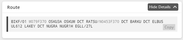
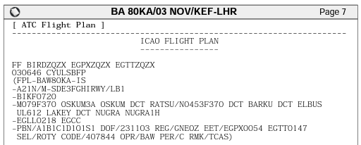
In this example, the aircraft is departing from Keflavik int'l airport (BIKF) in Iceland. Therefore, the oceanic portion of your flight starts from essentially the very beginning of your route, and so your planned Mach number (and planned cruising level) is listed at the start of the flight plan route. In this case, it is **Mach 0.79** at **FL370.**
#### **Example 2:** Passing through BIRD CTA enroute
[](https://wiki.vatsim-scandinavia.org/uploads/images/gallery/2023-11/uG0image.png)
[](https://wiki.vatsim-scandinavia.org/uploads/images/gallery/2023-11/ddWimage.png)
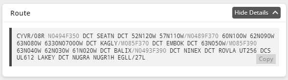
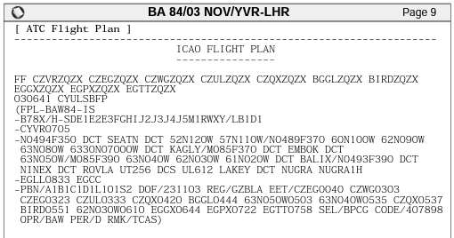
In this example, because the aircraft enters oceanic airspace starting at **KAGLY**, the oceanic Mach number & requested flight level are listed after that waypoint with a slash — `KAGLY/M085F370`, which means at KAGLY you are planning **Mach 0.85** at **FL370.**
There are also other ways to check your Mach number — for example, looking at your flight log (which should list your vertical and speed profile), or simply looking at your primary flight display/airspeed indicator if you are already airborne. The above is *one* simple way to check your planned Mach speed, but relying on this number is not a substitute for good planning and due diligence as a pilot.
Pilots are *strongly encouraged* to cross-check your Mach speed using multiple methods, to ensure you are reporting an accurate Mach speed to ATC.
# General Briefing
## Introduction
[](https://wiki.vatsim-scandinavia.org/uploads/images/gallery/2023-11/9rHimage.png)
*Illustration by Isavia.*
The **Reykjavik Control Area (BIRD CTA)** covers over 5.4 million square kilometres of oceanic airspace between North America and Europe, stretching all the way to the North Pole. Under this airspace lie three territories: Iceland, Greenland and the Faroe Islands, each with unique geography, airports, and airspace. Together, they offer the VATSIM pilot limitless opportunities for flying.
Our closest neighbors are **Norway, Canada,** and **Scotland.** Neighboring FIRs and oceanic areas include Murmansk (ULMM), Bodo Oceanic (ENOB), Polaris (ENOR/ENSV), Scottish (EGPX/SCO), Shanwick (EGGX), Gander (domestic & oceanic; CZQX/CZQO), and Edmonton (CZEG.)
## Sectors
The BIRD CTA is split into four sectors: **North, South, East,** and **West.**
[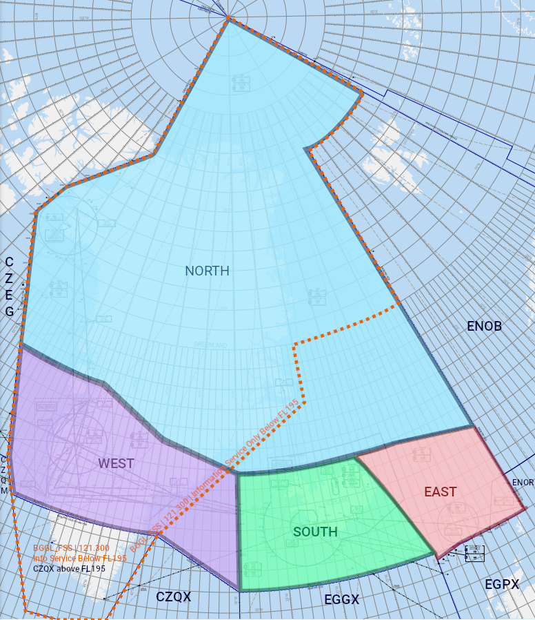](https://wiki.vatsim-scandinavia.org/uploads/images/gallery/2023-11/sector-diagram-clean.png)
The most commonly staffed Reykjavik Control position is **BIRD\_S1\_CTR** (frequency 119.700.) This position, when online by itself, covers the **West, South, and East** sectors, and provides top-down coverage for **all of Iceland (BI\*\* airports)**, **EKVG** (& surrounding airspace of the Faroe Islands), and **BGSF** (& surrounding airspace over parts of central Greenland.)
There are, of course, various other BIRD positions available to be opened, where multiple controllers split the various BIRD sectors between them. When multiple BIRD positions are open, you may check [vatglasses.uk](https://vatglasses.uk/) to see which controller is controlling what airspace, or wait for a “contact me” message from the controller.
**NOTE:** Sometimes, during major events like Cross the Pond, the division of airspace between controllers may be changed from what it usually is, to accommodate the specific needs of that event. **This may cause Vatglasses to be inaccurate.** If you receive a “contact me” message from a BIRD controller, even if Vatglasses says you’re not in their airspace, **do what the controller says.**
The North sector is controlled exclusively by **Iceland Radio (BICC\_x\_FSS.)** Iceland Radio is a unique position on VATSIM that provides a variety of air traffic services, including:
- ATC in the North sector.
- IFR clearances for departures on the ground at Greenlandic uncontrolled airports (usually relayed by local AFIS, but if no local AFIS is online, then pilots may contact BICC directly.)
- *(If BGGL\_FSS/Nuuk Information is offline and workload permits)* Flight information service in Nuuk FIR below FL195, including top-down ATC at BGSF (Kangerlussuaq) if no local BGSF ATC is online.
If you are confused about when to talk to Iceland Radio, simply message the controller (we’re always happy to help, provided we’re not too busy!) or wait for a “contact me” message.
## Oceanic Airspace
Much of the BIRD CTA — except some low-level airspace over Iceland and Greenland — is **oceanic airspace,** forming of the North Altantic (NAT) oceanic area. The parts of the BIRD CTA which are oceanic airspace are known as the **Reykjavik Oceanic Area (BIRD OCA.)**
Even though the BIRD OCA is oceanic airspace, the *entirety* of the BIRD CTA/OCA has either radar or ADS-B coverage within controlled airspace. Therefore, **position reports are not required,** and pilots can expect to receive a typical ATS surveillance service similar to any domestic ATC position, including speed control, vectors, etc.
### NAT Tracks
The North Atlantic oceanic airspace uses a system of tracks called the **North Atlantic Organized Track System (NAT OTS,)** to regulate traffic crossing the ocean. While usually remaining in Shanwick & Gander OCAs, the tracks do occasionally enter the Reykjavik OCA.
If you want to learn more about how the NAT tracks work, read [this helpful guide](https://knowledgebase.ganderoceanic.ca/1.0/basics/nats/#the-nat-track-message) published by the Gander OCA on VATSIM. (Ignore the sections on the routes & Concorde tracks, as they are not relevant to the BIRD OCA.)
### Entering Oceanic Airspace
As of 19th March 2026 aircraft entering the Reykjavik ACC no longer require an RCL as per Nat Doc 007 Chapter 6 section 6.3.24
**All flights entering oceanic airspace must have an IFR clearance.** It is not permitted to fly VFR in oceanic airspace – you must either fly below controlled airspace (generally, below FL55 over the ocean, or below FL195 over Greenland), or obtain IFR clearance.
**If you are:**
- Already airborne,
- Entering BIRD OCA, and
- Have not previously spoken to any other oceanic ATC (Gander, Shanwick, etc.)
### Voice Phraseology
This is an example of communication between a pilot and the controller when entering the Reykjavik ACC
> 🧑✈️ Reykjavik Control, ICE123, FL380
>
> 🎧 ICE123, Reykjavik Control, Identifed
>
> The controller then may ask you for your Mach number (This is pottentionally for forward planning and flow management)
>
> 🎧 ICE123, Say Mach number
>
> 🧑✈️ ICE123, Mach decimal 78
>
> 🎧 ICE123, roger, Maintain Mach decimal 78.
>
> The controller may ask you to increase or decrease your Mach speed depending on traffic in the area or for flow management.
## Within Oceanic Airspace
### Cost Index (ECON) Operations
In oceanic airspace, you may now fly in Cost Index (ECON) mode for optimal fuel efficiency – you do not have to strictly adhere to a specific Mach number.
Note that controllers may still instruct you to fly a fixed Mach number if required for separation.
This procedure was previously known as "Operation Without Assigned Fixed Speed" (OWAFS) – the difference is that now (as of 20th March 2024), pilots are expected to fly ECON mode *by default.*
### Strategic Lateral Offset Procedures (SLOP)
In BIRD OCA, **above FL285,** you may use [SLOP (Strategic Lateral Offset Procedures)](https://knowledgebase.ganderoceanic.ca/1.0/basics/slop/). This is a random offset off your aircraft's track, intended to "artificially" induce a navigation error that reduces the likelihood two aircraft will occupy the same airspace at once.
At pilot's discretion, aircraft with the capability to offset (using their FMS) may offset **right** of track, up to a maximum of **2 NM** (the exact offset you choose should be random.) ATC does not need to approve SLOP, or be informed when SLOP is in use. **Left offsets are prohibited.**
You must not apply SLOP below FL285 in the Reykjavik OCA, and must end the use of SLOP before entering domestic airspace.