Norwegian Airports & Charts
- Airport Briefings
- ENGM – Oslo Lufthavn
- ENBR – Bergen Flesland
- ENVA – Trondheim Værnes
- ENZV - Stavanger/Sola
- ENTC – Tromsø Langnes
- ENTO - Torp Sandefjord
- ENCN - Kristiansand Kjevik
- General recommendations
- Airport Sceneries
- Norway Offshore Guide
Airport Briefings
Airport specified briefings for aerodromes within ENOR/ENOB FIR
ENGM – Oslo Lufthavn
Overview
Oslo Airport, Gardermoen is the main airport of the Norwegian capital Oslo, and the main international airport of Norway. Having earlier served as a secondary airport, air force base, and charter airport, Gardermoen opened as the new main airport of Oslo on October the 8th 1998, replacing the now closed Fornebu Airport. Today, it has over 22 million passengers passing through each year, with 162 destinations worldwide, from short domestic flights to intercontinental long hauls.
Available stands
Stands
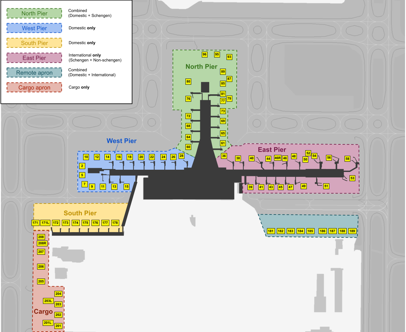
| Pier/Apron | Stands | Assigned to |
|---|---|---|
| West Pier | 2-28 | Domestic Only |
| East Pier | 36-44 | Schengen only |
| 40-53 | Non-schengen only | |
| North Pier | 60-96 | Domestic & Schengen Only |
| South Pier | 171-178 | Domestic mainly |
| Remote apron | 181-189 | International mainly |
| Cargo Apron | 201-208 | Cargo only |
| GA Apron | 313-332 | General aviaton |
IFR clearance
Initial contact is with Clearance Delivery, reporting callsign, stand number, and latest ATIS identification letter and QNH.
Requesting De-Icing
If you require de-ice prior to your departure, request with your departure clearance request.
DCL: Include clearence request with Remark REQ DEICE
Voice: Upon inital contact with GARDEMOEN DELIVERY, advise if de-ice is required.
Pushback
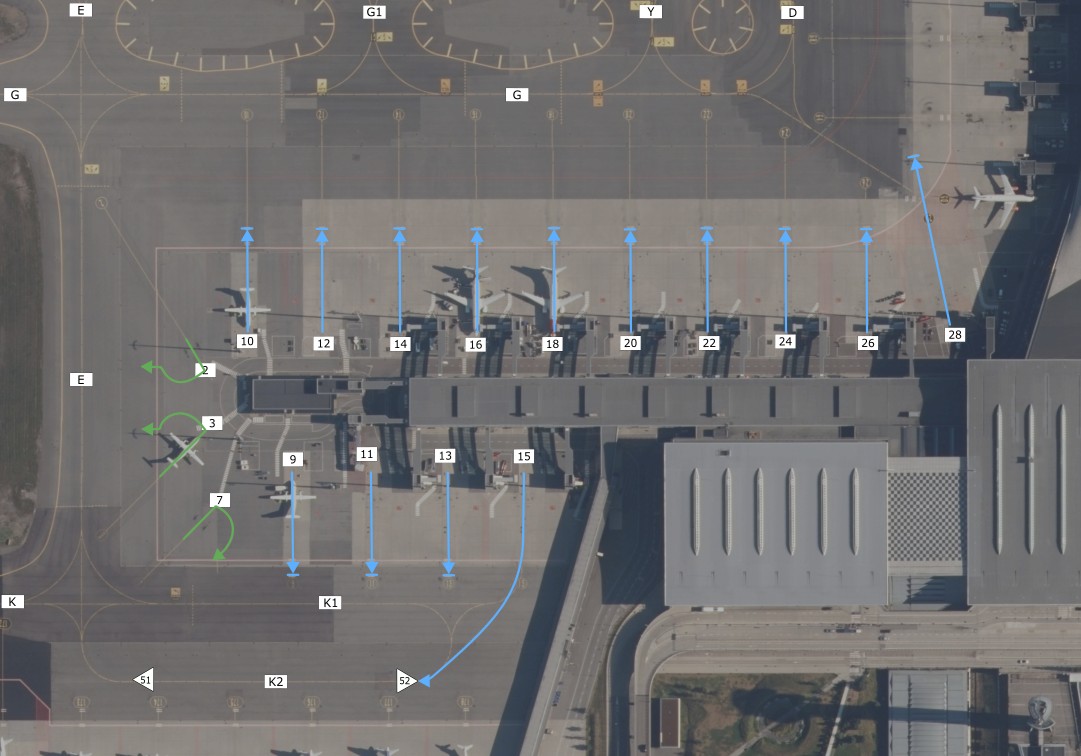
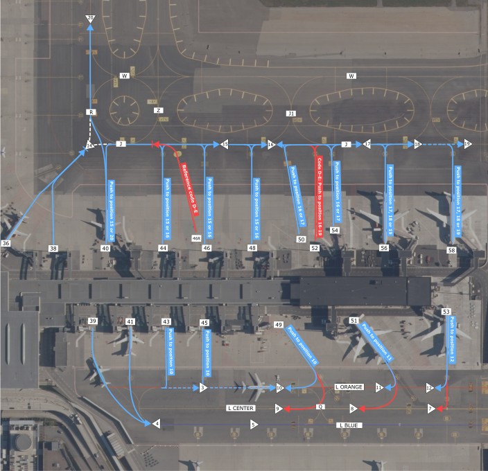
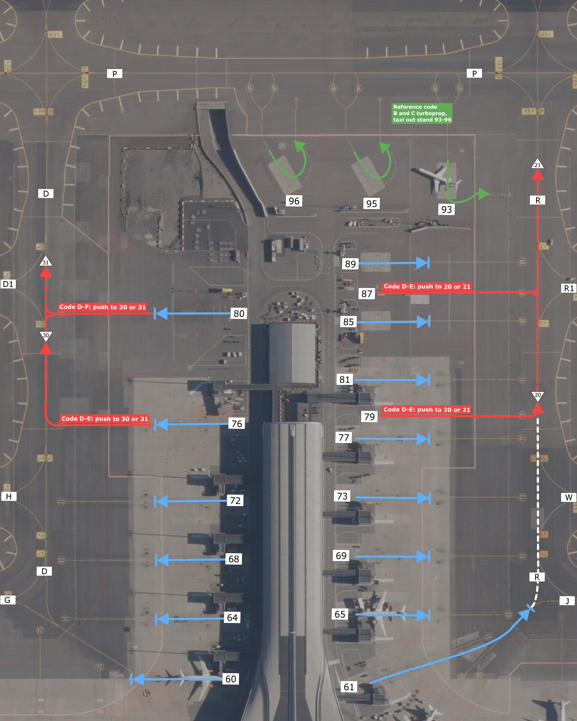
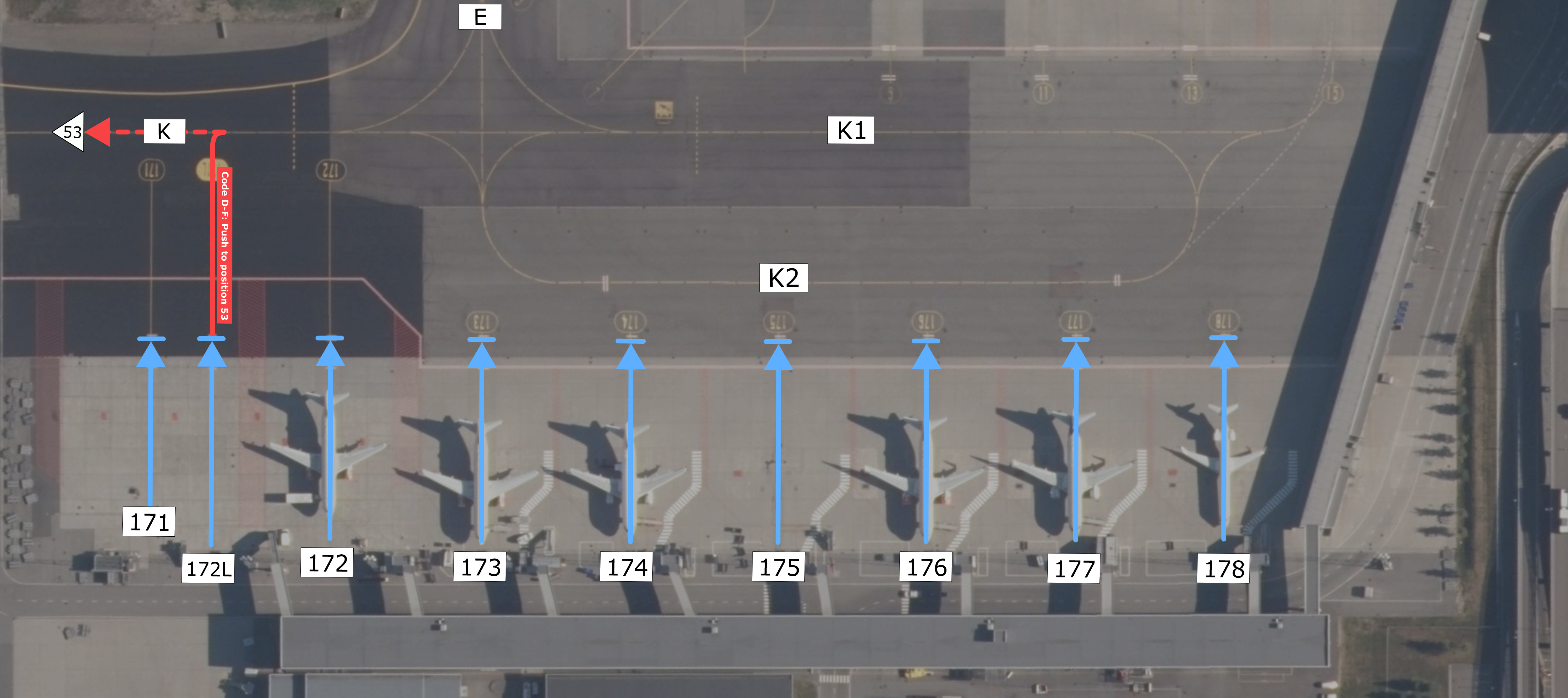
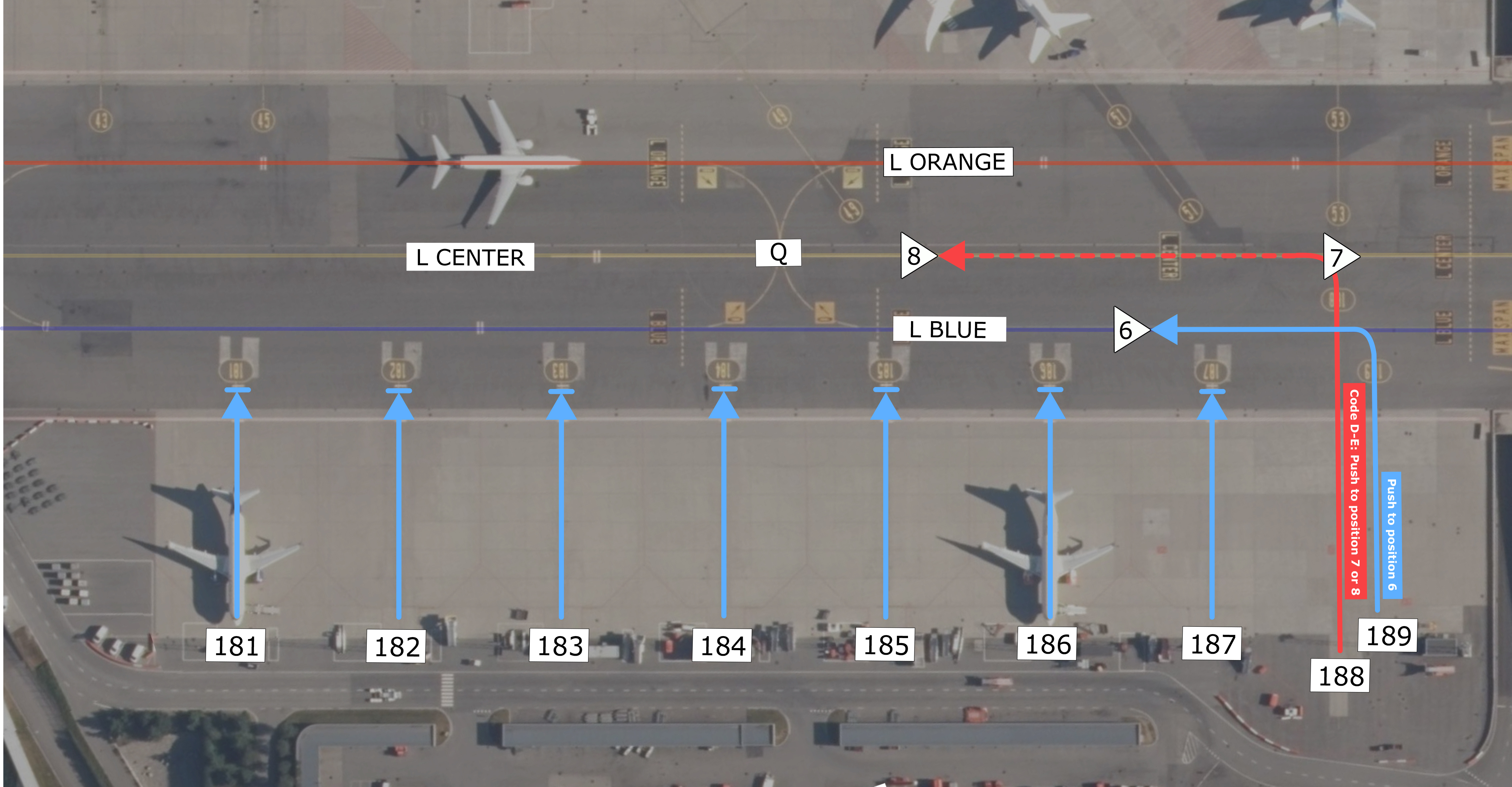
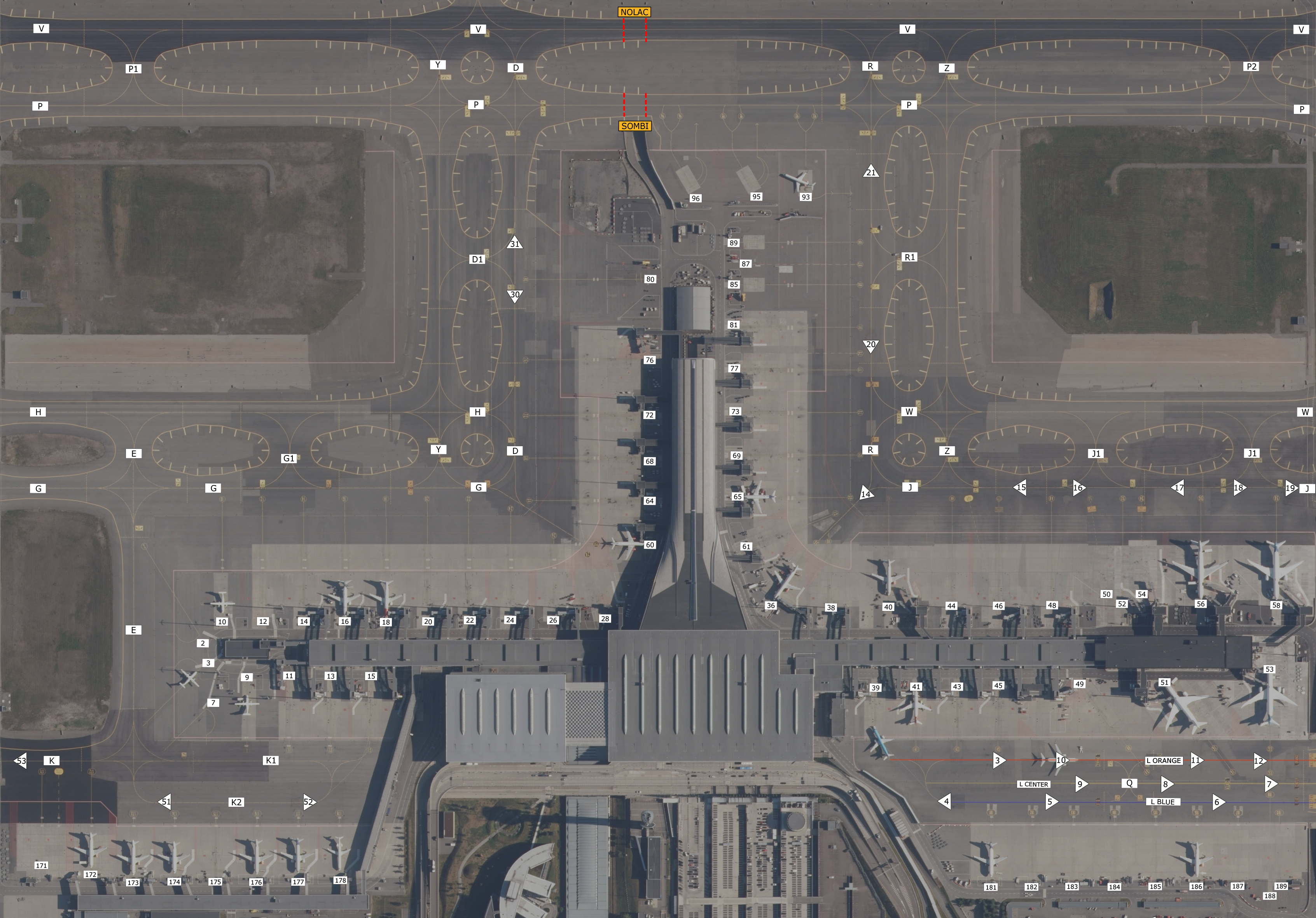
Most of the terminal gates requires straight-back pushes, however a few have turn-pushes. Please have a look on the maps below to see how you should perform your push from the stand. You can click on the images to have a closer look.
Pushback maps
Stand 1-28 | Pier West
Stand 36-58 | Pier East
Stand 60-96 | Pier North
Stand 171-178
Stand 181-189
Overview
Taxi
Taxi instructions at Gardermoen includes the full taxi route, however the runway intersection is not always included. If for example “holding point runway xx” is stated in your instruction, you are encouraged to call ATC with “C/S, ready via intersection xx ” as you approach this intersection, and it may be approved if traffic permits. Make sure to double-check if you are able to use the runway length from the intersection before requesting it.
Holding point assignmemt
On runway 01R, always expect to use full length via B1 or B2, due to noise abatement procedures.
If an intersection has not been specified, you may taxi to full-length, or advice ATC if able to depart from any earlier intersection.
Runways
Given that you’ve parked according to the paragraph describing the Use of stands, usually the eastern runway (19L/01R) is used for international departures/arrivals, and the western (19R/01L) for domestic departures/arrivals. This however is not a set rule, and runways are organized to accommodate high traffic loads.
The western runway (19R/01L) has a TORA of 3600m, the eastern runway (19L/01R) has a TORA of 2950m.
During winter operations the airport normally operates with a segregated runway configuration, landing on 01R/19R and departing 01L/19L, due to location of the active de-icing pads.
SIDs
All SIDs are individually numbered for each runway. When receiving your clearance, know that the SID stated is only valid for one runway, in case the controller forgets to state the departure runway.
STARs
Oslo Airport Gardermoen was one of the first airports in Europe to implement a “Point Merge System”, or PMS. This means that all STARs end up in a “fan” made out of waypoints equidistant from a central merge waypoint. Pilots should always be prepared for a direct routing towards the merge waypoint, 4 in total, in order to ease the workload of approach ATC.
All STARs are valid for both parallel runways, 19L/R or 01L/R. Approach (or Director when online) is to inform you of which runway to expect for landing.
The last fix of the STAR (or Merge Point) is followed by a transition to the ILS approach for each runway. ATC often replace these with vectoring, but always be prepared to fly the transition, and do NOT fly direct from the merge point to the Final Approach Fix. If you have no transitions available, inform ATC and request vectoring.
Study the approach charts, and make sure to always follow altitude and speed restriction, unless otherwise instructed by ATC.
Approach
The default approach to Gardermoen is ILS for all runways. All runways are CAT III equipped. In case of low visibility conditions, only the "right" runway is used for landing (01R or 19R). Curved RNP (AR) approaches are encouraged and may be available on request if traffic permits. (Remember to add T1 to your FPL under PBN/ in Item 18).
Fly at minimum 160 KT IAS to DME 4 GP on ILS approach and 4 NM final for RNP approach unless a different speed is instructed by ATC. Advise if unable to follow these restrictions.
Visual approach is not permitted for jet aircraft.
Direct routings
In Norway, direct routings are often used. Both arriving and departing traffic should be prepared to fly direct to the end of SIDs, STAR Merge Points, and airspace border fixes. Make sure you have your filed route and waypoint page available to quickly accommodate direct routings.
Communications
You can always check online positions and sectors by visiting vatglasses.uk
| Main logon | Frequency | Position |
|---|---|---|
| ENGM_A_ATIS | 126.130 | Gardermoen Arrival ATIS |
| ENGM_D_ATIS | 127.155 | Gardermoen Departure ATIS |
| ENGM_W_DEL | 121.680 | Gardermoen Delivery West |
| ENGM_E_DEL | 121.930 | Gardermoen Delivery East |
| ENGM_W_GND | 121.605 | Gardermoen Ground West |
| ENGM_E_GND | 121.905 | Gardermoen Ground East |
| ENGM_P_GND | 121.730 | Gardermoen Ground Planner |
| ENGM_ICE_GND | 121.855 | Gardermoen Apron (De-ice coordinator) |
| ENGM_W_TWR | 118.305 | Gardermoen Tower West (01L/19R) |
| ENGM_E_TWR | 120.105 | Gardermoen Tower East (01R/19L) |
| ENGM_W_APP | 120.455 | Oslo Approach West |
| ENGM_E_APP | 118.480 | Oslo Approach East |
| ENGM_D_APP | 136.405 | Director |
| ENGM_F_APP | 128.905 | Final |
| ENOS_CTR | 127.255 | Polaris Control (Oslo ACC South) |
| ENOS_N_CTR | 120.380 | Polaris Control (Oslo ACC North) |
| ENOR_S_CTR | 131.535 | Polaris Control (Bandbox South/Covering ENOS+ENSV) |
| ENOR_SC_CTR | 131.665 | Polaris Control (Bandbox South Central/Covering ENOS+ENSV+ENBD_S) |
| ENOR_CTR | 131.415 | Polaris Control (Bandbox) |
| ENRC_S_CTR | 131.755 | Gardemoen Tower (Bodø Remote Tower Center) |
ENBR – Bergen Flesland
Overview
Bergen Airport Flesland is the airport of the 2nd biggest city in Norway and covers most of the population in the western side of Norway. The most popular routing is flying over the mountain to Norways main airport at Oslo, but short commuter routes to Stavanger, Bodø, Trondheim, Kristiansand and other cities in Norway are common too. Bergen airport is also serving several European routes to popular vacation routes and important routes to the big hubs in central Europe.
Available stands
Use of stands
| Area | Stands | Assigned to |
|---|---|---|
| Terminal | 15-20 28-32 |
Domestic flights |
| 23-32 | International schengen flights | |
| 23-27 | International non-schengen flights | |
| North Remote Apron | 41-46 | Passenger remote stands |
| 47-48 | Ambulance flights | |
| South Remote Apron | 1-11 | Cargo & passenger remote stands |
| 1 | ARC E+ aircraft | |
| Helicopter Terminal | 50-56 | Offshore helicopter flights |
| Technical Apron | Local VFR club, Airlift, Widerøe Hangar | |
| GA Apron | General Aviaton | |
| De-Ice Platform | 81-84 | Buisness Jets |
IFR clearance
Initial contact is with Clearance Delivery, reporting callsign, stand number, and latest ATIS identification letter and QNH. If unable to follow SID, please advise on initial contact.
Push-back
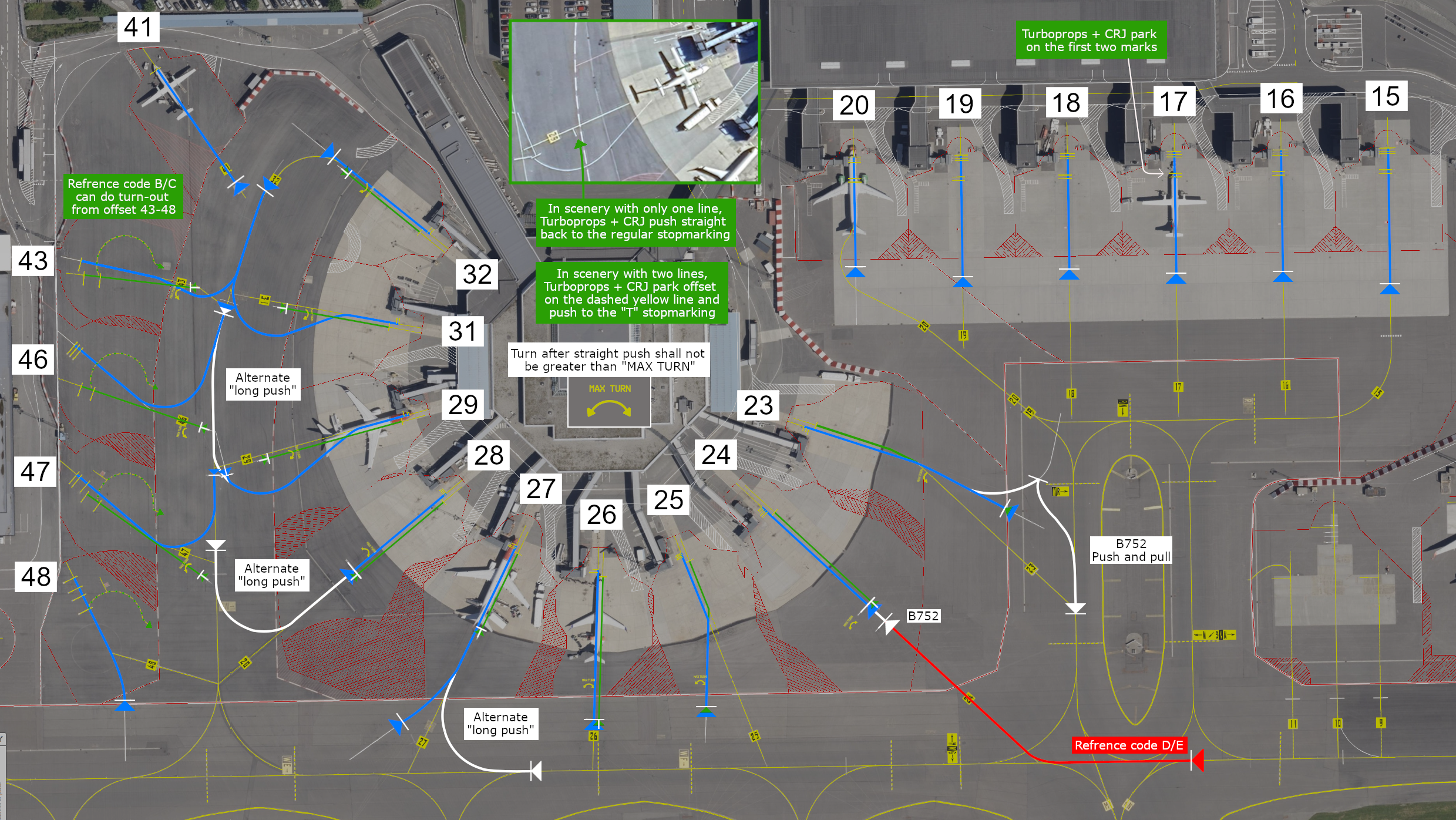
Most of the terminal gates require straight-back pushes. However, a few have turn pushes. In the map overview below, you will access all information:
Map Overviews
Terminal + Apron North (Stand 15-48)
Apron South (Stand 1-11)
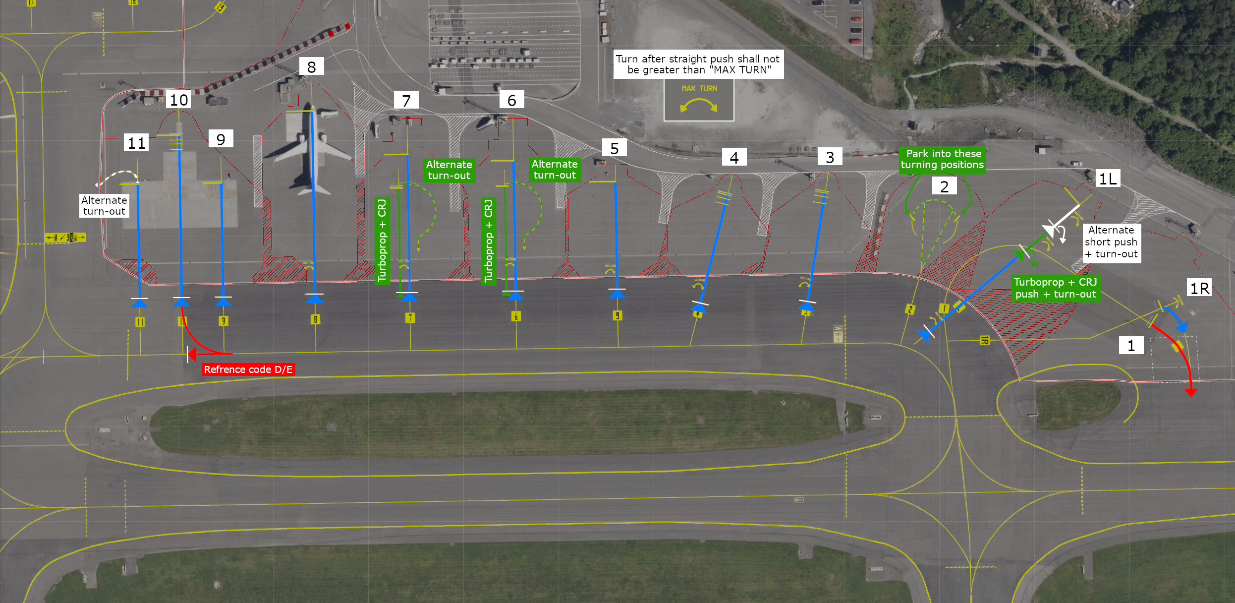
If the stand is not mentioned in the maps, ask the ground controller if you're unsure how to excecute the pushback
Taxi
Taxi instructions include the full taxi route, however the runway intersection will normally not be specified. Pilots are expected to taxi to the beginning of the runway; A1 (RWY 17) and A9 (RWY 35).
Aircraft with wake turbulence category light can expect taxi to interesection A2 (RWY 17) and A8 (RWY 35) during busy periods, and A4 (RWY 17) and A6 (RWY 35) when traffic permits.
Helicopters on Heli Apron can expect taxi to intersection A5 (RWY 17) and A6 (RWY 35).
Pilots are encouraged to state (preferably when on TWR frequency):
- Ready (or not ready) for departure, e.g.
READY [FOR DEPARTURE] (or NOT YET READY) - Acceptable or desired intersection for departure, e.g.
ABLE FROM A3 (or A2) (or [REQUIRE] FULL LENGHT)
Make sure to double-check if you are able to use the runway length from the intersection before requesting it.
Runways
There is a single runway available at ENBR, which is runway 17/35.
Helicopters may land on taxiway Y (parallel to the runway) if there are low traffic levels and good visibility conditions.
Please vacate the runway fully. This means the whole aircraft has crossed the stop bar line. If the aircraft is partly over and not fully, the consequences are that we might have to send aircraft around or delay them as the runway is not free.
SIDs
For all departures from Bergen, the initial climb is 6000ft, with the exception of helicopter SIDs. This initial climb altitude will always be included in your IFR clearance from ATC. It's crucial that you never climb above this initial altitude without ATC clearance, as STARs and SIDs intersect at various altitudes.
If you're unable to follow the published SIDs—perhaps due to an outdated AIRAC, a default aircraft, or freeware lacking a navigation database—you should request an Omni-directional departure. These are designated as OMNI3D and OMNI3C on the charts. While they might sound like standard SIDs, they are true omni-directional procedures. You'll find their details on the charts; they're not waypoint-dependent, so any aircraft can fly them regardless of its navigation database. Some aircrafts do allow you to select these departures in the FMS system, while others have to be flown with manual inputs.
Flesland automatically hands over departing aircraft after they pass 1500 feet. The ATIS will tell you who to contact.
- If ATIS reports "when passing 1500ft contact approach": Refer to your SID chart for the correct Approach frequency (either 121.0 or 126.1). Ignore any frequencies shown in your pilot client.
- If ATIS reports "when passing 1500ft contact Polaris Control frequency 123.456": Contact the provided Polaris Control frequency.
- If ATIS reports "when passing 1500ft monitor advisory 122.8": Switch to advisory frequency 122.8. This means there's no further ATC coverage.
If Tower tells you to "remain on my frequency," stay on the Tower frequency. This instruction is usually given when separation from other traffic isn't yet guaranteed. You must remain on Tower frequency until Tower explicitly tells you to contact the next sector.
Arrival and STARs
Before or at the initial phase of your descent, you will recessive your clearance for STAR and arrival. The arrivals contain many waypoints and restrictions. We recommend preloading the expected STAR and crosschecking so the correct fixes and restrictions have been loaded before descending. This helps you and the aircraft to plan the optimum descend profile and the start of the desende. Although remember to not start on the STAR unless you have been cleared by the controller.
Flesland is using a “Point Merge System”, or PMS. This means that all STARs end up in a “fan” made out of waypoints (RIVIP, GODID, GILVA, NEPAM), in which pilots should always be prepared for a direct routing towards the merge waypoint, 4 in total, in order to ease the workload of approach ATC.
Approach
Expect the ILS W approach at Bergen unless ATC/ATIS instructs otherwise.
The last fix of a STAR (or Merge Point) leads into a transition to the ILS approach for each runway. You are expected to fly the published transition. While ATC may issue vectors, particularly during high traffic periods, always be prepared to fly the transition and never fly direct from the merge point to the Final Approach Fix. If you don't have available transitions in your system, inform ATC and request vectors.
When you are cleared for the approach via GILVA, NEPAM, GODID or RIVIP transition, you are also cleared to continue the descent as long as the restrictions are followed. Usually, the restriction is 4000 feet or above at the transition point, but we recommend as always looking at your chart for the most precise information.
Following approach types is available in ENBR:
| Runway | Approach types |
|---|---|
| 17 | ILS W, LOC W, RNP Z, RNP (AR) E/N/S/W, VOR Helicopter only: ILS Y, LOC Y, RNP 139 |
| 35 | ILS W, LOC W, RNP Z, RNP (AR) E/N/W, VOR Helicopter only: ILS Y, LOC Y, RNP 043 |
1. RNP (AR) approaches should primarily be used outside of peak traffic times. RNP Z is available upon request.
2.Visual approaches are also an option. When flying a visual approach, do not descend below 2000 feet until established on final. Expect direct routing to specific points outlined in the visual approach chart when planning for these.
Direct routings
In Norway, direct routings are often used. Both arriving and departing traffic should be prepared to fly direct the end of SIDs, STAR Merge Points, and airspace border fixes. Make sure you have your filed route and waypoint page available to quickly accommodate direct routings.
Communications
You can always check online positions and sectors by visiting vatglasses.uk
ENBR_ATIS – Flesland ATIS – 125.255
ENBR_DEL – Flesland Delivery – 123.405
ENBR_P_GND - Flesland Ground Planner - 121.305
ENBR_GND – Flesland Ground – 121.905
ENBR_TWR – Flesland Tower – 119.105
ENBR_W_APP – Flesland Approach West – 121.005
ENBR_E_APP – Flesland Approach East – 126.105
ENBR_D_APP – Flesland Director – 118.855
ENSV_CTR – Polaris Control (Stavanger ACC) – 120.655
ENSV_N_CTR – Polaris Control (Stavanger ACC north) – 124.705
ENOR_CTR - Polaris Control (Bandbox) - 125.500
ENOR_S_CTR - Polaris Control (Bandbox South/Covering ENOS+ENSV AoR) - 121.550
ENOR_SC_CTR - Polaris Control (Bandbox South Central/Covering ENOS+ENSV+ENBD_S - 134.515
ENRC_S_CTR - Flesland Tower (Bodø Remote Tower Center) - 118.425
ENVA – Trondheim Værnes
Overview
Welcome to Trondheim! Home of the most flown domestic city pair together with Oslo. Also the home of "Hell", great moustache styling and rock. But do not forget the airport. It is the 3rd busiest airport in Norway as it is a domestic hub for commuters to the smaller airports in Norway. Trondheim host also several flight towards nordic and European destinations.
Stands
| Stands | Assigned to |
|---|---|
| 22-29 | Commuter Domestic |
| 30-37 | Domestic flights |
| 40-44 | International flights |
| Apron | Assigned to |
|---|---|
| M1 | De-Ice Pad |
| M2 | GA |
| M3 | Private jets Ambulance flights |
| M4-M6 | Military parking |
IFR clearance
Initial contact is with Ground, reporting callsign, stand number, and latest ATIS identification letter and QNH
Push-back
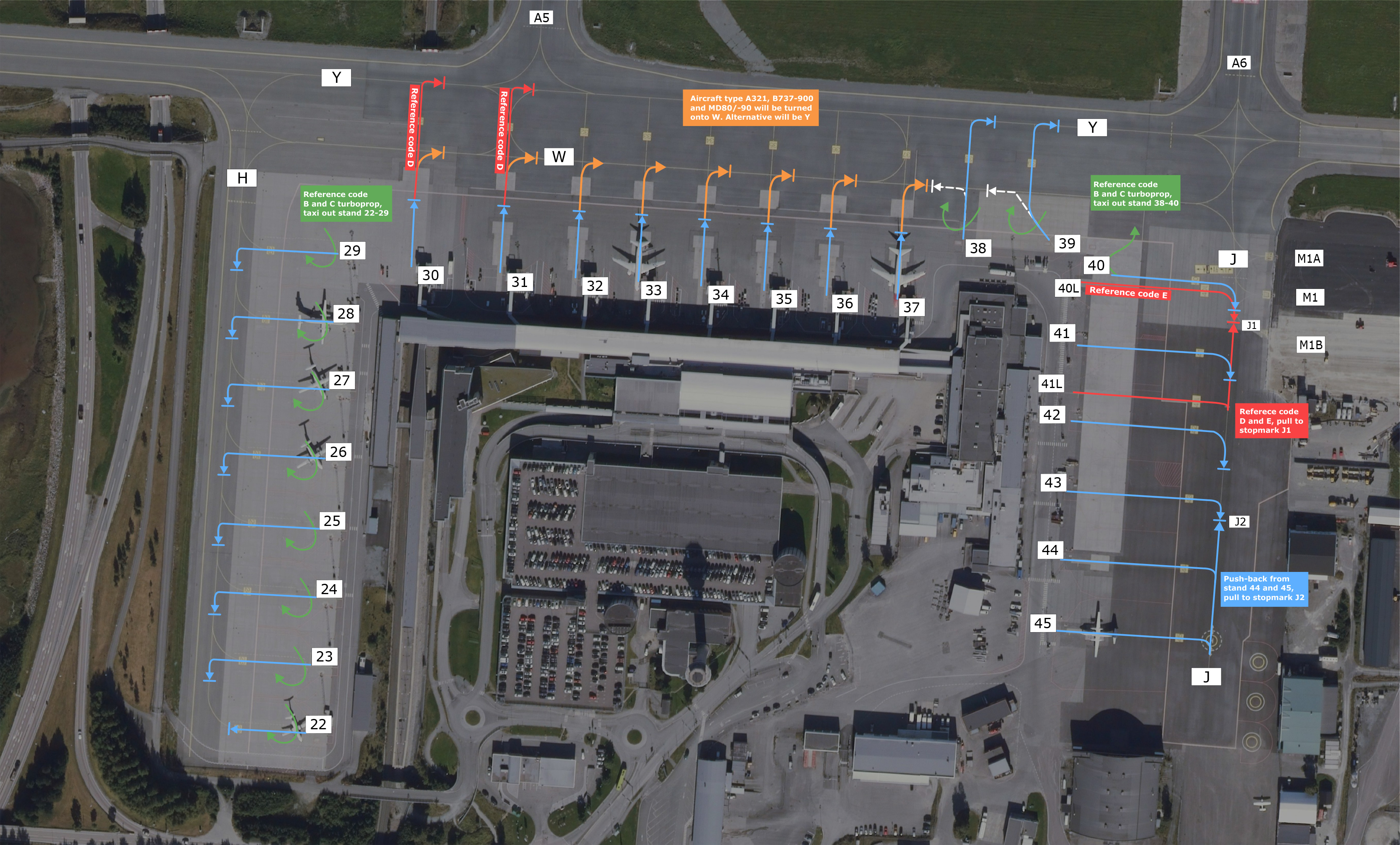
Most of the terminal gates requires straight-back pushes, however a few have turn-pushes. If you are not sure how pushback is excecuted from your stand, please have a look on the pushback maps witch will show how we want you to perform the pushback.
Pushback maps
Runway 09 in use
Runway 27 in use
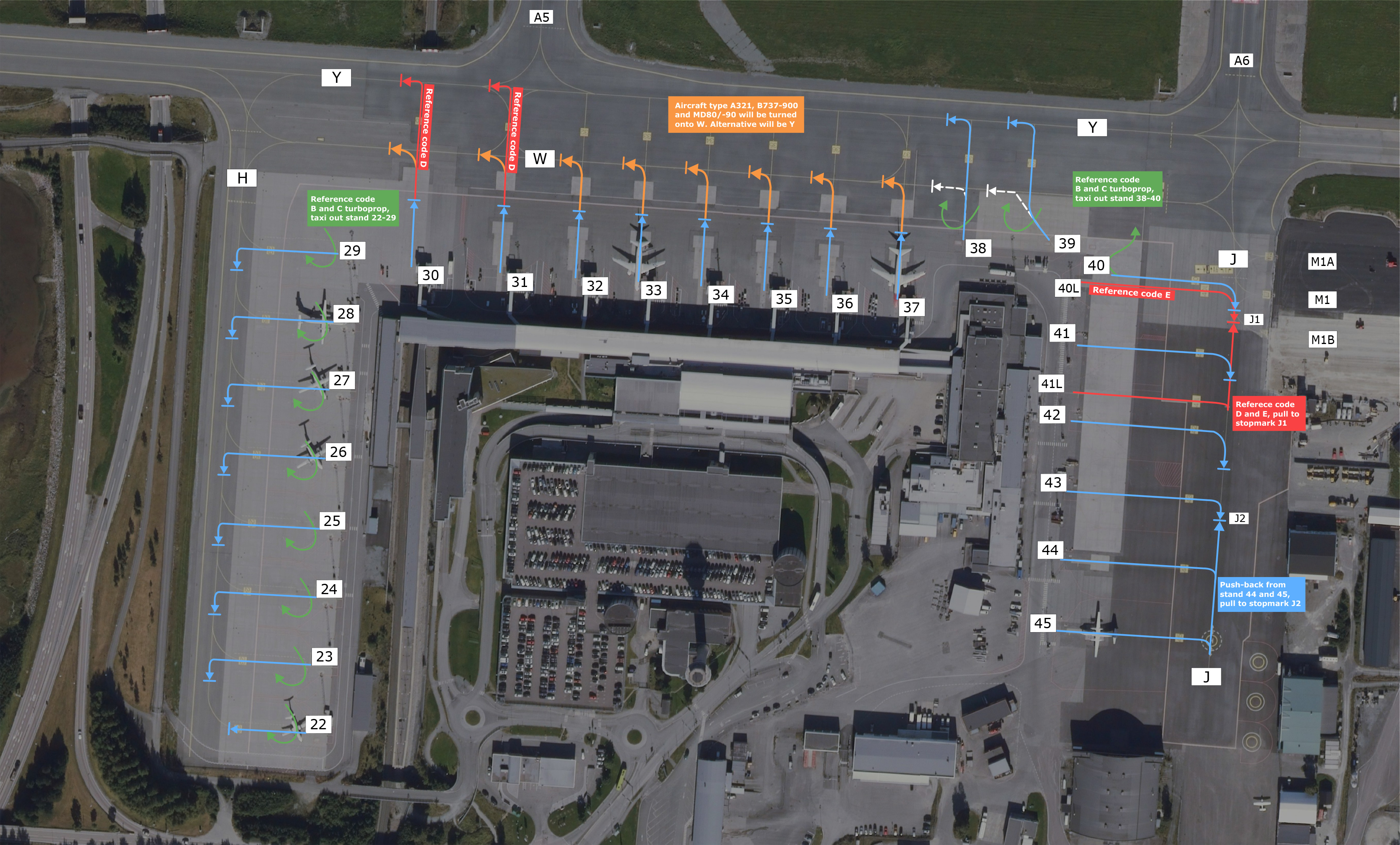 *Click on image to expand it's size
Taxi
Taxi instructions normally contains the full taxi route, however the runway intersection is not always included. If for example “holding point runway XX” is stated in your instruction, you may call ATC with “CALLSIGN, ready via ” as you approach this intersection, and it may be approved if traffic permits. Make sure to double-check if you are able to use the runway length from the intersection before requesting it.
SIDs
All SIDs are individually numbered for each runway. When receiving your clearance, know that the SID stated is only valid for one runway, in case the controller forgets to state the departure runway. RNAV SIDs (including OMNI-departure) has an initial climb altitude of 6000 ft. If you are unable to follow the published SIDs (old AIRAC, default or non-database freeware aircraft, etc.), request an Omni-directional departure. It is important that you NEVER climb above the initial climb without ATC clearance, as STARs and SIDs cross each other at different altitudes.
STARs
Trondheim Værnes is using a “Point Merge System”, or PMS for all arrivals. This means that all STARs end up in a “fan” made out of waypoints (study the STAR charts), in which pilots should always be prepared for a direct routing towards the merge waypoint, 4 in total, in order to ease the workload of approach ATC.
The last fix of the STAR (or Merge Point) is followed by a transition to the ILS approach for each runway. ATC often replace these with vectoring, but always be prepared to fly the transition, and do NOT fly direct from the merge point to the Final Approach Fix. If you have no transitions available, inform ATC and request vectoring. Study the approach charts, and make sure to always follow altitude and speed restriction, unless otherwise instructed by ATC
⚠️Recommended descend restrictions
All STARs to Trondheim are by standard giving a descend profile, based on flying along the STAR throughout. In almost all situations, a DCT to STAR merge point will be given. Therefore a set of recommended altitudes at given points is added to charts and text pages to guide and give an optimum descend profile to the approach. We highly recommend programming this in FMS/FMC in good time prior to your top of descend and pre-program your expected STAR
Runway 09
| Designator | Recommended Altitude |
|---|---|
| MIVSO xL | Cross VA414 at 7000 ft |
| NELSU xL | Cross VA414 at 7000 ft |
| NUPGO xL | Cross TUDLU at 7000 ft |
| VEVOD xL | Cross NEDIV at 7000 ft |
Runway 27
| Designator | Recommended Altitude |
|---|---|
| MIVSO xL | Cross ADEXA at FL 90 |
| NELSU xL | Cross ADEXA at FL 90 |
| NUPGO xL | Cross ALENU at FL 90 |
| VEVOD xL | Cross ADEXA at FL 90 |
Approach
The default approach to Værnes is ILS for all runways. RNP or visual approaches are available on request.
Visual approach is usually flown via MALOV (Runway 09) and TUSMO (Runway 27).
Direct routings
In Norway, direct routings are often used. Both arriving and departing traffic should be prepared to fly direct the end of SIDs, STAR Merge Points, and airspace border fixes. Make sure you have your filed route and waypoint page available to quickly accommodate direct routings.
Communications
You can always check online positions and sectors by visiting vatglasses.uk
ENVA_ATIS – Værnes ATIS – 127.555
ENVA_GND – Værnes Ground – 121.605
ENVA_TWR – Værnes Tower – 119.405
ENVA_APP – Værnes Approach – 118.605
ENVA_D_APP – Værnes Director – 119.155
ENBD_CTR – Polaris Control (Bodø ACC) – 126.450
ENBD_S_CTR – Polaris Control (Oslo ACC south) – 125.700
ENBD_C_CTR – Polaris Control (Bodø ACC central split) – 118.550
ENOR_SC_CTR - Polaris Control (Bandbox South Central/ENSV+ENOS+ENBD_S) - 134.515
ENOR_CTR - Polaris Control (Bandbox) - 125.500
ENRC_N_CTR - Værnes Tower (Bodø Remote Tower Center) - 118.325
ENZV - Stavanger/Sola
Overview
Welcome to Stavanger! The airport is located just outside the city south of the western coast of Norway.
Stands
| Stands | Section for |
|---|---|
| 17-24 | Domestic |
| 14-16 | Combined |
| 7-13 | International |
| 45-47 | GA |
| 50-64 | Helicopter |
| 25-27, 30-36, 301-303 | Cargo/GA |
De-Ice
When requesting startup, advise ATC if de-icing is required. This must be given over radio transmission only, not via DCL.
| Platform | Restriction |
|---|---|
| TWY P | Not available for ARC D or E |
| TWY Q | One ARC D or E ACFT |
When de-icing compleated and ready, contact ATC for taxi clearence.
IFR clearance
Initial contact is with Sola Ground, reporting callsign, stand number, and latest ATIS identification letter and QNH.
Flight level allocations
Flights from ENZV to ENBR & ENSO are to file EVEN flight levels below FL175.
SIDs
All SIDs are individually numbered for each runway. When receiving your clearance, know that the SID stated is only valid for one runway, in case the controller forgets to state the departure runway.
| Type | Inital climb |
|---|---|
| SID | 6000 ft |
| OMNI-SID | 5000 ft |
| SID (CAT H) | 2000 ft |
Push-back
Aircraft will be pushed to different disconnection positions (DPSN) based on stand and aircraft type:
- Standard pushback from stand 7-12 and 24 is a "long push and start" which implies straight pushback. Adjacent TWY will be closed for aircraft movement.
- Standard pushback from stand 13-22 is:
- DPSN 1 (ARC B-C): Straight push and start
- DPSN 2 ((ARC C-D) includes, but is not limited to A21N, 321, B752/3, MD83.): A "Long push and start" which implies straight pushback. Adjacent TWY will be closed for aircraft movement.
- Standard pushback from stand 7-19 ((ARC D-E) includes, but is not limited to A-332/3/8/9, A342/3/5/6, A359/1, B744/8, B762/3/4, B772/L/3/W, B788/9/J) is a "long push and start to align with TWY L". This implies that ACFT will be pushed to the centerline of TWY L, facing towards TWY R.
For detailed description, see AD 2 ENZV 2-4: "Push Back Procedures" in the AIP.
Taxi
Taxi instructions include the full taxi route however, the runway intersection is not always included. If for example “holding point runway XX” is stated in your instruction, you may call ATC with;
CALLSIGN, ready via B1
as you approach this intersection or with the taxi request, and it may be approved if traffic permits. Make sure to double-check if you are able to use the runway length from the intersection before requesting it.
Runways
Runway 18/36 is the main runway at Stavanger, Sola (ENZV). It will be used for all fixed-wings departures and arrivals as a favourable runway. If crosswind component exceeds aircraft limits, RWY 10/28 will be used.
Runway 18
| Intersection | TORA (m) |
|---|---|
| B1 | 2539 |
| B2 | 1830 |
Runway 36
| Intersection | TORA (m) |
|---|---|
| B4 | 2435 |
| RWY 10/28 | 1758 |
Runway 10/28 is used mainly for helicopter departure and arrivals. If strong crosswinds or low visibility, helicopters will land on RWY 18/36. The runway can also be used for departures and arrivals for fixed wing ACFT for operational reasons (crosswind, maintainainance etc.)
Runway 10
| Intersection | TORA (m) |
|---|---|
| D | 1646 |
| H | 1112 |
Runway 28
| Intersection | TORA (m) |
|---|---|
| F | 2193 |
| T | 1479 |
| H | 961 |
| D | 456 |
STARs
Study the approach charts, and make sure to always follow altitude and speed restriction, unless otherwise instructed by ATC.
STARs are available from BEGOD, IDIDI, KUNEM, RIVEX, ROPNO, UNBUD and UPDER for all runways.
Own CAT H STARs are available from EVOLO and UTERU for RWY 10, 18 & 36.
Approach
Sola has ILS, LOC and RNP approach for both runways. Visual approaches are also available and should not be flown below the ILS glide path or PAPI glide slope.
Communications
You can always check online positions and sectors by visiting vatglasses.uk
| Main logon | Frequency | Position |
|---|---|---|
| ENZV_ATIS | 126.005 | Sola ATIS |
| ENZV_TWR | 121.780 | Sola Ground |
| ENZV_TWR | 118.355 | Sola Tower |
| ENZV_APP | 119.405 | Sola Approach |
| ENZV_A_APP | 119.955 | Sola Arrival |
| ENSV_CTR | 120.655 | Polaris Control (Stavanger ACC) |
| ENOR_S_CTR | 121.550 | Polaris Control (Bandbox South/ENSV+ENOS) |
| ENOR_SC_CTR | 134.515 | Polaris Control (Bandbox South Central/ENSV+ENOS+ENBD_S) |
| ENOR_CTR | 125.500 | Polaris Control (Bandbox) |
ENTC – Tromsø Langnes
Overview
Tromsø is the biggest city in Northern Norway and is often called as “the Nordic answer to Paris”. The airport is located 3 kilometres from the city centre and is an important hub for the commuter network in Northern Norway. It also has international destinations within Europe. The surrounding area is spectacular and the approach into Tromsø is known for its steep approach down to the runway. Are you up for the challenge?
Stands
Available stands
Normal stand allocation is as followed:
Domestic: 21-25
International: 15-21
GA parks on the apron east of the runway
IFR clearance
Initial contact is with Tromsø Tower, reporting callsign, stand number, and latest ATIS identification letter and QNH.
Push-back
All pushback is executed straight back from the stand if it's not specified by the controller on pushback clearance.
Taxi
Taxi instructions at Tromsø include the full taxi route, however, the runway intersection is not always included. If for example “holding point runway XX” is stated in your instruction, you may call ATC with “CALLSIGN, ready via ” as you approach this intersection, and it may be approved if traffic permits. Make sure to double-check if you are able to use the runway length from the intersection before requesting it.
Runways
The runway (18/36) has a runway length of approximately 2400 meters. Medium and heavy aircraft are expected to backtrack on runway 18 for full length. Heavy aircraft may request a backtrack for full length on runway 36.
SIDs
All SIDs are individually numbered for each runway. When receiving your clearance, know that the SID stated is only valid for one runway, in case the controller forgets to state the departure runway.
All departures have an initial climb to FL90.
STARs
Study the approach charts, and make sure to always follow altitude and speed restriction, unless otherwise instructed by ATC.
STAR is available from LOMVI, KIIKA, DIBDI, AMIMO, GILGU, SJA (NON-RNAV, RWY 18), LURAP (NON-RNAV, RWY 36)
Holdings & rerouting during event
On major events such as Fly and See Santa, you have to expect holding and reroutings. We kindly ask and expect pilots to know the aircraft they execute rerouting and holdings in the specific aircraft. There are limited published holds. Expect to hold as published if there is a published hold. If not, holding instructions will be given.
Approach
Tromsø has an ILS, LOC and RNP approach for both runways.
The glide path is steeper than normal, so make sure to be established on a manageable speed before starting the approach. The Glide path angle is 4 degrees (7%)
Direct routings
In Norway, direct routings are often used. Both arriving and departing traffic should be prepared to fly direct to the end of SIDs, STAR Merge Points, and airspace border fixes. Make sure you have your filed route and waypoint page available to quickly accommodate direct routings. Pilots unable to fly direct, should make a comment regarding this in their Flight-Plan Remarks section.
ENTO - Torp Sandefjord
Overview
Welcome to Sandefjord! Home of the most flown domestic routes by Widerøe together with Bergen. The airport is located just south of Oslo Gardermoen together with Kjevik on the south easterly coast of Norway. Sandefjord has also several flights to the nordic and European destinations.
Stands
| Stands | Section |
|---|---|
| 1-2 | Combined |
| 3-5 | Domestic |
| 10-12 | Schengen |
| 13-15 | Non-schengen/International |
| 32-34 | GA |
| N, S | Deice |
IFR clearance
Initial contact is with Torp Ground, reporting callsign, stand number, and latest ATIS identification letter and QNH.
Push-back
All pushback is executed straight back from the stand if it's not specified by the controller on pushback clearance.
Taxi
Taxi instructions at Torp are given by Ground. When runway 36 is in use, you will get taxi to W1. If runway 18 is in use taxi will be given by Ground to either W2 for crossing or W3 for back-track. Further taxi instrutions will be given by Torp Tower.
Runways
Runway (18/36) has a runway length of approximately 2800 meters. During runway 18 operation aircrafts will get taxi to holding point A via C or instructions to back-track the runway.
SIDs
All SIDs are individually numbered for each runway. When receiving your clearance, know that the SID stated is only valid for one runway, in case the controller forgets to state the departure runway.
All departures have an initial climb to 4000FT.
STARs
Study the approach charts, and make sure to always follow altitude and speed restriction, unless otherwise instructed by ATC.
STARs are available from BAMIX, VATEX, REPKU, ESOSI, ULMUG (RWY 18/36)
Approach
Torp has and ILS, LOC, RNP and VOR approach for both runways. Visual approaches are also available if the weather criterias are met.
Communications
You can always check online positions and sectors by visiting vatglasses.uk
| Main logon | Frequency | Position |
|---|---|---|
| ENTO_ATIS | 119.080 | Torp ATIS |
| ENTO_GND | 126.180 | Torp Ground |
| ENTO_TWR | 118.655 | Torp Tower |
| ENTO_APP | 134.055 | Farris Approach |
| ENTO_D_APP | 124.355 | Farris Director/VFR |
| ENOS_CTR | 127.255 | Polaris Control (Oslo ACC South) |
| ENOS_N_CTR | 120.380 | Polaris Control (Oslo ACC North) |
| ENOR_S_CTR | 121.550 | Polaris Control (Bandbox South/Covering ENOS+ENSV) |
| ENOR_SC_CTR | 134.515 | Polaris Control (Bandbox South Central/Covering ENOS+ENSV+ENBD_S) |
| ENOR_CTR | 125.500 | Polaris Control (Bandbox) |
| ENRC_S_CTR | 118.425 | Gardemoen Tower (Bodø Remote Tower Center) |
ENCN - Kristiansand Kjevik
Overview
Kristiansand Airport (Kjevik) is located on Norway's southern coast and serves the southern region. It offers flights to various Norwegian and European destinations including Oslo, Bergen and Amsterdam.
Stands
| Apron | Suggested Parking |
|---|---|
| Stand 10 | International (ARC D) |
| Stand 11 | International (ARC C) |
| Stand 12 | Domestic/International (ARC C) |
| Stand 17-13 | Domestic Flights (ARC C) |
| Stand 18 | Business jets |
| Stand 19 | Business jets / Cargo (ARC D - Max wingspan 42 M) |
| Apron S (31-38) | GA |
| Apron O (42-48) | GA |
De-Ice
Kjevik Airport has only one de-icing platform, south of taxiway Y. Taxiing to and from the platform requires ATC clearance, even outside the maneuvering area. Pilots should exercise caution when taxiing.
| Platform | Restriction |
|---|---|
| De-Ice | One ARC C or D ACFT |
Business jets may use the stands east of de-ice for parking outside of winter operations.
IFR clearance
Initial contact is with Kjevik Tower, reporting callsign, stand number, and latest ATIS identification letter and QNH.
Push-back
Pushback is straight back from all stands unless the controller specifies otherwise during pushback clearance.
Taxi
Tower provides taxi instructions. For RWY 03, expect taxi to holdingpoint A. For RWY 21, expect taxi to holdingpoint B with runway backtracking.
Runways
Runway (03/21) has a runway length of approximately 2000 meters. During runway 03 operation aircrafts will get taxi to holding-point A via Y. During 21 operations you will get instructions to back-track the runway from B.
SIDs
All SIDs are individually numbered for each runway. When receiving your clearance, know that the SID stated is only valid for one runway, in case the controller forgets to state the departure runway.
All departures have an initial climb to 5000FT.
STARs
Study the approach charts, and make sure to always follow altitude and speed restriction, unless otherwise instructed by ATC.
STARs are available from AMSEV, LANTI, OSVAL, RASVI, TIPSO, PEVEB (RWY 03/21)
All STARs terminate at a transition fix. If cleared for an ILS approach, follow the ILS transition route depicted on the ILS charts.
Approach
ILS, LOC, and RNP approaches are available for both runways. Due to noise abatement, visual approaches must follow the PAPI slope when below 1500ft.
Communications
You can always check online positions and sectors by visiting vatglasses.uk
| Main logon | Frequency | Position |
|---|---|---|
| ENCN_ATIS | 124.475 | Kjevik ATIS |
| ENCN_TWR | 118.105 | Kjevik Tower |
| ENCN_APP | 119.955 | Kjevik Approach |
| ENOS_CTR | 127.255 | Polaris Control (Oslo ACC) |
| ENOS_8_CTR | 134.350 | Polaris Control (Oslo ACC Sector 8) |
| ENOR_S_CTR | 121.550 | Polaris Control (Bandbox) |
| ENOR_SC_CTR | 134.515 | Polaris Control (Bandbox South Central/ENSV+ENOS+ENBD_S) |
| ENOR_CTR | 125.500 | Polaris Control (Bandbox) |
General recommendations
General recommendations
When flying within Polaris FIR, some small things can make the experience great for everyone. Here is some great advice from the controllers in Polaris FIR:
Read the frequency
This may sound strange and a bit harsh, but it is essential for our controllers in busy events. If you do not read the room (or in this case frequency), you will most likely cause more stress for both controllers and your fellow pilots. Therefore make sure to:
- Listen to the frequency before checking in. Audio for VATSIM can be a bit slow on frequency change during high-load
- If you are requesting clearance when it is busy, please do not try to force into the frequency for a clearance. Once we get some aircraft departed, the frequency will quickly be calmer, so please be patient.
Be prepared
We can not say this enough - we all win by doing this. It is not unusual for us to issue an instruction that is far ahead in time, such as giving direct routing to a waypoint on the approach while still on a cruise. So make sure to prepare your charts and brief yourself before departure and landing.
Pushback
Taxi
Taxi clearances to the runway are often given without a specific holding point. If it's the case, taxi to the most reasonable holding point. In most cases, this will be at the end of the runways or the locations which give the shortest backtracks.
IFR Departure
When airborne and contacting approach, establish the communication by:
- Call up with callsign
- Report the current altitude
This is to establish both communication and verify data that what we see on the radar is your aircraft. If you don't report your altitude, we have to ask so by saying it on intial call saves time.
If traffic permits, you can expect a direct to a waypoint along your route, also beyond the end of the SID. In short domestic flights, even a direct to the IAF (Initial Approach Fix) or waypoint on the expected star is not unusual. If you have a short flight time, we recommend to pre-plan and pre-program the expected arrival and approach before departing from the departure field.
IFR Arrival
An arrival clearance will be given before the end of your routing. A STAR and expected approach will be issued. A confirmation of what approach you can expect will be issued by approach on initial contact. If your destination does not have a STAR, expect vectors or direct to the respective points on the approach.
Some do and don't on arrival:
Descend
Directs and vectoring
Speed control
Cleared for approach?
Flying aircraft with CODE F
Norway has a handful of airports serving different types of aircrafts. But when it comes to CODE F aircraft (for example A380 & B747-8), there are limitations on most of our airfields. The only airfield with documented CODE F procedures is Oslo Airport (ENGM). All pilots are highly encouraged to follow published charts and procedures on AIP, witch is also in accordance with VATSIM Code of Conduct (CoC). If there are no published CODE F procedures to intended airport, the aerodrome is likely to not be capable to handle your aircraft. ATC will always advise if you are uncertain about this when it comes to different airport's capabilites.
Flying into AFIS Aerodromes
In Norway we have smaller airports with Traffic Information Areas (TIA) and Traffic Information Zones (TIZ). These are uncontrolled airspaces (class G) due to them being less busy. Hence, only AFIS is provided and it's the pilots responsibility to avoid collisions within these airspaces.
Two-way radio contact with AFIS is mandatory. The AFIS unit will provide runway in use, weather conditions and traffic information.
Simplified summary for pilots
- "Runway occupied" means someone else is using the runway to depart or land, you must give way. Respond to such calls with your intention to give way/hold position/orbit/route behind as appropriate. You are the PIC, you decide what the best course of action is.
- "No reported traffic runway XX" means you are free to use the runway to depart or land.
- Establish two-way radio contact before entering TIZ/TIA (have your callsign and message acknowledged by ATC/ATS).
- When departing, report before starting/pushing/taxiing, and don't initiate this action before ATS have had a chance to respond with relevant information if any.
- When AFIS units are online, their callsign is "[Airport] Information".
- Norwegian AFIS airports are covered by overlying APP/CTR controllers when the AFIS unit is offline. If in doubt, ask via PM.
- Obtain your IFR clearance from the AFIS unit (when online), they will coordinate with ATC.
- Make safe and sensible decisions as PIC. Keep in mind these laws and common practices:
- Landing aircraft have priority over departing aircraft.
- VFR aircraft should generally give way to IFR and commercial operations. This is not law, but the VFR pilot is almost always inconvenienced far less by making short delays than IFR and airline ops.
More in-depth information and examples of procedures are available in the AFIS Guide for ATC.
Report broken or outdated content
If you find any broken or outdated links, pages, documentation and similar. Do not hesitate to report it to norway@vatsim-scandinavia.org.
Airport Sceneries
ENBR | Bergen Flesland
| Simulator | Freeware/Payware | Scenery | Remark |
|---|---|---|---|
| Microsoft Flight Simulator (MSFS) | Freeware | WombiiActual (Flightsim.to) | Our recommendation |
| Payware | Bergen Airport (RDdesign) | Incorrect runway slope | |
| ENBR Bergen Flesland Airport (Salvuz) | |||
| X-Plane (XP11+XP12) |
Freeware | Default Gateway | |
| Payware | Bergen Airport XP (Aerosoft) | ||
| Prepar3D (P3D) Flight Simulator X (FSX) |
Freeware | Airports of Norway (AoN) | |
| Payware | Bergen Airport X (Aerosoft) |
ENGM | Oslo Gardermoen
| Simulator | Freeware/Payware | Scenery | Remark |
|---|---|---|---|
| Microsoft Flight Simulator (MSFS) | Freeware | Oslo Airport (Flightsim.to) | Our recommendation |
| Payware | ORBX Oslo | ||
| Mega Airport Oslo-Gardemoen (Aerosoft) | |||
| X-Plane (XP11+XP12) |
Freeware | Default Gateway | |
| Payware | Airport Oslo XP (Aerosoft) | Not recommended due geo offset | |
| ENGM - Oslo Airport Gardemoen (Taimodels) | |||
| Prepar3D (P3D) Flight Simulator X (FSX) |
Freeware | Airports of Norway (AoN) | |
| Payware | Mega Airport Oslo X (Aerosoft) | Not recommended due geo offset |
ENTC | Tromsø Langnes
| Simulator | Freeware/Payware | Scenery | Remark |
|---|---|---|---|
| Microsoft Flight Simulator (MSFS) | Freeware | donutsdemise (Flightsim.to) | Old layout/terminal |
| artogsta (Flightsim.to) | |||
| Payware | M'M Simulations (Flightsim.to) | ||
| X-Plane (XP11+XP12) |
Freeware | Default Gateway | |
| Payware | Tromsø Airport XP (Aerosoft) | ||
| Prepar3D (P3D) Flight Simulator X (FSX) |
Freeware | Airports of Norway (AoN) | |
| Payware | Tromsø Airport X (Aerosoft) |
ENVA | Trondheim Værnes
| Simulator | Freeware/Payware | Scenery | Remark |
|---|---|---|---|
| Microsoft Flight Simulator (MSFS) | Freeware | ENVA Trondheim Værnes (Flightsim.to) | |
| Payware | Aerosoft Værnes | ||
| X-Plane (XP11+XP12) |
Freeware | Default Gateway | |
| Prepar3D (P3D) Flight Simulator X (FSX) |
Freeware | Airports of Norway (AoN) | |
| Payware | Aerosoft Vaernes |
Norway Offshore Guide
Introduction
Norway sees a lot of offshore helicopter traffic related to the oil and gas industry. Civil helicopters operate from onshore bases (ENHF, ENBN, ENKB, ENFL, ENBR and ENZV) to, from and between fixed and moveable installations on the Norwegian Continental Shelf. Offshore operators also fly SAR missions on contracts from the norwegian government.
Offshore helicopter procedures are somewhat specialized and tailored to the risks and challenges involved with flying far out over the seas in harsh enviroments. This guide is intended as a simplified summary of the unique helicopter procedures, flight planning considerations and radiotelephony used in offshore flying, for both pilots and ATC.
Sources: Avinor Helicopter Manual, AIP Norway, EASA EAR for Air OPS, FAA AC 90-80C, Helicopter Approach to Offshore Objects
General
Flightplan requirements
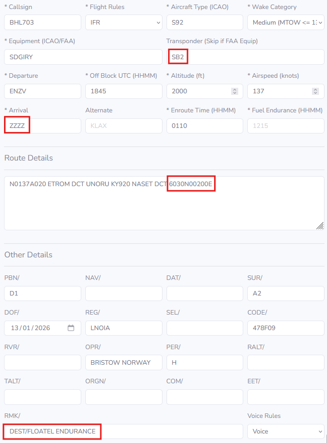
ADS-B capability must be indicated in the flightplan by adding B1 or B2 to the transponder equipment code.
Flight plans to sea vessels/temporary installations not given a ENxx identifier, shall have ZZZZ as destination, coordinates of the vessel at the end of the route, and DEST/NAME OF VESSEL added to the remark field.
Example flight plan
Free Routes
Helicopters with operative ADS-B transponder can normally file from SID-endpoint DCT destination, DCT between installations offshore or from offshore installations DCT STAR start point or IAF (see Note for ENBR arrivals).
Helicopter routes are described below. They must be used when a/c does not have a functioning ADS-B transponder (when exemption is given from either NCAA or from the ATS unit for single flights) or when ATM service is downgraded (due reduced COM/SUR etc).
Note: Arrivals to ENBR: Helicopter STARs are dependent on Runway in use at ENBR. FPLs shall be filed DCT TMA boundary fix. Expect routing/clearance direct STAR start point for Runway in use when traffic permits.
Helicopter Routes
Helicopter Routes (HR) are established in the parts of the North Sea, Norwegian Sea and the Barents Sea where Norway is responsible for providing ATS (REF AIP Norway GEN 3.3).
A HR is an ATS-route frequently used by civil helicopters, along which control and flight information service may be provided. They can be directional or bi-directional.
Civil helicopters will normally operate direct destinations from 500 FT AMSL to FL 80, but will follow an HR if the situation requires so.
Example of helicopter routes in South Norway
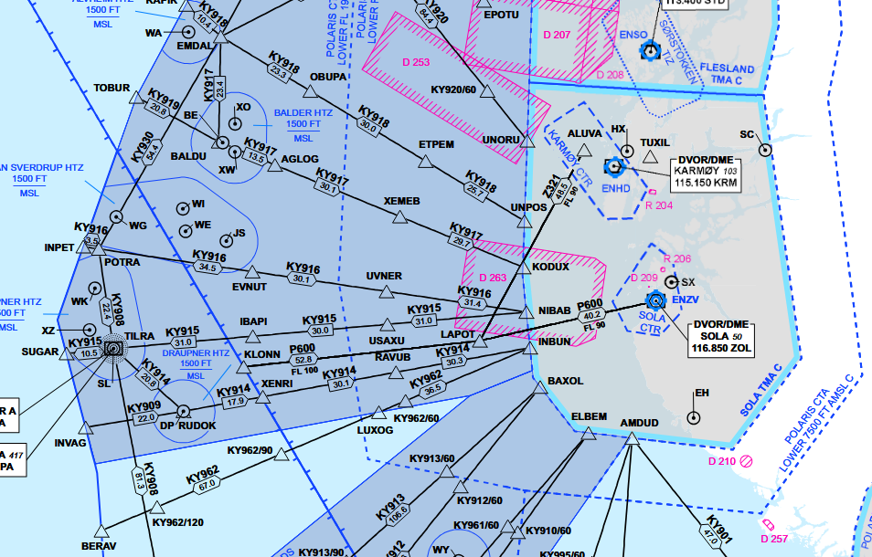 Ref. AIP ENR 6-23 | Offshore Helicopter Area - Southern Norway
Cruising Altitudes
Civil helicopters operating to and from offshore installations will normally be operating at the following altitudes, based on actual QNH/forecast minimum:
| Magnetic track | Altitude |
|---|---|
| 000 ̊ - 179 ̊ | ODD levels 3000 FT or above |
| 180 ̊ - 359 ̊ | EVEN levels 2000 FT or above |
If weather conditions or other circumstances necessitate operations below 2000 FT, the following altitudes based on radar altimeter will normally be used.
| Magnetic track | Altitude |
|---|---|
| 000 ̊ - 179 ̊ | 1000FT |
| 180 ̊ - 359 ̊ | 500FT |
Altimeter setting
QNH setting areas are based on actual QNH. The exception is Bjørnøya ASR, where a forecast minimum QNH is used. A change to a new QNH shall be carried out when instructed by ATS, as this may have implications on separation from other aircraft.
Transition altitude is 7000 FT. For flights at 1000 FT or below, radar altimeter shall be used.
Example of QNH Areas in Southwest Norway
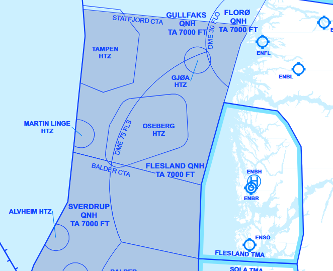 Ref. AIP ENR 6-30 | QNH Setting Areas - Southwest Norway
Example of QNH Areas and Altimeter Setting Regions in North Norway
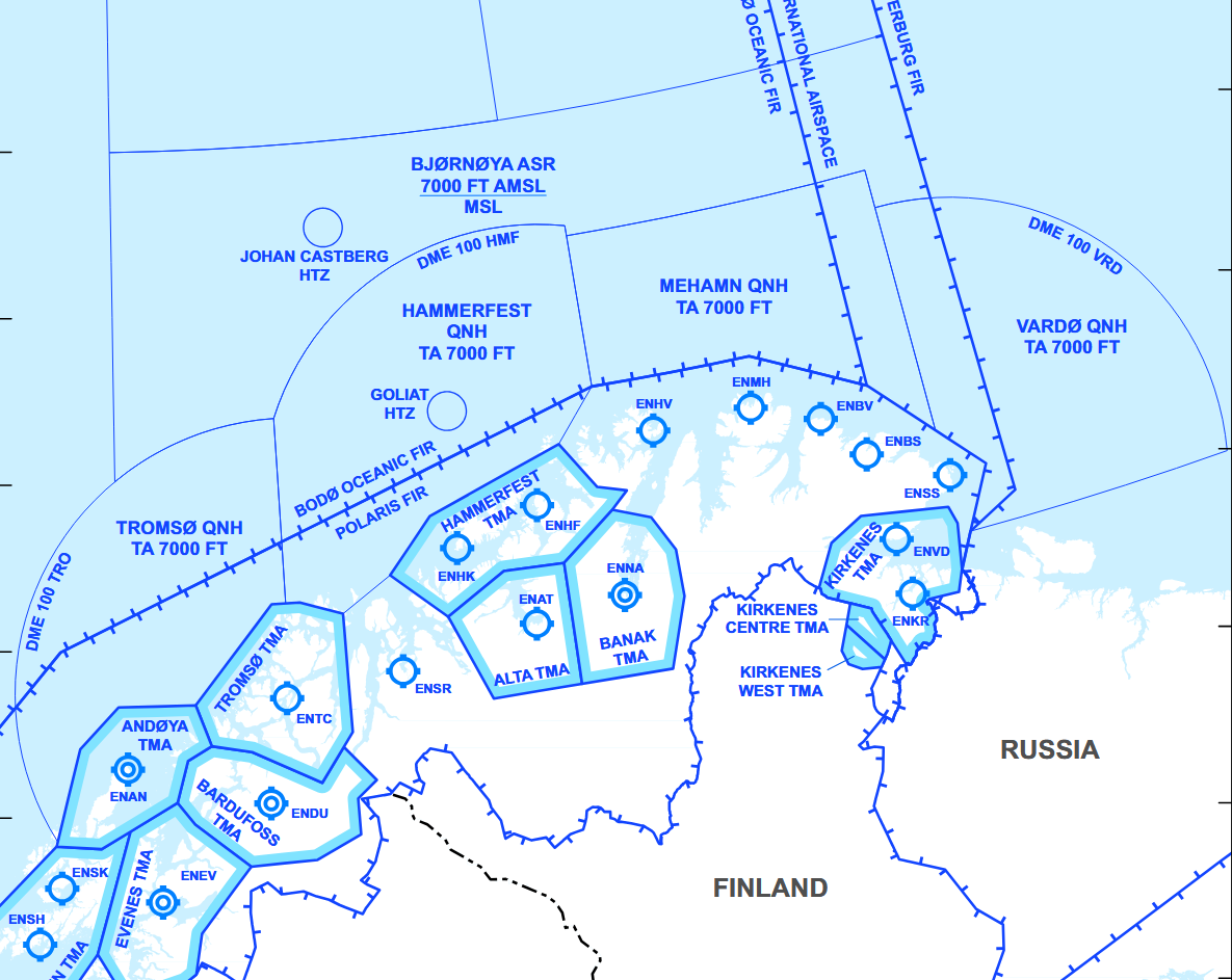 Ref. AIP ENR 6-32 | QNH Setting Areas - Barents
ADS areas
ADS areas are defined areas of Class G airspace, either below a CTA (MSL – 1500 FT), or a specific area (MSL – FL 085) between the main land bases and the main oilfields where surveillance based ATS is provided to participating helicopters.
Example of ADS Area without CTA
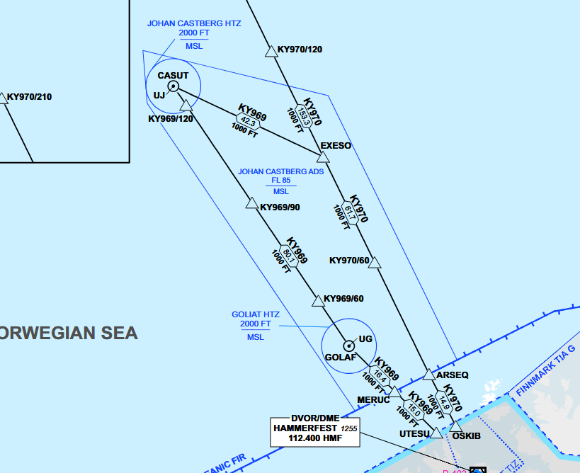 Ref. AIP ENR 6-25 | Offshore Helicopter Area - Northern Norway
Control Areas (CTA)
Defined Control Areas are established on the Norwegian continental shelf with Class-D Airspace, from 1500 FT- FL085. Heidrun CTA is established in the Norwegian Sea. Statfjord CTA, Balder CTA and Ekofisk CTA are established in the North Sea.
Example of CTA with ADS Area below
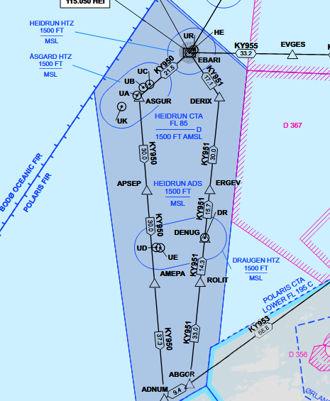
Ref. AIP ENR 6-24 | Offshore Helicopter Area - Southern part of Mid-Norway
Helicopter Traffic Zones (HTZ)
A HTZ is established at all permanent offshore installations on the Norwegian continental shelf within a radius of 7 NM from the landing pad and comprises the airspace between MSL and 2000 FT, or to the lower limit of a CTA. Around groups of two or more installations, and with distance of less than 10 NM from each other, a common HTZ is established with the border tangential to a 7 NM radius from the landing pads.
Helicopter Traffic Zones are Radio Mandatory Zones (RMZ) and two-way radio contact must be established with the approriate ATS-facility before entry.
Example of Tampen HTZ
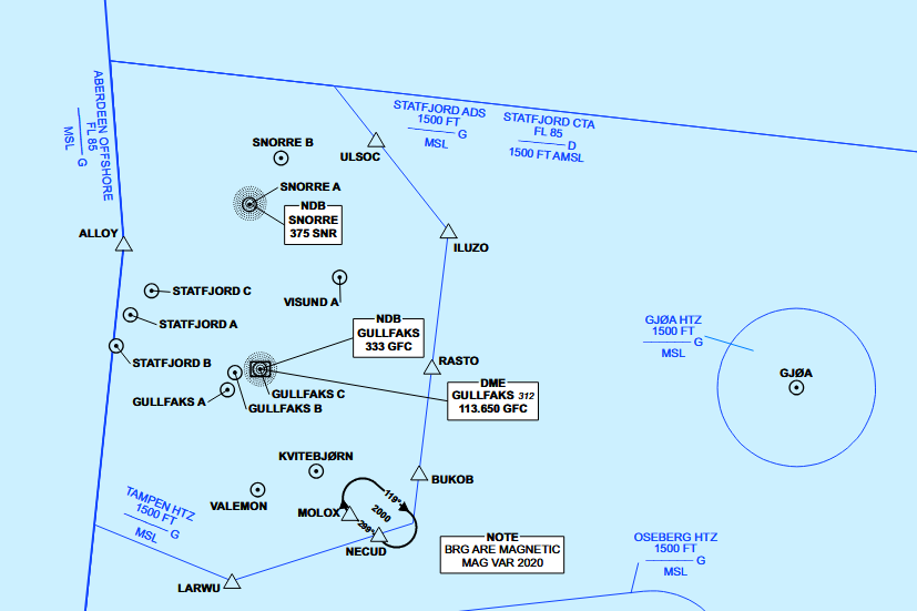 Ref. AIP ENR 6-27 | Helicopter Traffic Zone (HTZ) Part 2
METAR
Offshore platform METARs contain some additional parameters that are not found on shore.
- Sea surface temperature in degrees celsius = Wxx/Sxx
- State of the sea = Wxx/Sx
| WMO Sea state code | Wave height | Charasteristics |
|---|---|---|
| 0 | 0 metres (0 ft) | Calm (glassy) |
| 1 | 0 to 0.1 metres (0.0 to 3.9 in) | Calm (rippled) |
| 2 | 0.1 to 0.5 metres (3.9 in to 1 ft 7.7 in) | Smooth (wavelets) |
| 3 | 0.5 to 1.25 metres (1 ft 8 in to 4 ft 1 in) | Slight |
| 4 | 1.25 to 2.5 metres (4 ft 1 in to 8 ft 2 in) | Moderate |
| 5 | 2.5 to 4 metres (8 ft 2 in to 13 ft 1 in) | Rough |
| 6 | 4 to 6 metres (13 to 20 ft) | Very rough |
| 7 | 6 to 9 metres (20 to 30 ft) | High |
| 8 | 9 to 14 metres (30 to 46 ft) | Very high |
| 9 | Over 14 metres (46 ft) | Phenomenal |
Example:
ENQA 151850Z 18029KT 9999 -SHRA BKN019/// BKN110/// 07/05 Q0996 W08/S5=
Communication
Air Traffic Service
Air traffic service provided for helicopter operations on the Norwegian continental shelf:
Southern Norway
| Area | Service | Provided by |
|---|---|---|
| Statfjord CTA | Air Traffic Control | Polaris ACC Stavanger |
| Balder CTA | ||
| Ekofisk CTA | ||
| Statfjord ADS | Flight Information | |
| Balder ADS | ||
| Balder ADS | ||
| Tampen HTZ | Tampen FIS | |
| Ekofisk HTZ | Ekofisk FIS | |
| HTZ | Polaris ACC Stavanger |
Middle and Northern Norway
| Area | Service | Provided by |
|---|---|---|
| Heidrun CTA | Air Traffic Control | Polaris ACC Bodø |
| Heidrun ADS | Flight Information | |
| Norne ADS | ||
| Barents Sea | ||
| HTZ |
In all cases, surveillance service is also provided when available.
Radio communication
Startup
For departure from installations within HTZ with HFIS, the HFIS unit shall be notified of the estimated time of departure (ETD) of the flight at start-up.
- HFIS may relay enroute clearances to the pilot from Polaris ACC before lift-off.
- Enroute clearances are not required if the entire flight will remain in uncontrolled airspace.
Pre-lift-off report
Prior to lift-off from any installation, pilots shall deliver a pre-lift-off report to the appropriate ATS unit, and shall contain:
- Callsign
- Location
- Intended route
- Intended altitude or level
The appropriate ATS unit shall provide traffic information before lift-off is initiated.
NOR123, ready for lift, Gullfaks C to Flesland, via flight planned route, 3000ft
NOR123, ready for lift, Gullfaks C to Martin Linge via NEBAV direct NASET, 2000ft
Airborne report
If not covered by other procedures, after take-off from an offshore installation, pilots shall deliver an airborne report to the appropriate ATS unit as soon as practicable, and shall contain:
- Callsign
- Actual time of departure (ATD) from installation
- Actual/intended altitude or level
- If routing via HR and no surveillance service is provided: ETO next reporting point and entry point TMA/TIZ.
NOR123, airborne Gullfaks C at 55, passing 600, climbing 1500
NOR123, airborne Ekofisk L at 31, passing 700, climbing 1000, estimate AGUVI at 36, ELBEM at 1820
On-deck report
After landing on an installation, pilots shall deliver an on-deck report to the appropriate ATS unit, and shall contain:
- Callsign
- Name on the installation
- Actual time of arrival (ATA)
- Additional information if required (e.g. refueling, shut down)
NOR123, on deck, Gullfaks C at 50
NOR123, on deck, Gullfaks C at 1450, shutting down
ARA
If planning an Airborne Radar Approach, pilots shall inform the appropriate ATS unit of the following information:
- ARA to (destination)
- Final inbound course
- Course in case of Missed Approach
- Will call passing IP
NOR123, intentions to do an A R A to Ula, inbound course 040, missed approach left turn on course 355, will call passing I P
Operations within a HFIS HTZ
Standard calls while operating within a HFIS HTZ:
- Pre-lift-off report
- Airborne report
- On deck report
During marginal weather conditions, additional information to the standard calls above shall be made when applicable:
- Departure heading and altitude
- Intentions
- ARA
Shuttle (inter-rig flights)
For shuttle flights between adjacent rigs, the Pre-lift-off report and Airborne report are combined into a simplified Liftoff report that shall contain:
- Callsign
- Departure installation
- Destination
- POB
When landed, pilots shall report on deck and omit the time.
NOR123, lifting, Troll C to Troll B, 5 POB
NOR123, on deck, Troll B
Enroute and approach to an oil field
Outbound traffic from landbase to offshore destination, shall give an estimate for an entry point (HTZ) or destination rig on the initial call to ACC.
On initial contact for flights inbound to an oilfield, the initial call or position report shall contain:
- Callsign
- ATIS Information letter (if available)
- Position
- Altitude
- Estimate time over (ETO) point of entry
- Intentions: Visual approach direct to (destination) / Cloud break, direct to (destination) / ARA
- ETA destination
Polaris control, NOR123, with Gullfaks information A, inbound NECUD, 2000ft, estimate NECUD at 40, intentions to do a visual approach direct to Kvitebjørn, estimate Kvitebjørn at 50
Enroute and approach to a land base
Per agreements between ATS and operators, the initial call with the APP facility at the airport shall contain:
- Callsign
- ATIS Information letter
- Position
- Altitude
- Intended/requested approach, or
- Intentions to cancel IFR flight and proceed VFR, and
- Canceling IFR
Flesland Approach, NOR123, Weather A, Inbound VENIN, 3000ft, request RNP 043.
Flesland Approach, NOR123, Weather E, Inbound VENIN, 3000ft, intention is to cancel IFR.
NOR123, visual, cancelling IFR flight.
Position reporting
A Position Report shall contain:
- Call Sign
- Position and Time
- Altitude
- ETO next Reporting Point
- Next Reporting Point if it is a special point
In areas with HR: a HR must be followed if without surveillance service, and position reports shall be transmitted at each reporting point.
- Helicopter routes are identified by the letter KY (called «Copter”) and route number, e.g. KY915.
- Reporting points are identified by:
- a 5 letters identification (e.g. NECUD), or
- letters KY + route number + distance from an onshore DME (e.g KY915/90).
- Phraseology to be used is ”route number + distance” (e.g. ”Copter Niner One Five – Niner zero”)
NOR123, passing Copter 915 – 60 at 01, 2000ft, estimate 90 at 31
NOR123, passing Copter 915 – 90 at 15, 2000ft, estimate 120 at 30, SUGAR next
In areas without HR: FPL-route must be followed if without surveillance service, and position reports shall be transmitted every 30NM.
NOR123 is position 72 north 15 east at 1002, 2000ft, estimating 73 north, 15 east at 1016
Helicopter procedures
Onshore
IFR Procedures
Except some minor differences, instrument flying is very similar for both fixed and rotary wing aircraft. Rules followed by rotary and fixed wing pilots after take-off until final approach are almost the same.
The major differences come up with the operational concerns. For example, special take-off and landing minimums dedicated for helicopters allow them to take-off and land in lower visibility conditions.
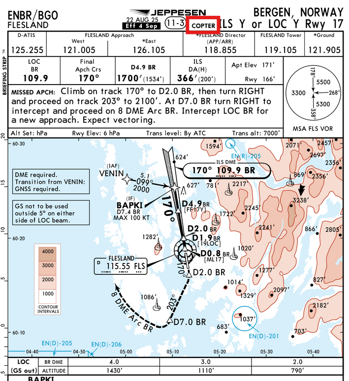
If requested by ATC, helicopters are obliged to comply with every necessities stated in standard departure and approach procedures. However, if available to the pilot, helicopter specific procedures will normally be offered.
Example of Copter only apparoaches
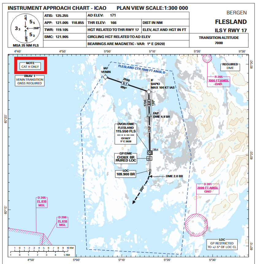
PinS - Point in Space
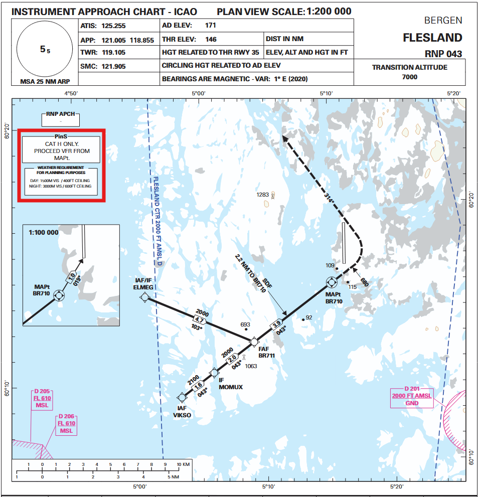
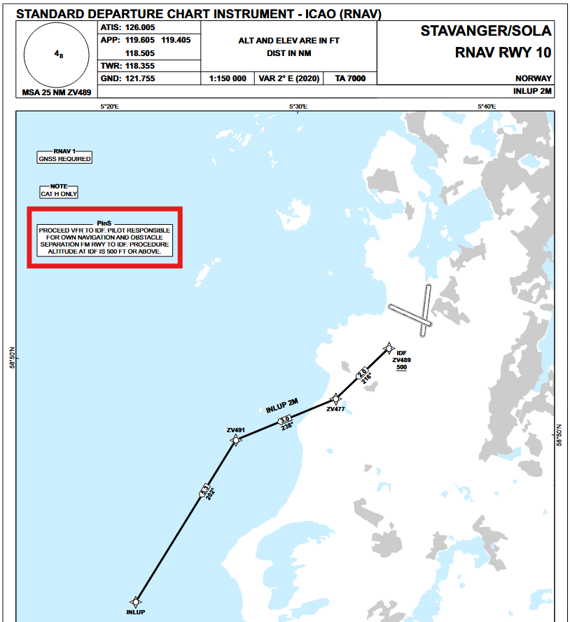
The Point-in-Space (PinS) concept is a flight operation based on GNSS and designed for helicopters only. It relies on the possibility for the pilot to conduct flight under IMC to/from a PinS (point in space) and not directly to/from the heliport.
PinS procedures are established as both approach and departure procedures in Norway.
Example of PinS procedures
Offshore
VFR Minimums
When using an offshore location as a destination or alternate, during the period between 1 hour before and 1 hour after expected time of arrival, weather forecasts should indicate above the following minima:
| Day | Night | |
|---|---|---|
| Cloud base | 600 ft | 800 ft |
| Visibility | 4 km | 5km |
When flying between offshore locations located in class G airspace where the overwater sector is less than 10 NM, VFR flights may be conducted when the limits are at, or better than, the following:
| Day | Night | |
|---|---|---|
| Height* | 300 ft | 500 ft |
| Visibility | 3 km | 5km |
*The cloud base shall allow flight at the specified height to be below and clear of cloud.
Airborne Radar Approach (ARA)
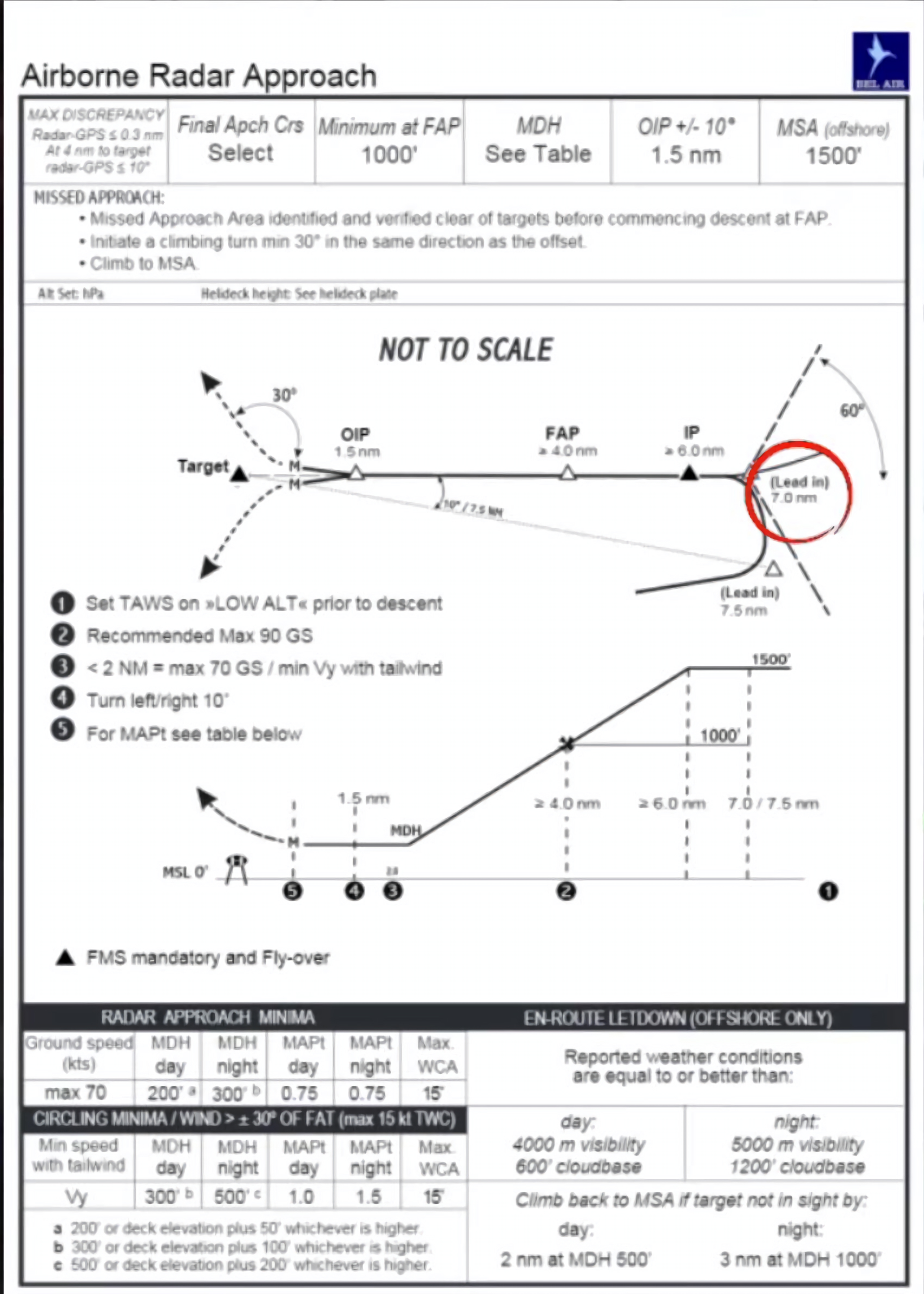
ARA procedures have been used by helicopter pilots flying to oil rigs since the early 1980s. They are based on the use of weather radar, which observes the reflection of oil rigs.
Firstly, the final approach track must be identified, and it must be placed against the wind direction.
The approach must be flown with the weather radar in mapping mode to identify an area clear of obstacles.
The approach is flown directly to the helideck. The missed approach point is located 0.75NM from landing, and the missed approach track is deflected by 10° off approach track.
Example ARA
Modern Offshore Approach Procedures
Advancements beyond the ARA have been made to enhance safety. The CAA has developed the SBAS Offshore Approach procedure (SOAP), and the FAA has developed the Offshore Standard Approach Procedure (OSAP).
The procedures still require the use of airborne weather radar to identify obstacles, but aditional safety is provided through the use of SBAS for accurate GPS positioning and lateral offset, as well as more precise horizontal and vertical guidance.
SOAP
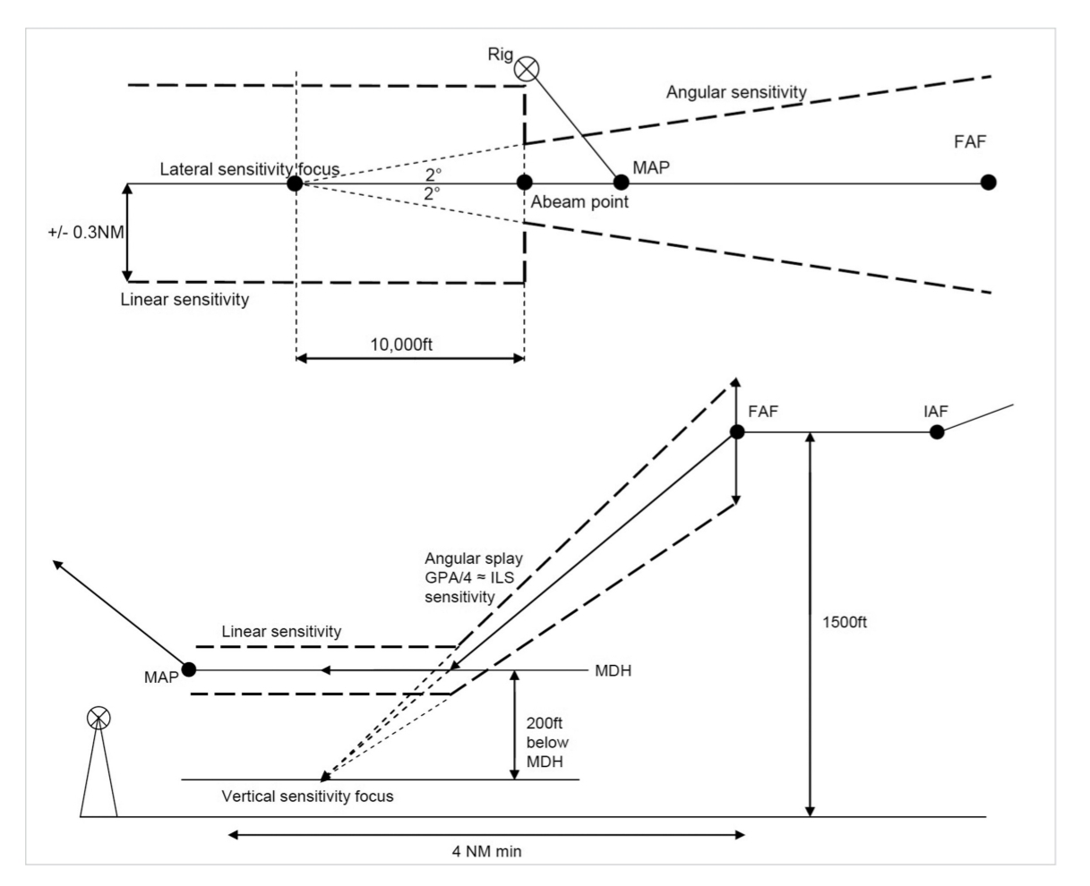
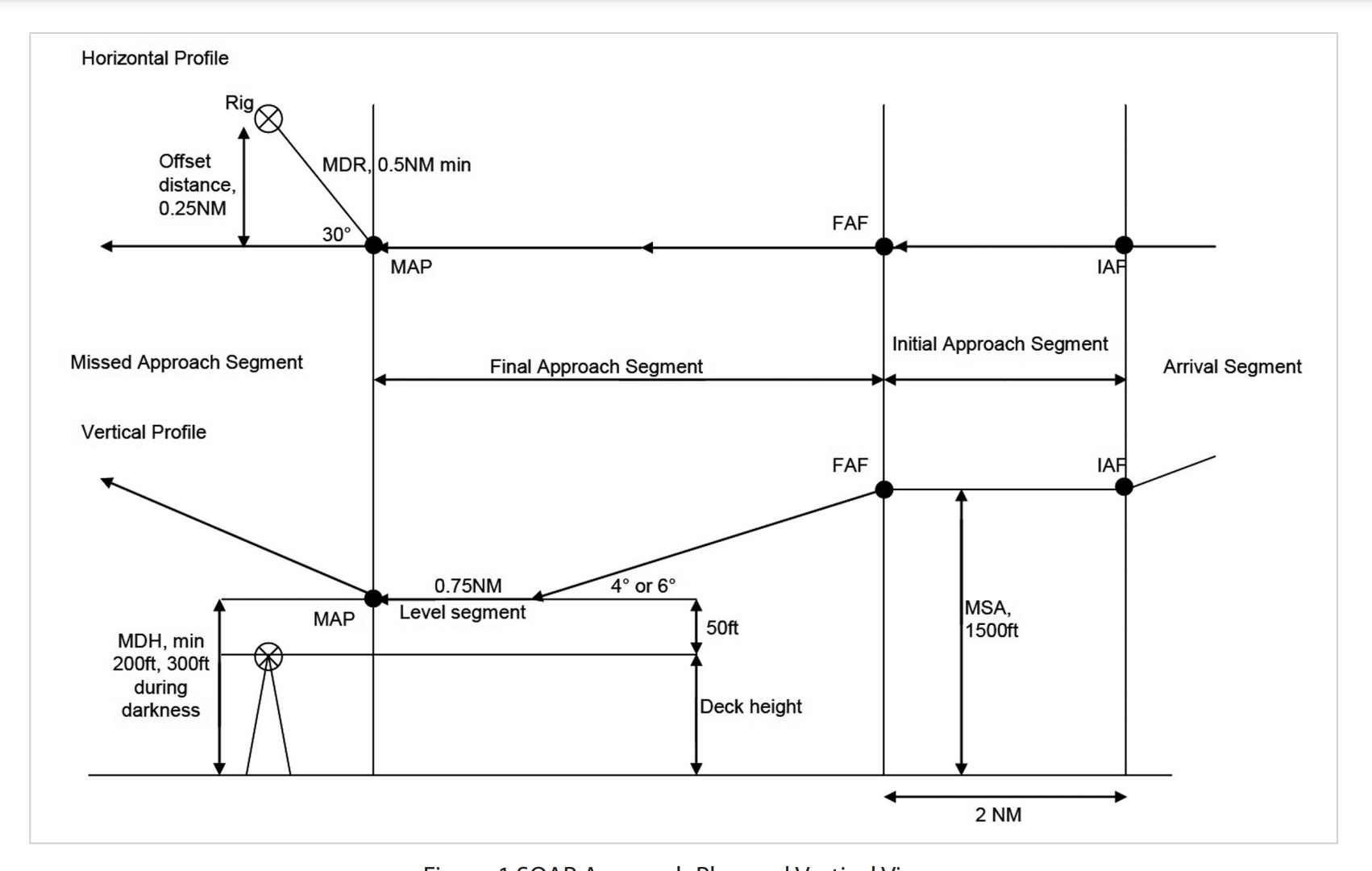
A typical SOAP consists of two segments between the FAF and MAPt: the descending segment and level segment. The length of descending segment depends on the angle of descent and on the MDH (Minimum Descent Height), where the MDH is defined as the height of helideck increased by 50ft and meeting the minimum 200ft during the day and 300ft overnight, according to the radar altimeter.
After reaching MDH, the helicopter goes into horizontal flight and the mission of flight crew is to establish visual contact with the landing site.
The MAPt is defined as the closest point to the landing site from which it is still possible to land safely. The minimum distance is 0.5NM at GS 60kts and maximum angle between the track and the direction towards the landing site is 30°. The length of the level segment is always 0.75NM to ensure sufficient time to get the visual contact. The guidance provided to pilots is shown in Figure 2.
SOAP Approach Plan and Vertical Views
Guidance Provided to the Pilots