BGSF | Kangarlussuaq
Local operating procedures for BGSF.
General
The largest airport in Greenland, Kangarlussuaq Airport (BGSF), also known as Sondrestrom, serves a critical role in Greenland air traffic. While the expansion of Nuuk International Airport (BGGH) has made that airport the main international and domestic hub of Greenland, BGSF still serves as a critical diversion point and cargo hub. BGSF is also still the only controlled airport in Greenland.
|
Runway |
RWY Dimensions (m) |
Heading |
|
09 |
2810x60 |
089 |
|
27 |
2810x60 |
269 |
List of ATS Positions
|
Coordination Name |
VATSIM Logon |
Radio Callsign |
Frequency |
|
Sondrestrom Tower (SFT) |
BGSF_TWR |
“Sondrestrom Tower" |
118.300 |
|
Sondrestrom Approach (SFA) |
BGSF_APP |
“Sondrestrom Approach" |
126.200 |
Login Priority
All positions may be opened at any time.
Sondrestrom TWR
Sondrestrom Tower (BGSF_TWR) provides clearance delivery, ground, and tower control.
Delivery
NOTE: Typically, the preferred runway configuration is RWY 09 for arrivals / RWY 27 for departures. See "Runway Configuration" below for more details.
Overview of SIDs
|
TERMINATING FIX |
RUNWAY |
|
|
09 |
27 |
|
|
BAVKO |
1A |
1B |
|
GILPO |
1A |
1B |
|
INPOD |
1A |
– |
|
ISTEC |
1A |
1B |
|
KEMOS |
1A |
1B |
|
WUTAN |
1A |
1B |
|
Initial Climb FL190 for Eastbound flights (TRK 000-179) FL180 for Westbound flights (TRK 180-359) (or RFL if lower) |
||
Clearance Procedure
All BGSF departures shall be given the latest weather (met report) with their IFR clearance. E.g.,
🎧 GRL418, ready to copy clearance and the weather?
🧑✈️ Ready to copy, GRL418.
🎧 GRL418, cleared to Keflavik via the WUTAN 1A departure, climb via SID FL190, Mach .80, squawk 3126.
🧑✈️ Cleared to Keflavik via the WUTAN 1A departure, climb via SID FL190, squawk 3126.
🎧 GRL418, readback correct. Kangarlussuaq met report at time 50, automatic, winds 060 degrees 9 knots, visibility 10 kilometers or more, no directional variation, clouds broken at 21000ft, temperature plus one, dewpoint minus four, QNH 1014.
🧑✈️ QNH 1014, GRL418.
🎧 GRL418, readback correct.
RWY 27 Departure Procedure (Non-RNAV)
This is necessary to avoid high terrain near the airport. 5300ft is the MSA (Minimum Safe Altitude) within 25 NM of BGSF.
The same initial climb applies as for the SIDs (FL190 for Eastbound departures / FL180 for Westbound, or RFL if lower.)
Ground
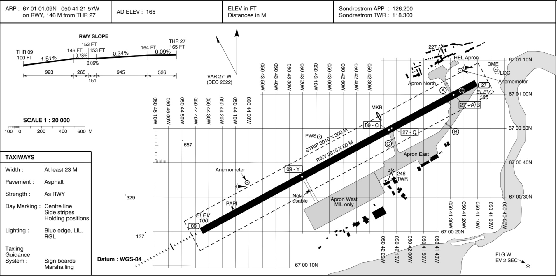
There are three main parking locations at BGSF:
- The North Apron is for scheduled passenger flights.
- The East Apron is for cargo and general aviation.
- The West Apron is for military operations.
Otherwise, BGSF has a fairly simple ground layout. The most important thing to note is that in the usual runway configuration (RWY 09 arrivals / RWY 27 departures), if an arrival requires full length for landing, it would likely vacate the runway from the same taxiways as departing aircraft would be holding short at. Controllers may consider instructing arrivals to make a 180 and backtrack to vacate, in order to avoid coming face-to-face with departing aircraft.
Tower
Runway Configuration
Due to high terrain near the airport, RWY 09 is the preferred arrival runway and RWY 27 is the preferred departure runway. Therefore, if the tailwind component for both runways is less than 10 KTS, TWR shall designate RWY 09 as the arrival runway and RWY 27 as the departure runway.
In this configuration, departures will depart into the arrival path. Typically this is not an issue due to BGSF’s low traffic levels, but TWR must coordinate with APP to ensure that large enough gaps are left in the arrival stream for aircraft to depart between arrivals.
When the tailwind component exceeds 10 KTS for either RWY 09 or RWY 27, TWR shall revise the runway configuration to depart & arrive on whichever runway has the strongest headwind component. The only exception is if conditions are IMC and/or if the ceiling is lower than 2200ft, in which case RWY 27 must be used for departure.
In periods of heavy traffic (assuming visibility is sufficient), TWR may also revise the runway configuration to use the same runway for departure/arrival, if it is expected that using opposite runways for departure and arrival would cause significant delays.
Sondre Stromfjord Control Zone (BGSF CTR)
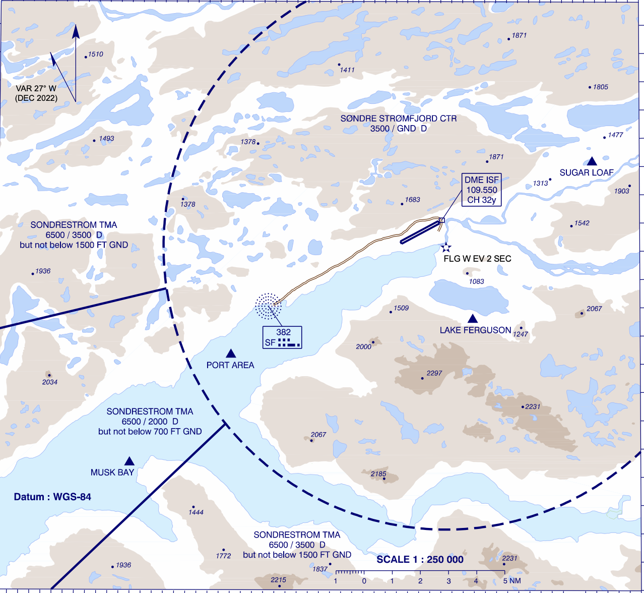
Note: the northeastern-most area of the BGSF CTR is cut off in the above image.
The Sondre Stromfjord Control Zone (BGSF CTR) surrounds BGSF from GND – 3500ft.
There are three visual reporting points which aircraft may follow while entering/exiting the CTR – Port Area, Musk Bay, and Sugar Loaf.
Due to surrounding high terrain, a left hand traffic pattern is preferred for RWY 27, and a right hand traffic pattern is preferred for RWY 09.
Missed Approaches
TWR shall instruct aircraft to follow the standard missed approach, and coordinate all missed approaches with APP prior to transferring to APP.
For aircraft unable the standard missed approach, TWR should instruct them to perform a visual climb and caution them of high terrain. The MSA within 25 NM of BGSF is 5300ft.
Sondrestrom APP
Sondrestrom Approach (BGSF_APP) provides an approach control service within the Sondrestrom TMA and CTA.
Sondrestrom TMA & CTA
The Sondrestrom TMA and CTA together make up the airspace controlled by Sondrestrom Approach.
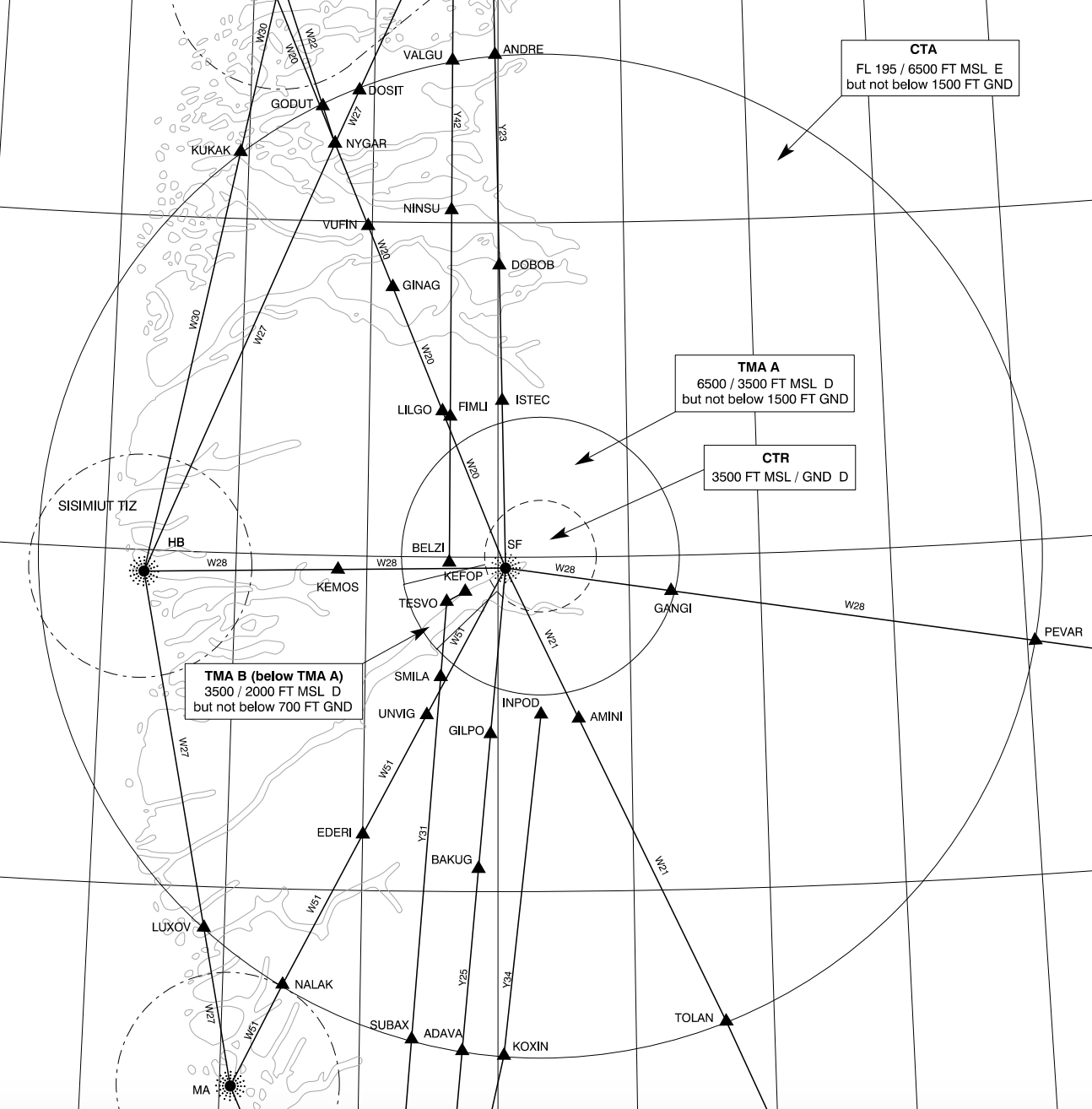
The CTA and TMA are arranged as three sections of cylindrical airspace.
- The CTA (6500ft – FL195) is the largest cylinder of airspace.
- TMA A (3500 – 6500ft), the main portion of the TMA, forms a smaller cylinder beneath the CTA.
- TMA B (2000 – 3500ft) is a small cylindrical segment, extending the TMA downwards to encompass the RWY 09 approach path. It directly underlies TMA A.
Arrivals
There are no STARs into BGSF. Aircraft generally join the instrument approach procedures directly from their flight plan route.
Runway 09
The RNP approach for RWY 09 is the preferred approach type. Aircraft should be cleared to either of the IAFs (DODIP or BELZI) and descended to the initial approach altitudes as published:
- DODIP: 5200ft
- BELZI: 4900ft
Missed Approach
TWR shall instruct aircraft to follow the standard missed approach. The standard missed approach varies between approaches:
- RNP: Climb runway track, passing 2500ft left turn direct SFT09, then direct KEFOP, climbing to 4000ft.
- LOC Z/Y: Climb on LOC course until the marker, then turn right track 103, passing 4000ft direct SF NDB, climbing to 4400ft.
- NDB Z/Y: At D2.5 ISF climb to 3000ft on track 097, then turn right direct SF NDB, climbing to 4400ft.
- RNP A/B (RWY 27): Climb on course 274, passing 3000ft direct KEFOP, climbing to 4000ft.
Strict adherence to the standard missed approaches is critical due to high terrain surrounding the airport.
TWR shall instruct aircraft unable the standard missed approach to perform a visual climb.
TWR shall coordinate all missed approaches with APP prior to transferring back to APP.
Non-Standard Approaches (RWY 09)
If aircraft are unable to accept the RNP approach, then alternative approaches should be offered in order of precision.
LOC Z/Y
There are two published localizer approaches – LOC Z (for category A and B aircraft) and LOC Y (for category C and D aircraft.) They are both teardrop procedures, starting from SF NDB and making a left turn inbound for the localizer.
As both procedures descend into the BGSF CTR, APP should coordinate with TWR to make them aware if the approaches are used.
NDB Z/Y
There are, similarly two NDB approaches – NDB Z (for category A and B) and NDB Y (for category C and D.) They are also teardrop procedures, except instead of using the localizer, aircraft fly a final approach course towards SF NDB and the runway.
As both procedures descend into the BGSF CTR, APP should coordinate with TWR to make them aware if the approaches are used.
Runway 27
While not officially published for RWY 27, there are two RNP approaches available which lead aircraft to RWY 27. (RNP A for categories A and B, and RNP B for categories C and D.)
Aircraft should be cleared to one of the three IAFs (RUMAQ, FICWE, or KEFOP) and descended to the initial approach altitudes as published:
- RUMAQ: 4000ft
- FICWE: 5000ft
- RIVOP: 4700ft
Alternatively, aircraft may perform a visual approach.
Circle-to-land is not permitted north of the aerodrome.
Departures
Aircraft shall follow either their SID, or the non-RNAV RWY 27 departure procedure of climbing on runway track, then when passing 5300ft, proceeding direct to join their flight planned route.
Strict adherence to the SID is required below the MSA (5300ft) due to high terrain. After passing the MSA, APP may issue a direct to the end of the SID, traffic permitting.