| **Runway** | **RWY Dimensions (m)** | **Heading** |
| 09 | 2810x60 | 089 |
| 27 | 2810x60 | 269 |
| **Coordination Name** | **VATSIM Logon** | **Radio Callsign** | **Frequency** |
| Sondrestrom Tower (SFT) | BGSF\_TWR | “Sondrestrom Tower" | 118.300 |
| Sondrestrom Approach (SFA) | BGSF\_APP | “Sondrestrom Approach" | 126.200 |
**NOTE:** Typically, the preferred runway configuration is RWY 09 for arrivals / RWY 27 for departures. See "Runway Configuration" below for more details.
### Overview of SIDs| **TERMINATING FIX** | **RUNWAY** | |
| **09** | **27** | |
| **BAVKO** | 1A | 1B |
| **GILPO** | 1A | 1B |
| **INPOD** | 1A | – |
| **ISTEC** | 1A | 1B |
| **KEMOS** | 1A | 1B |
| **WUTAN** | 1A | 1B |
| **Initial Climb** **FL190** for Eastbound flights (TRK 000-179) **FL180** for Westbound flights (TRK 180-359) *(or RFL if lower)* | ||
In this configuration, **departures will depart into the arrival path.** Typically this is not an issue due to BGSF’s low traffic levels, but TWR must coordinate with APP to ensure that large enough gaps are left in the arrival stream for aircraft to depart between arrivals.
When the tailwind component exceeds 10 KTS for either RWY 09 or RWY 27, TWR shall revise the runway configuration to depart & arrive on whichever runway has the strongest headwind component. The only exception is if conditions are IMC and/or if the ceiling is lower than 2200ft, in which case **RWY 27 must be used for departure.** In periods of heavy traffic (assuming visibility is sufficient), TWR may also revise the runway configuration to use the same runway for departure/arrival, if it is expected that using opposite runways for departure and arrival would cause significant delays. ### Sondre Stromfjord Control Zone (BGSF CTR) [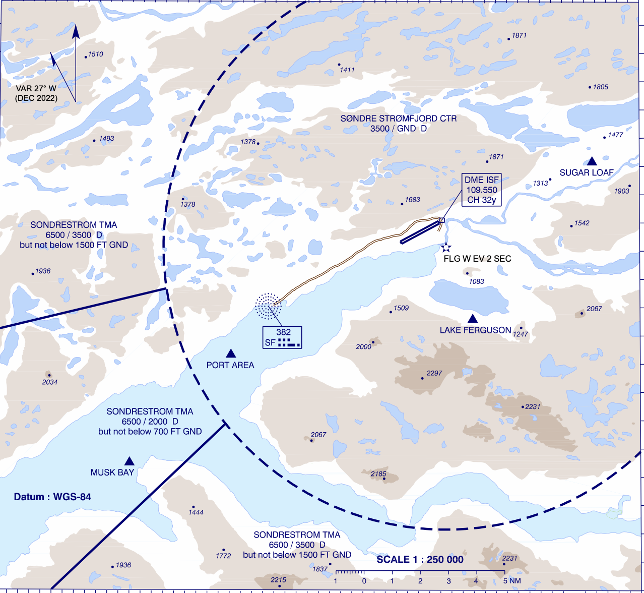](https://wiki.vatsim-scandinavia.org/uploads/images/gallery/2023-09/screenshot-2023-09-14-at-10-57-11-pm.png) *Note: the northeastern-most area of the BGSF CTR is cut off in the above image.* The Sondre Stromfjord Control Zone (BGSF CTR) surrounds BGSF from GND – 3500ft. There are three visual reporting points which aircraft may follow while entering/exiting the CTR – Port Area, Musk Bay, and Sugar Loaf. Due to surrounding high terrain, a **left** hand traffic pattern is preferred for RWY 27, and a **right** hand traffic pattern is preferred for RWY 09. ### Missed Approaches TWR shall instruct aircraft to follow the standard missed approach, and coordinate all missed approaches with APP prior to transferring to APP. For aircraft unable the standard missed approach, TWR should instruct them to perform a visual climb and caution them of high terrain. The MSA within 25 NM of BGSF is **5300ft.** # Sondrestrom APP **Sondrestrom Approach (BGSF\_APP)** provides an approach control service within the Sondrestrom TMA and CTA. ## Sondrestrom TMA & CTA The Sondrestrom TMA and CTA together make up the airspace controlled by Sondrestrom Approach. [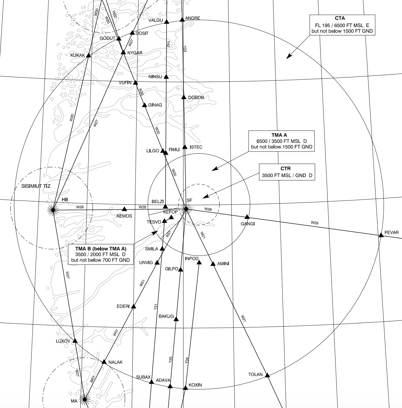](https://wiki.vatsim-scandinavia.org/uploads/images/gallery/2023-09/screenshot-2023-09-14-at-11-03-39-pm.png) The CTA and TMA are arranged as three sections of cylindrical airspace. - The **CTA** (6500ft – FL195) is the largest cylinder of airspace. - **TMA A** (3500 – 6500ft), the main portion of the TMA, forms a smaller cylinder beneath the CTA. - **TMA B** (2000 – 3500ft) is a small cylindrical segment, extending the TMA downwards to encompass the RWY 09 approach path. It directly underlies TMA A. ## Arrivals There are no STARs into BGSF. Aircraft generally join the instrument approach procedures directly from their flight plan route. ### Runway 09 The RNP approach for RWY 09 is the preferred approach type. Aircraft should be cleared to either of the IAFs (DODIP or BELZI) and descended to the initial approach altitudes as published: - **DODIP:** 5200ft - **BELZI:** 4900ft ### Missed Approach TWR shall instruct aircraft to follow the standard missed approach. The standard missed approach varies between approaches: - **RNP:** Climb runway track, passing 2500ft left turn direct SFT09, then direct KEFOP, climbing to 4000ft. - **LOC Z/Y:** Climb on LOC course until the marker, then turn right track 103, passing 4000ft direct SF NDB, climbing to 4400ft. - **NDB Z/Y:** At D2.5 ISF climb to 3000ft on track 097, then turn right direct SF NDB, climbing to 4400ft. - **RNP A/B (RWY 27):** Climb on course 274, passing 3000ft direct KEFOP, climbing to 4000ft. Strict adherence to the standard missed approaches is critical due to high terrain surrounding the airport. TWR shall instruct aircraft unable the standard missed approach to perform a visual climb. TWR shall coordinate all missed approaches with APP prior to transferring back to APP. ### Non-Standard Approaches (RWY 09) If aircraft are unable to accept the RNP approach, then alternative approaches should be offered in order of precision. #### LOC Z/Y There are two published localizer approaches – LOC Z (for category A and B aircraft) and LOC Y (for category C and D aircraft.) They are both teardrop procedures, starting from SF NDB and making a left turn inbound for the localizer. As both procedures descend into the BGSF CTR, APP should coordinate with TWR to make them aware if the approaches are used. #### NDB Z/Y There are, similarly two NDB approaches – NDB Z (for category A and B) and NDB Y (for category C and D.) They are also teardrop procedures, except instead of using the localizer, aircraft fly a final approach course towards SF NDB and the runway. As both procedures descend into the BGSF CTR, APP should coordinate with TWR to make them aware if the approaches are used. ### Runway 27 While not officially published for RWY 27, there are two RNP approaches available which lead aircraft to RWY 27. (RNP A for categories A and B, and RNP B for categories C and D.) Aircraft should be cleared to one of the three IAFs (RUMAQ, FICWE, or KEFOP) and descended to the initial approach altitudes as published: - **RUMAQ:** 4000ft - **FICWE:** 5000ft - **RIVOP:** 4700ft Alternatively, aircraft may perform a visual approach.Circle-to-land is **not permitted** north of the aerodrome.
## Departures Aircraft shall follow either their SID, or the non-RNAV RWY 27 departure procedure of climbing on runway track, then when passing 5300ft, proceeding direct to join their flight planned route. Strict adherence to the SID is required below the MSA (5300ft) due to high terrain. After passing the MSA, APP may issue a direct to the end of the SID, traffic permitting.