# ESPE - Vidsel
### Overview
Vidsel air base is a military airport located 15 km west-northwest of the village of Vidsel. It is a critical part of Vidsel Test Range that provides an aerospace test and evaluation asset for Sweden through the Test & Evaluation (T&E) department of Swedish Defence Materiel Administration (FMV).
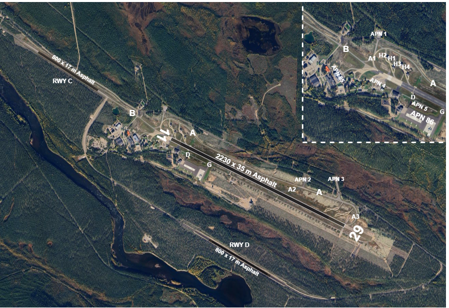
The base has one main runway (RWY 11/29, 2230 m length) and three auxiliary runways (known as "short" runways, which are 800 m long), of which two (RWY C and RWY D) are operational.
#### [**Airport Charts**](https://chartfox.org/ESPE)
#### AD Chart
### Parking stands
#### **Aprons**
- APN 1-5 available for fast jets and smaller aircraft
- APN 86 for transport aircraft
- H1-H4 next to THR 11 for fast jets
### Taxi
C130 not allowed to taxi between main RWY and short RWY C.
### Take-off and climb
Contact Vidsel Approach when instructed by TWR.
On initial contact with Vidsel Approach report altitude to verify transponder Mode C readout.
### MET information
As there is no ATIS, expect ATC to read the relevant weather information for arrival and departure.
### Military traffic
#### Regulations
Military pilots should be familiar with **[Rules and Procedures for Military Aviation](https://wiki.vatsim-scandinavia.org/books/gop/page/rules-and-procedures-for-military-aviation)**.
#### COM Channels
| Login Callsign |
Radio Callsign |
Frequency |
MIL Channel |
| ESPE_APP |
Vidsel Approach |
124.150 |
C2 |
| ESPE_F_APP |
Vidsel Approach |
119.200 |
C |
| ESPE_P_APP |
Vidsel Precision |
135.400 |
B |
| ESPE_TWR |
Vidsel Tower |
130.400 |
A |
Expect the MIL channel designation to be used when getting a frequency change, for example:
CONTACT VIDSEL APPROACH CHANNEL CHARLIE TWO.
#### Instrument approach procedures
No civil instrument approach procedures published.
- **RWY 29:** ILS/LOC, MILS, TILS, PAR, SRE, VDF
- **RWY 11**: SRE
**MIL instrument approach procedures**
RWY 11
- Initial approach altitude 2900 ft
- Safety altitude:
- SRE **1650** ft
- MAP: straight ahead
RWY 29
- Initial approach altitude 2600 ft
- Safety altitude:
- MILS 794 ft
- TILS 830 ft
- PAR **900** ft
- SRE **1200** ft
- VDF **1820** ft
- MAP: straight ahead to 3200 ft