General Briefing
Introduction
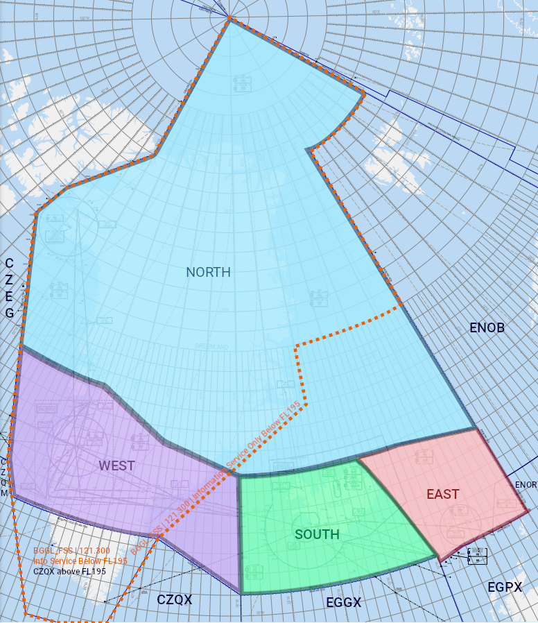
The Reykjavik Control Area (BIRD CTA) covers over 5.4 million square kilometres of oceanic airspace between North America and Europe, stretching all the way to the North Pole. Under this airspace lie three territories: Iceland, Greenland and the Faroe Islands, each with unique geography, airports, and airspace. Together, they offer the VATSIM pilot limitless opportunities for flying.
Our closest territorial neighbors are Norway, Canada, and Scotland. Neighboring FIRs and oceanic areas include Murmansk (ULMM), Bodo Oceanic (ENOB), Polaris (ENOR, specifically Stavanger/ENSV AoR), Scottish (EGPX/SCO), Shanwick (EGGX), Gander (domestic & oceanic; CZQX/CZQO), and Edmonton (CZEG.)
Reykjavik CTA Sectors & Positions
The BIRD CTA is split into four sectors: North, South, East, and West.
If in doubt about who to contact, check vatglasses.uk, ask the controller via private message (if they are not busy), or wait for a .contactme from the correct controller. The following text is provided for reference, in case pilots want to plan ahead who they may be speaking to.
(Note: VATGlasses, while accurate on an everyday basis, may not be fully accurate during big events like CTP, because the "standard" sectorization system of BIRD may be changed for the event. In such situation, just contact whoever your previous ATC position told you to contact — that controller will have the most up-to-date information.)
The most commonly staffed BIRD_x_CTR position is BIRD_S1_CTR (frequency 119.700.) This position, when online by itself, covers the West, South, and East sectors, and provides top-down coverage for all of Iceland, the Faroe Islands, and Kangerlussuaq (BGSF) in central Greenland.
There are, of course, various other BIRD positions available to be opened. Every BIRD position will follow a standard callsign convention: BIRD_xy_CTR
- BIRD — The airspace identifier for the BIRD CTA.
- "x" will be a letter (S, E, or W), indicating which sector the controller is covering (South, East, or West.)
- All BIRD_Sx_CTR (South sector) positions will also cover the East & West sectors when no East/West sectors are online.
- "y" will be a number from 1-3. Pilots do not need to worry about what these numbers mean — they are used for internal purposes by ATC to determine what vertical airspace each controller will cover.
- CTR is the normal VATSIM suffix for an enroute ATC position.
E.g., BIRD_S1_CTR, BIRD_S3_CTR, BIRD_W1_CTR, BIRD_E2_CTR...
You may have noticed that there is no BIRD logon callsign for the North sector. This is because the North sector is controlled exclusively by Iceland Radio (BICC_x_FSS.) Iceland Radio is a unique position on VATSIM, that for our purposes provides the following services:
- ATC in the North sector.
- Oceanic clearances for airborne aircraft entering the entire BIRD OCA.
- Oceanic/IFR clearances for departures on the ground at Greenlandic uncontrolled airports (usually relayed by local AFIS, but if no local AFIS is online, then pilots may contact BICC directly.)
- (If the BIRD West sector is not otherwise covered and workload permits) ATC service in the West sector.
- (If BGGL_FSS/Nuuk Information is offline and workload permits) Flight information service in Nuuk FIR below FL195.
- (If BGSF_TWR/APP are offline and workload permits) Top-down ATC at BGSF (Kangerlussuaq)
Oceanic Airspace
Much of the BIRD CTA — except some low-level airspace over Iceland and Greenland — is oceanic airspace, forming part of the North Altantic (NAT) oceanic area together with Gander/CZQO, Shanwick/EGGX, New York/KZNY, and Santa Maria/LPPO.
Even though the BIRD OCA is oceanic airspace, thanks to technological advancements, the entirety of the BIRD CTA/OCA now has either radar or ADS-B coverage at the enroute level. Therefore, position reports are not required, and pilots can expect that they will receive instructions (e.g., vectoring, directs, etc.) and be controlled similarly to a typical "domestic" ATC position.
The parts of the BIRD CTA which are oceanic airspace are referred to as the Reykjavik Oceanic Area (BIRD OCA.)
NAT Tracks
The North Atlantic oceanic airspace uses a system of organized tracks called the North Atlantic Organized Track System (NAT OTS) to regulate traffic crossing the ocean. While usually remaining in Shanwick & Gander OCAs, the tracks do occasionally enter the Reykjavik OCA.
The latest NAT tracks are published in the NAT Track Message. The most recent track message may be viewed at notams.faa.gov/common/nat.html. The NAT Track Message includes the following key information:
- The routing for each track
- The flight levels permitted for each track
- Aircraft on a NAT track may fly at any permited flight level published for that track. The usual East/West semi-circular rule (Eastbound flights at odd levels/Westbound flights at even levels) does not apply
E.g., the following excerpt from a track message:
U RIKAL 53/50 54/40 55/30 55/20 RESNO NETKI
EAST LVLS 340 350 360 370 380 390 400
WEST LVLS NIL
...means that track U has the routing "RIKAL 53N050W 54N040W 55N030W 55N020W RESNO NETKI," with valid Eastbound FLs of FL340, 350, 360, 370, 380, 390, and 400, and no valid Westbound FLs.
The NAT OTS changes direction twice daily, based on the prevailing flow of scheduled flights across the North Atlantic. Westbound tracks are valid from 1130-1900z, and Eastbound tracks are valid from 0100-0800z.
- For VATSIM purposes, since the real-life flow of traffic is not relevant (virtual pilots fly both directions across the North Atlantic at all times of day), it is generally acceptable to fly an “expired” track outside of its validity hours, if the latest tracks going the opposite direction have not yet come into effect.
- E.g., A Westbound flight entering oceanic airspace at 2000z may use the most recent Westbound tracks that expired at 1900z, since the next set of tracks has not been published yet.
- However, a Westbound flight entering oceanic airspace at 0200z may not use the recently expired Westbound tracks, since the next set of Eastbound tracks are already in effect. Such a flight must file a random routing (i.e., not on a NAT track.)
The tracks are named alphabetically based on their northerliness. E.g., Track A is the northernmost track, then Track B, etc.
The NAT Track Message also contains a Track Message Identification (TMI) number, which helps operators & ATC verify that all flights are using the correct tracks & routings. The TMI number is the current Julian calendar date (i.e., how many days there have been in the year so far.)
- E.g., the 16th of January would have a TMI of 016, and the 5th of March would have a TMI of 064.
- If the NAT track message has to be re-issued for any reason (e.g., correcting an error), then a letter will be added at the end of the TMI (e.g., 064A, 064B, etc.)
Entering Oceanic Airspace
As of 20th March 2024, it is no longer required to obtain an oceanic clearance (OCL) to fly within the BIRD OCA. IFR flights departing Iceland, Greenland, or the Faroe Islands will receive a standard IFR clearance.
If you are:
- Already airborne,
- Entering Reykjavik OCA, and,
- Have not previously spoken to any other oceanic ATC (Gander, Shanwick, etc.)
You need to contact Iceland Radio (if online) or Reykjavik Control before entering oceanic airspace, and provide the following information:
- Oceanic Entry Point (OEP) – i.e., your first waypoint in oceanic airspace
- ETA for the OEP
- Mach Number
- Requested Flight Level – i.e., intended flight level at oceanic entry
- The highest acceptable (maximum) Flight Level which you can attain at the OEP
Even though there are no more "oceanic clearances," the above is still called a "request for clearance" (RCL) message (yes, it is rather confusing...)
At the moment, you must use voice to transmit your RCL message to Reykjavik Control. The Nattrak website has not been updated yet. If you have previously received ATC service from any other oceanic sector, e.g., Gander, Shanwick, etc., you do not need to provide Reykjavik Control with a new RCL message.
Reykjavik Control may respond to your RCL message in one of two ways:
- "Fly current flight plan," which means follow your existing flight plan, as previously cleared & loaded into your FMS, with no changes.
- Issuing an amended clearance, which may include changes to your routing, flight level, or Mach speed
If you have previously received ATC service from any other oceanic sector, e.g., Gander, Shanwick, etc., you do not need to provide Reykjavik Control with a new RCL message.
Voice Phraseology
Example 1: Fly current flight plan (no changes to flight plan required)
🧑✈️ Reykjavik Control, ICE123, request for clearance.
🎧 ICE123, go ahead.
🧑✈️ ICE123, oceanic entry point is VALDI, estimating VALDI at 1234z, Mach .79, FL340, maximum flight level 360.
🎧 ICE123, roger, fly current flight plan.
🧑✈️ Fly current flight plan, ICE123.
Example 2: Amended clearance
If the aircraft's flight plan must be amended, instead of "fly current flight plan," Reykjavik Control will use the phrase "amended [speed/route/level] clearance," followed by the details of the amended clearance. E.g.,
🧑✈️ Reykjavik Control, ICE456, request for clearance.
🎧 ICE456, go ahead.
🧑✈️ ICE456, oceanic entry point is IPTON, estimating IPTON at 1235z, Mach .79, FL340, maximum flight level 360.
🎧 ICE456, amended route and speed clearance, after IPTON cleared direct ING, then direct NASBU, maintain Mach .76.
🧑✈️ After IPTON cleared direct ING then direct NASBU, maintain Mach .76, ICE456.
🎧 ICE456, readback correct.
ATC may also issue a conditional instruction (e.g., cross a waypoint, climb/descend to a level, etc.) "at," "at or before," or "at or after" a certain time, to ensure traffic separation. E.g.,
🎧 ICE456, cross IPTON at or after 1236z.
If you are flying via a NAT track, Reykjavik Control will also verify the current TMI number with you prior to oceanic entry, to make sure you are flying the correct tracks.


