Offshore Guide
Offshore Guide
Introduction
General
Cruising Altitudes
Civil helicopters operating to and from off-shore installations in the North Sea where air traffic services are provided by Norway, will outside controlled airspace be operating at following altitudes, based on area/forecast QNH minimum.
| Magnetic track | Altitude |
|---|---|
| 000 ̊ - 179 ̊ | 3000FT |
| 180 ̊ - 359 ̊ | 2000FT |
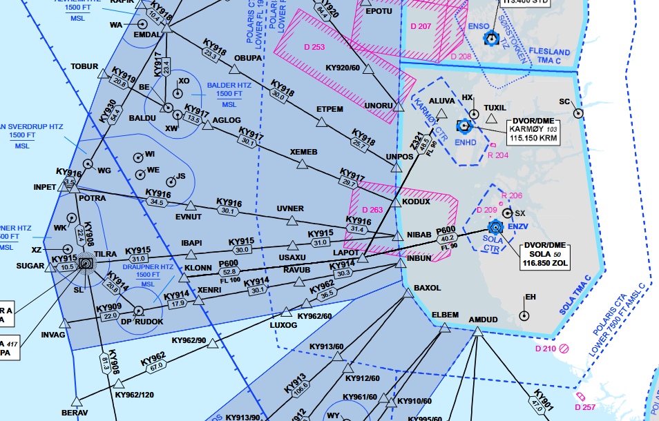
Helicopter Routes
Helicopter Routes (HR) are established in that part of the North Sea and Norwegian Sea where Norway is responsible for providing ATS (REF AIP Norway GEN 3.3).
A HR is an ATS-route frequently used by civil helicopters, along which control and flight information service may be provided. They can be directional or bi-directional.
Civil helicopters are normally operating within 4 NM either side of the HR from 1000 FT AMSL to FL 80.
The HR (KY tracks) shall be utilizied outside surveillance coverage. Within surveillance-coverage, flights may be routed on direct track by ATS.
Cruising below a CTA
Flights planned at 1000 FT shall follow a HR. If the flight is planning to follow a bidirectional HR (e.g KY916), this procedure shall be used:
| Magnetic track | Altitude |
|---|---|
| 360 ̊ - 179 ̊ | 1000FT |
| 180 ̊ - 359 ̊ | 2000FT or above* |
Altimeter setting
Within Polaris FIR south of 66.20 ̊N, altimeter setting at 7000 FT or lower is based on actual area QNH.
- ATS will provide QNH for the QNH Areas.
- A change to a new QNH shall be carried out when instructed by ATS.
- Transition Level for a CTA will be determined based on the lowest observed area QNH inside the CTA.
- Transiton Altitude is 7000FT
Within Polaris FIR north of 66.20 ̊N, altimeter setting is based on Forecasted Minimum QNH within Altimeter Setting Regions (ASR) Bjornoya.
- An estimate of the lowest QNH value for a longer period will be made for the Altimeter Setting Region and is available from ATS provider or MET office.
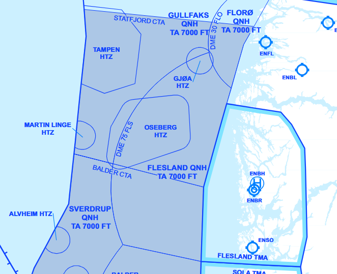
ADS areas
ADS areas are defined areas of Class G airspace, either below a CTA (MSL – 1500 FT), or a specific area (MSL – FL 085) between the main land bases and the main oilfields where radar- and/or ADS-based ATS is provided to ADS equipped helicopters.
Communication
Air Traffic Service
Air traffic service provided for helicopter operations on the Norwegian continental shelf:
Southern Norway
| Area | Service | Provided by |
|---|---|---|
| Statfjord CTA | Air Traffic Control | Polaris ACC Stavanger |
| Balder CTA | ||
| Ekofisk CTA | ||
| Statfjord ADS | Flight Information | |
| Balder ADS | ||
| Balder ADS | ||
| Tampen HTZ | Tampen HFIS | |
| Ekofisk HTZ | Ekofisk HFIS | |
| HTZ | Polaris ACC Stavanger |
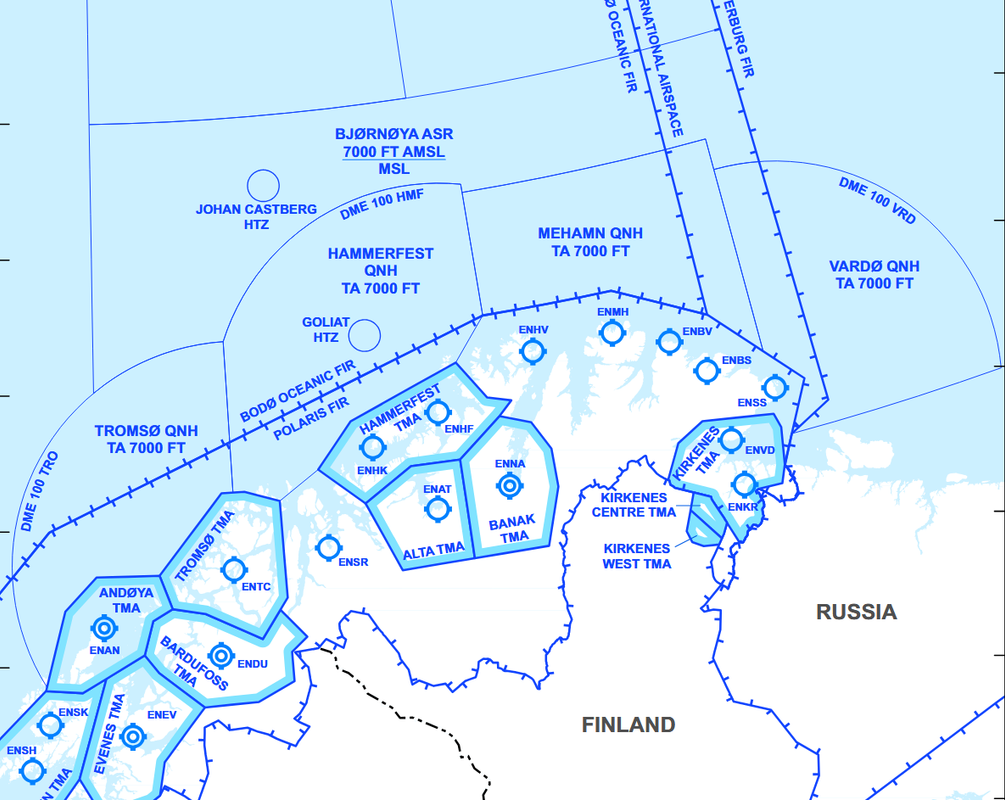
Middle and Northern Norway
| Area | Service | Provided by |
|---|---|---|
| Heidrun CTA | Air Traffic Control | Polaris ACC Bodø |
| Heidrun ADS | Flight Information | |
| Norne ADS | ||
| Barents Sea | ||
| HTZ |
Radio communication
On-deck report
After landing on an installation, pilots shall deliver an on-deck report to the appropriate ATS unit, and shall contain:
- Callsign
- Name on the installation
- Actual time of arrival (ATA)
- Additional information if required (e.g. refueling, shut down)
NOR123 on deck, Gullfaks C, 1450
Pre-lift-off report
Prior to lift-off from any installation, pilots shall deliver a pre-lift-off report to the appropriate ATS unit, and shall contain:
- Callsign
- Location
- Intended route
- Intended altitude or level
The appropriate ATS unit shall provide traffic information before lift-off is initiated.
NOR123 ready for lift, Gullfaks C, flight planned route to Flesland, 3000ft.
NOR123, ready for lift, Gullfaks C to Martin Linge via NEBAV direct NASET, 2000ft.