Norway Offshore Guide
Introduction
Norway sees a lot of offshore helicopter traffic related to the oil and gas industry. Civil helicopters operate from onshore bases (ENHF, ENBN, ENKB, ENFL, ENBR and ENZV) to, from and between fixed and moveable installations on the Norwegian Continental Shelf. These operators also fly SAR flights on contracts from the norwegian government.
Offshore helicopter procedures are somewhat specialized and tailored to the risks and challenges involved with flying far out over the seas in harsh enviroments. This guide is intended as a simplified summary of the unique helicopter procedures, flight planning considerations and radiotelephony used in offshore flying, for both pilots and ATC.
Sources: Avinor Helicopter Manual, AIP Norway, EASA EAR for Air OPS, FAA AC 90-80C
General
Flightplan requirements
When applicable, this must be indicated in the flightplan by adding B1 or B2 to the transponder equipment code.
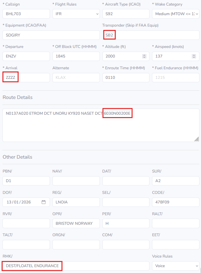
Flight plans to sea vessels/temporary installations not given a ENxx identifier, shall have ZZZZ as destination, coordinates of the vessel at the end of the route, and DEST/NAME OF VESSEL added to the remark field.
Example flight plan
Free Routes
Helicopters with operative ADS-B transponder can normally file from SID-endpoint DCT destination, DCT between installations offshore or from offshore installations DCT STAR start point or IAF (see Note for ENBR arrivals).
Helicopter routes are described below. They must be used when a/c does not have a functioning ADS-B transponder (when exemption is given from either NCAA or from the ATS unit for single flights) or when ATM service is downgraded (due reduced COM/SUR etc).
Note: Arrivals to ENBR: Helicopter STARs are dependent on Runway in use at ENBR. FPLs shall be filed DCT TMA boundary fix. Expect routing/clearance direct STAR start point for Runway in use when traffic permits.
Helicopter Routes
Helicopter Routes (HR) are established in the parts of the North Sea, Norwegian Sea and the Barents Sea where Norway is responsible for providing ATS (REF AIP Norway GEN 3.3).
A HR is an ATS-route frequently used by civil helicopters, along which control and flight information service may be provided. They can be directional or bi-directional.
Civil helicopters will normally operate direct destinations from 500 FT AMSL to FL 80, but will follow an HR if the situation requires so.
Example of helicopter routes in South Norway
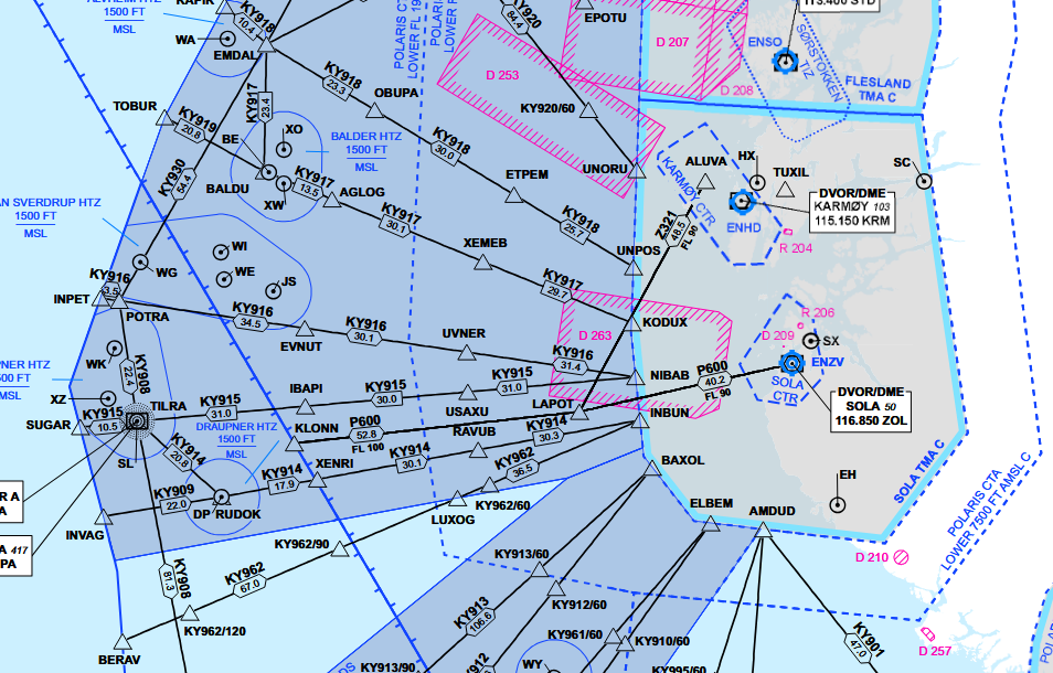 Ref. AIP ENR 6-23 | Offshore Helicopter Area - Southern Norway
Cruising Altitudes
Civil helicopters operating to and from offshore installations will normally be operating at the following altitudes, based on actual QNH/forecast minimum:
| Magnetic track | Altitude |
|---|---|
| 000 ̊ - 179 ̊ | ODD levels 3000 FT or above |
| 180 ̊ - 359 ̊ | EVEN levels 2000 FT or above |
If weather conditions or other circumstances necessitate operations below 2000 FT, the following altitudes based on radar altimeter will normally be used.
| Magnetic track | Altitude |
|---|---|
| 000 ̊ - 179 ̊ | 1000FT |
| 180 ̊ - 359 ̊ | 500FT |
Altimeter setting
QNH setting areas are based on actual QNH. The exception is Bjørnøya ASR, where a forecast minimum QNH is used. A change to a new QNH shall be carried out when instructed by ATS, as this may have implications on separation from other aircraft.
Transition altitude is 7000 FT. For flights at 1000 FT or below, radar altimeter shall be used.
Example of QNH Areas in Southwest Norway
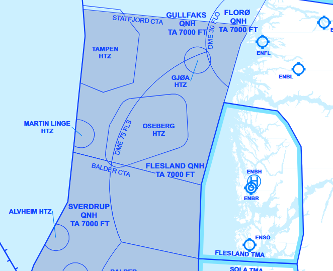 Ref. AIP ENR 6-30 | QNH Setting Areas - Southwest Norway
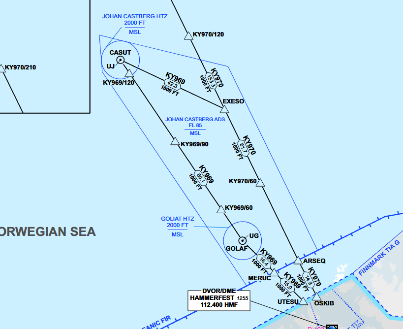
Example of QNH Areas and Altimiter Setting Regions in North Norway
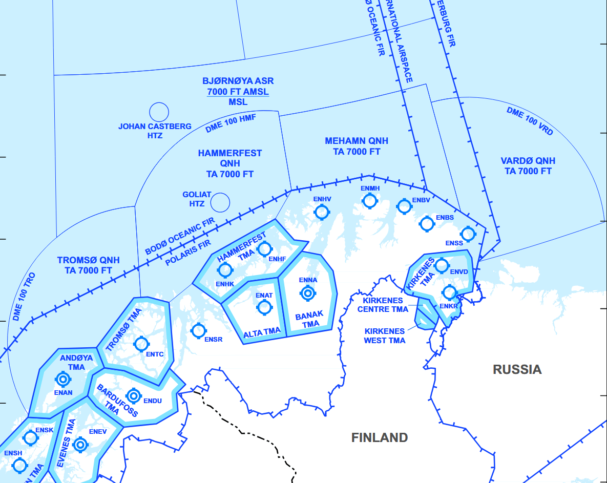 Ref. AIP ENR 6-32 | QNH Setting Areas - Barents
ADS areas
ADS areas are defined areas of Class G airspace, either below a CTA (MSL – 1500 FT), or a specific area (MSL – FL 085) between the main land bases and the main oilfields where surveillance based ATS is provided to participating helicopters.
Example of ADS Area without CTA
 Ref. AIP ENR 6-25 | Offshore Helicopter Area - Northern Norway
Control Areas (CTA)
Defined Control Areas are established on the Norwegian continental shelf with Class-D Airspace, from 1500 FT- FL085. Heidrun CTA is established in the Norwegian Sea. Statfjord CTA, Balder CTA and Ekofisk CTA are established in the North Sea.
Example of CTA with ADS Area below
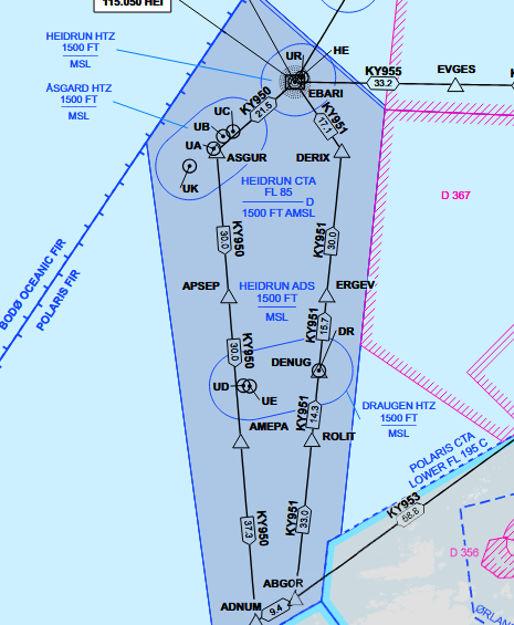
Ref. AIP ENR 6-24 | Offshore Helicopter Area - Southern part of Mid-Norway
Helicopter Traffic Zones (HTZ)
A HTZ is established at all permanent offshore installations on the Norwegian continental shelf within a radius of 7 NM from the landing pad and comprises the airspace between MSL and 2000 FT, or to the lower limit of a CTA. Around groups of two or more installations, and with distance of less than 10 NM from each other, a common HTZ is established with the border tangential to a 7 NM radius from the landing pads.
Helicopter Traffic Zones are Radio Mandatory Zones (RMZ) and two-way radio contact must be established with the approriate ATS-facility before entry.
Example of Tampen HTZ
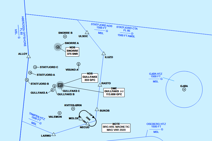 Ref. AIP ENR 6-27 | Helicopter Traffic Zone (HTZ) Part 2
Helicopter procedures
Onshore
IFR Procedures
Except some minor differences, instrument flying is very similar for both fixed and rotary wing aircraft. Rules followed by rotary and fixed wing pilots after take-off until final approach are almost the same.
The major differences come up with the operational concerns. For example, special take-off and landing minimums dedicated for helicopters allow them to take-off and land in lower visibility conditions.
If requested by ATC, helicopters are obliged to comply with every necessities stated in standard departure and approach procedures. However, if available to the pilot, helicopter specific procedures will normally be offered.
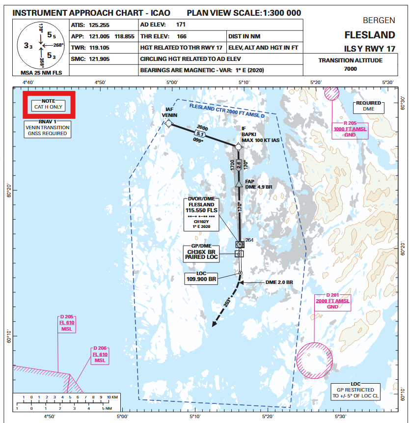
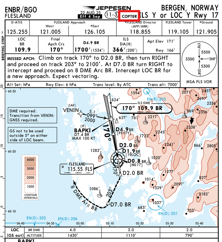
Example of Copter only apparoaches
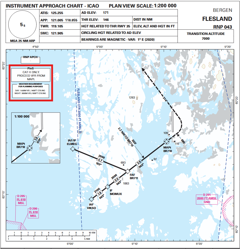
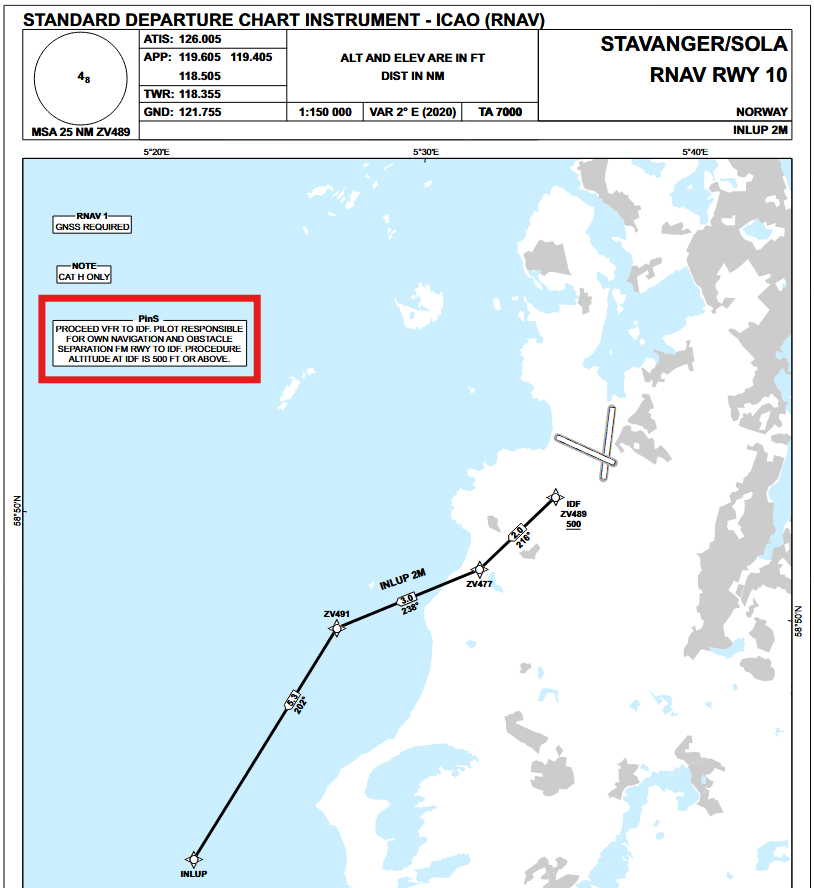
PinS - Point in Space
The Point-in-Space (PinS) concept is a flight operation based on GNSS and designed for helicopters only. It relies on the possibility for the pilot to conduct flight under IMC to/from a PinS (point in space) and not directly to/from the heliport.
PinS procedures are established as both approach and departure procedures in Norway.
Example of PinS procedures
Offshore
VFR Minimums
When using an offshore location as a destination or alternate, during the period between 1 hour before and 1 hour after expected time of arrival, weather forecasts should indicate above the following minima:
| Day | Night | |
|---|---|---|
| Cloud base | 600 ft | 800 ft |
| Visibility | 4 km | 5km |
When flying between offshore locations located in class G airspace where the overwater sector is less than 10 NM, VFR flights may be conducted when the limits are at, or better than, the following:
| Day | Night | |
|---|---|---|
| Height* | 300 ft | 500 ft |
| Visibility | 3 km | 5km |
*The cloud base shall allow flight at the specified height to be below and clear of cloud.
Offshore Enroute Let-down
The offshore enroute let-down procedure, also called cloud break, is a general means to transition from IMC to VMC during the enroute environment. According to minimum reported weather conditions, decent below offshore MSA (1500ft) can be commenced to given thresholds, followed by a visual approach or climb back to MSA.
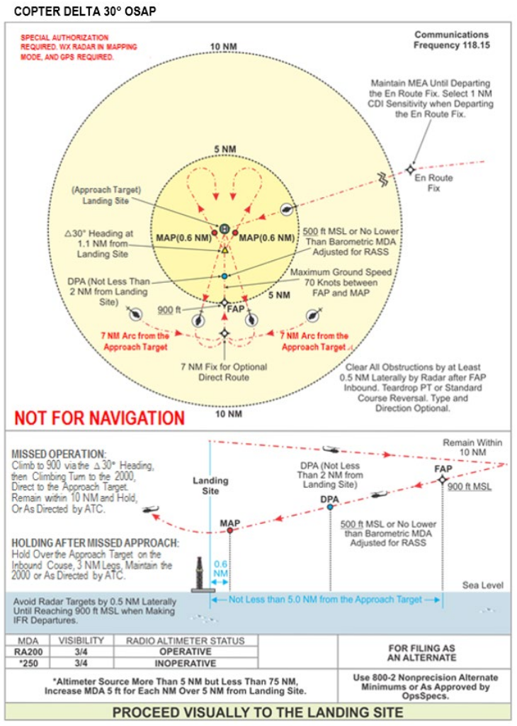
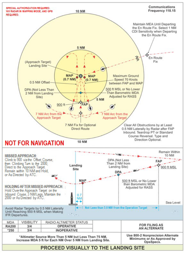
Offshore Standard Approach Procedure (OSAP)
OSAPs are non-precicion approach procedures specifically designed for offshore locations, aided with GNSS/SBAS and real-time obstacle awareness systems. There are multiple designs based on the visual segment.
The final approach track must be identified, and it must be placed against the wind direction.
Sample Delta 30° OSAP
Sample Paralell Offset OSAP
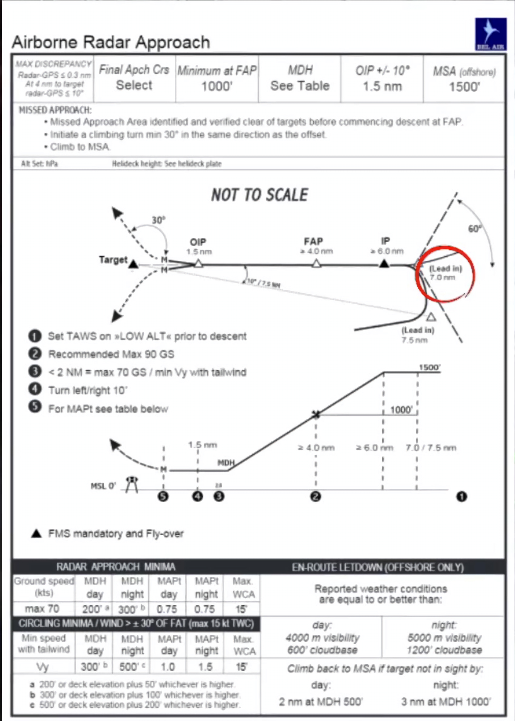
Airborne Radar Approach (ARA)
ARA procedures have been used by helicopter pilots flying to oil rigs since the early 1980s. They are based on the use of weather radar, which observes the reflection of oil rigs. ARA need not be based on GPS points, but only few offshore installations have radio navigation aids, making GPS the only way to identify the installation.
Sample ARA
METAR
Offshore platform METARs contain some additional parameters that are not found on shore.
- Sea surface temperature in degrees celsius = Wxx/Sxx
- State of the sea = Wxx/Sx
| WMO Sea state code | Wave height | Charasteristics |
|---|---|---|
| 0 | 0 metres (0 ft) | Calm (glassy) |
| 1 | 0 to 0.1 metres (0.0 to 3.9 in) | Calm (rippled) |
| 2 | 0.1 to 0.5 metres (3.9 in to 1 ft 7.7 in) | Smooth (wavelets) |
| 3 | 0.5 to 1.25 metres (1 ft 8 in to 4 ft 1 in) | Slight |
| 4 | 1.25 to 2.5 metres (4 ft 1 in to 8 ft 2 in) | Moderate |
| 5 | 2.5 to 4 metres (8 ft 2 in to 13 ft 1 in) | Rough |
| 6 | 4 to 6 metres (13 to 20 ft) | Very rough |
| 7 | 6 to 9 metres (20 to 30 ft) | High |
| 8 | 9 to 14 metres (30 to 46 ft) | Very high |
| 9 | Over 14 metres (46 ft) | Phenomenal |
Example:
ENQA 151850Z 18029KT 9999 -SHRA BKN019/// BKN110/// 07/05 Q0996 W08/S5=
Communication
Air Traffic Service
Air traffic service provided for helicopter operations on the Norwegian continental shelf:
Southern Norway
| Area | Service | Provided by |
|---|---|---|
| Statfjord CTA | Air Traffic Control | Polaris ACC Stavanger |
| Balder CTA | ||
| Ekofisk CTA | ||
| Statfjord ADS | Flight Information | |
| Balder ADS | ||
| Balder ADS | ||
| Tampen HTZ | Tampen FIS | |
| Ekofisk HTZ | Ekofisk FIS | |
| HTZ | Polaris ACC Stavanger |
Middle and Northern Norway
| Area | Service | Provided by |
|---|---|---|
| Heidrun CTA | Air Traffic Control | Polaris ACC Bodø |
| Heidrun ADS | Flight Information | |
| Norne ADS | ||
| Barents Sea | ||
| HTZ |
In all cases, surveillance service is also provided when available.
Radio communication
Startup
For departure from installations within HTZ with HFIS, the HFIS unit shall be notified of the estimated time of departure (ETD) of the flight at start-up.
- HFIS may relay enroute clearances to the pilot from Polaris ACC before lift-off.
- Enroute clerances are not required if the entire flight will remain inside outside controlled airspace.
Pre-lift-off report
Prior to lift-off from any installation, pilots shall deliver a pre-lift-off report to the appropriate ATS unit, and shall contain:
- Callsign
- Location
- Intended route
- Intended altitude or level
The appropriate ATS unit shall provide traffic information before lift-off is initiated.
NOR123, ready for lift, Gullfaks C to Flesland, via flight planned route, 3000ft
NOR123, ready for lift, Gullfaks C to Martin Linge via NEBAV direct NASET, 2000ft
Airborne report
If not covered by other procedures, after take-off from an offshore installation, pilots shall deliver an airborne report to the appropriate ATS unit as soon as practicable, and shall contain:
- Callsign
- Actual time of departure (ATD) from installation
- Actual/intended altitude or level
- If routing via HR and no surveillance service is provided: ETO next reporting point and entry point TMA/TIZ.
NOR123, airborne Gullfaks C at 55, passing 600, climbing 1500
NOR123, airborne Ekofisk L at 31, passing 700, climbing 1000, estimate AGUVI at 36, ELBEM at 1820
On-deck report
After landing on an installation, pilots shall deliver an on-deck report to the appropriate ATS unit, and shall contain:
- Callsign
- Name on the installation
- Actual time of arrival (ATA)
- Additional information if required (e.g. refueling, shut down)
NOR123, on deck, Gullfaks C at 50
NOR123, on deck, Gullfaks C at 1450, shutting down
ARA
If planning an Airborne Radar Approach, pilots shall inform the appropriate ATS unit of the following information:
- ARA to (destination)
- Final inbound course
- Course in case of Missed Approach
- Will call passing IP
NOR123, intentions to do an A R A to Ula, inbound course 040, missed approach left turn on course 355, will call passing I P
Operations within a HFIS HTZ
Standard calls while operating within a HFIS HTZ:
- Pre-lift-off report
- Airborne report
- On deck report
During marginal weather conditions, additional information to the standard calls above shall be made when applicable:
- Departure heading and altitude
- Intentions
- ARA
Shuttle (inter-rig flights)
For shuttle flights between adjacent rigs, the Pre-lift-off report and Airborne report are combined into a simplified Liftoff report that shall contain:
- Callsign
- Departure installation
- Destination
- POB
When landed, pilots shall report on deck and omit the time.
NOR123, lifting, Troll C to Troll B, 5 POB
NOR123, on deck, Troll B
Enroute and approach to an oil field
Outbound traffic from landbase to offshore destination, shall give an estimate for an entry point (HTZ) or destination rig on the initial call to ACC.
On initial contact for flights inbound to an oilfield, the initial call or position report shall contain:
- Callsign
- ATIS Information letter (if available)
- Position
- Altitude
- Estimate time over (ETO) point of entry
- Intentions: Visual approach direct to (destination) / Cloud break, direct to (destination) / ARA
- ETA destination
Polaris control, NOR123, with Gullfaks information A, inbound NECUD, 2000ft, estimate NECUD at 40, intentions to do a visual approach direct to Kvitebjørn, estimate Kvitebjørn at 50
Enroute and approach to a land base
Per agreements between ATS and operators, the initial call with the APP facility at the airport shall contain:
- Callsign
- ATIS Information letter
- Position
- Altitude
- Intended/requested approach, or
- Intentions to cancel IFR flight and proceed VFR, and
- Canceling IFR
Flesland Approach, NOR123, Weather A, Inbound VENIN, 3000ft, request RNP 043.
Flesland Approach, NOR123, Weather E, Inbound VENIN, 3000ft, intention is to cancel IFR.
NOR123, visual, cancelling IFR flight.
Position reporting
A Position Report shall contain:
- Call Sign
- Position and Time
- Altitude
- ETO next Reporting Point
- Next Reporting Point if it is a special point
In areas with HR: a HR must be followed if without surveillance service, and position reports shall be transmitted at each reporting point.
- Helicopter routes are identified by the letter KY (called «Copter”) and route number, e.g. KY915.
- Reporting points are identified by:
- a 5 letters identification (e.g. NECUD), or
- letters KY + route number + distance from an onshore DME (e.g KY915/90).
- Phraseology to be used is ”route number + distance” (e.g. ”Copter Niner One Five – Niner zero”)
NOR123, passing Copter 915 – 60 at 01, 2000ft, estimate 90 at 31
NOR123, passing Copter 915 – 90 at 15, 2000ft, estimate 120 at 30, SUGAR next
In areas without HR: FPL-route must be followed if without surveillance service, and position reports shall be transmitted every 30NM.
NOR123 is position 72 north 15 east at 1002, 2000ft, estimating 73 north, 15 east at 1016