VatIRIS
Overview
VatIRIS is an interpretation of its real-world counterpart:
IRIS - Integrated Real-time Information System,
but adapted and extended for use by VATSIM controllers in Sweden.
IRIS is designed to provide real-time information to various aviation facilities. It integrates and displays critical information such as air traffic data, weather conditions, and navigational aids into one flexible, role-based presentation.
Purpose of VatIRIS
VatIRIS can be used to:
- Provide situational awareness for air traffic controllers by combining previously separate data into one interface.
- Improve safety and operational efficiency for airports by allowing seamless communication between controllers and other operational systems.
Functionality
The different modules in VatIRIS are contained in a GUI similar to Windows or MacOS with resizable windows for each module.
Modules
Below are some examples of the different types of information that the different modules can show:
-
Dynamic Information
- Real time weather data (METAR, TAF, Weather sensor values, Weather map).
- ECFMP Flow measures.
- Airspace Occupancy data.
- PLS data.
-
Static Information
- AIP (Aeronautical Information Publications).
- Pushback procedure maps.
- Manuals and regulations (LOP, GOP etc. from Wiki)
Changelog
There is no specific changelog available, however all changes can be viewed on Github - Commits.
Significant changes are normally also announced in the VatIRIS thread on Discord.
Contributing
Contributions of any kind are most welcome.
- If you find a bug or have a feature request/suggestion, please check that it doesn't already exist, if not, add an issue on Github.
- Github Pull requests are welcome.
Credits
To get in contact with the developers of VatIRIS:
- Martin Insulander - 814118
- Discord @
mumrikki
- Discord @
- Max Kuhla - 1157125
- Discord @
maxlk96
- Discord @
Logging in
Logging in using VATSIM Connect is required to access most features, saved presets etc are also stored connected to your account, this manual assumes you are logged in to IRIS.
Data timestamps
Most modules show a timestamp in the top right corner of each window.
The timestamp is not shown at all if not relevant (e.g. for data from Wiki and AIP).
Sometimes the timestamp only shows (in red) when the data is outdated (METREPORT and METSENSOR).
The Menu Row
All modules/windows can be opened using the menu row,
A short description of the first level of buttons are shown below, modules that can be opened using a button are described in their entirety under Module Descriptions.
SYSTEM MENU
To the left in the menu bar you'll find the following buttons, affecting the general behaviour of IRIS system-wide.
MAIN TOOLBAR
MET- Meteorological information.NOTAM- Notice To Airmen.ECHARTS- LFV eCharts.AFTM- Air Traffic Flow Management.DOCUMENTS- Access to Wiki/AIP and other operational information.TRAFFIC- Sector occupancyDCT- Tactical directs
OTHER
ABOUT- Open about view.PLSPLS Button (only shown when PLS integration selected.) - PLS, see module description below.?Fullscreen Button - Toggle fullscreen mode.HH:MM:SS- Shows present UTC (zulu) time.MM:SS- Timer, (only shown when timer is active.)- Start/Reset by left clicking the clock.
- Close by left clicking times.
Module Descriptions
MET - Meteorological information
AIRPORT
Showing a combined view of SUN, METREPORT, TAF and METSENSOR.
METREPORT
Showing decoded weather data parsed from one of the selected data sources.
Only available sources for the respective airport is shown. The data source is automatically switched to the preferred source when one becomes available (A>W>M).
View modes:
- M for METAR
- W for WX.AWOS
- A for VATSIM ATIS
Runway mismatch indicator in ATIS view mode - Compares the RWY in use between VATSIM ATIS and WX.AWOS data and highlights the runway in use as follows:
- RWY 21 - No mismatch (ATIS runway matches WX.AWOS)
- RWY 21 - Mismatched runway (ATIS runway differs from WX.AWOS)
At Stockholm Arlanda (ESSA), both arrival and departure runways are monitored. A warning is shown if one or both mismatches.
Greyed out information in WX.AWOS view mode - the ATIS letter and RWY designator are greyed out from AWOS view mode when a VATSIM ATIS is available:
- YAN and RWY 21 - VATSIM ATIS available, no mismatch (ATIS runway matches WX.AWOS)
- YAN and RWY 21 - VATSIM ATIS available, mismatched runway (ATIS runway differs from WX.AWOS)
- YAN and RWY 21 - VATSIM ATIS not available.
QNH Trend Arrow - Shown to the right of the QNH value.
The trend arrow indicates the trend of the QNH, indicating if the QNH has changed since the last update or not.
- QNH increased: ⯅
- QNH same: ⯈
- QNH decreased: ⯆
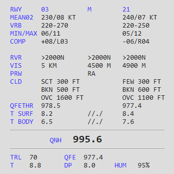
METSENSOR
Showing weather data in real time (updated every minute, or more frequently).
The data is displayed in three columns, below an example for ESGG:

The data is displayed in three separate columns, depending on which sensor the data is from.
METAR/TAF
Shows
SMHI
SWC NORDEN
VFR
SUN
DOCUMENTS
Access to Wiki/AIP and other operational information.
