ESPE - Vidsel
Overview
Vidsel air base is a military airport located 15 km west-northwest of the village of Vidsel. It is a critical part of Vidsel Test Range that provides an aerospace test and evaluation asset for Sweden through the Test & Evaluation (T&E) department of Swedish Defence Materiel Administration (FMV).
The base has one main runway (2230 m length) and three auxiliary runways (known as "short" runways, which are 800 m long), of which two are operational.
Airport Charts
AD Chart
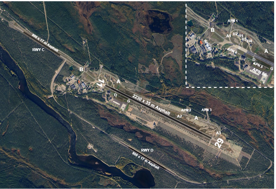
Parking stands
Available stands
Aprons
- APN 1-5 available for fast jets and smaller aircraft
- APN 86 for transport aircraft
- H1-H4 next to THR 11 for fast jets
Taxi
C130 not allowed to taxi between main RWY and short RWY C.
Take-off and climb
Contact Vidsel Approach when instructed by TWR.
On initial contact with Vidsel Approach report altitude to verify transponder Mode C readout.
MET information
As there is no ATIS, expect ATC to read the relevant weather information for arrival and departure.
Military traffic
Regulations
Military pilots should be familiar with Rules and Procedures for Military Aviation.
COM Channels
| Login Callsign | Radio Callsign | Frequency | MIL Channel |
|---|---|---|---|
| ESPE_APP | Vidsel Approach | 124.150 | C2 |
| ESPE_F_APP | Vidsel Approach | 119.200 | C |
| ESPE_P_APP | Vidsel Precision | 135.400 | B |
| ESPE_TWR | Vidsel Tower | 130.400 | A |
Expect the MIL channel designation to be used when getting a frequency change, for example:
CONTACT VIDSEL APPROACH CHANNEL CHARLIE TWO.
Instrument approach procedures
No civil instrument approach procedures published.
- RWY 29: ILS/LOC, MILS, TILS, PAR, SRE, VDF
- RWY 11: SRE
MIL instrument approach procedures
RWY 11
- Initial approach altitude 2900 ft
- Safety altitude:
- SRE 1650 ft
- MAP: straight ahead
- Safety altitude:
RWY 29
- Initial approach altitude 2600 ft
- Safety altitude:
- MILS 794 ft
- TILS 830 ft
- PAR 900 ft
- SRE 1200 ft
- VDF 1820 ft
- MAP: straight ahead to 3200 ft