ESPE - Vidsel
Overview
Luleå/KallaxVidsel air base is a joint civil-military airport whichlocated is15 homekm to the F 21 air wing. The civilian sidewest-northwest of the airportvillage of Vidsel. It is also relatively busy, with several airlines serving Stockholm/Arlanda on a dailycritical basis.part Thereof isVidsel alsoTest scheduledRange trafficthat toprovides Gothenburg,an aerospace test and seasonallyevaluation toasset Zurichfor Sweden through the Test & Evaluation (T&E) department of Swedish Defence Materiel Administration (FMV).
The base has one main runway (2230 m length) and Paris-Orly.
Atauxiliary almostrunways 3.4(known kilometres,as the"short" runwayrunways, atwhich Kallaxare is800 them longestlong), runwayof inwhich Sweden.two are operational.
Airport Charts
AD Chart
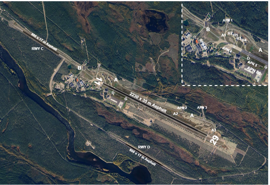
Parking stands
Available stands
Stand allocation - Who parks whereAprons
The airport website shows the real gate for each DEPARTING and ARRIVING flight.
Civil traffic
Civil aprons are on the north side of the runway:
Airline flights mainly use stand 3-5 (with air bridge) and 20-22 (remote stands).Cargo flights use Apron 11.GA on stand 7-8.Small GA on Apron 10.
Military traffic
Military aprons are on the south side of the runway:
- APN
1:1-5Helicoptersavailablee.g.forHKPfast14jets(NH90)and smaller aircraft - APN
2:86MILforjetstransporte.g. JAS 39 (SB39)aircraft APNH1-H43:nextMILto THR 11 for fast jetse.g. JAS 39 (SB39)APN 8: Transport aircraft e.g. C130, C17
IFR Clearance
ATC clearance will be delivered prior to/at start-up. Such clearance will be issued for RWY in use and appropriate SID.
If unable to follow FMS/RNAV SID, inform ATC when requesting clearance. Expect radar vectors.
Pushback
Pushback is normally required from stand and 3-8, 20 and 22.Power out from stands 20-22 and 7-9 is permitted for aircraft with MTOM 20 tonnes or less.Power out from stands 22, 7 and 8 is permitted for aircraft size RJ1H or smaller, provided the aircraft has been parked in order to allow taxiing out from the stand under own power.Power out from stand 20 is permitted for aircraft size A320 or smaller, proviced the aircraft has been parked in order to allow taxiing out from the stand under own power (normally facing north), and that stands 21-22 are free.
Use of transponder
The assigned transponder code shall be selected and the transponder activated at the request for push-back. After landing, the transponder shall remain activated until reaching the parking stand and be switched to standby immediately after parking.
Taxi
LargeC130 transportnot aircraft (C130, C17)allowed to MILtaxi APNbetween 8main shall use TWY ARWY and crossshort RWY via A3, U3.C.
Avoid back-track on RWY between April 15 and October 30 due to risk of surface damage.
APRON 9 (MAIN APRON) LIMITED (REF AIP SUP 277/25):
N entry to APN 9: max wingspan 52 m (code D)S entry to APN 9 (second entry counted from north): max wingspan 65 m (code E)
Take-off and climb
Contact KallaxVidsel Approach when instructed by TWR.
On initial contact with KallaxVidsel Approach report altitude to verify transponder Mode C readout.
If unable to follow FMS/RNAV SID, inform Kallax Approach on initial contact stating “unable RNAV SID.”
RNAV STAR
Advise if unable to follow RNAV STAR. Radar vectoring will be provided.
When cleared to a lower level or cleared for approach while on a STAR, minimum levels as published in the STAR must still be followed.
MET information
As there is no ATIS, expect ATC to read the relevant weather information for arrival and departure.
Military traffic
Regulations
Military pilots should be familiar with Rules and Procedures for Military Aviation.
COM Channels
| Login Callsign | Radio Callsign | Frequency | MIL Channel |
|---|---|---|---|
| C2 | |||
| C | |||
| B | |||
| A |
Expect the MIL channel designation to be used when getting a frequency change, for example:
CONTACT KALLAXVIDSEL APPROACH CHANNEL CHARLIE TWO.
Traffic circuit
RWY 14 right hand circuitRWY 32 left hand circuitCircuit altitude normally2000 ftTurn to base leg at or below1000 ft
Instrument approach procedures
No civil instrument approach procedures published.
- RWY 29: ILS/LOC, MILS, TILS, PAR, SRE, VDF
- RWY 11: SRE
MIL instrument approach procedures
RWY 1411
- Initial approach altitude
21002900 ft- Safety altitude:
MILS/TILS 270 ftPARSRE3301650 ftSRE560ft (based on MSSR)VDF760ft (with distance info) /960ft (without distance info)
- MAP: straight ahead
1.6 NM, right to track 145 to 5.4 NM from ARP.
- Safety altitude:
RWY 3229
- Initial approach altitude
21002600 ft - Safety altitude:
MILS/MILS 794 ft- TILS
220830 ft - PAR
250900 ft - SRE
5201200 ft(based on MSSR) - VDF
5801820 ft
- MAP: straight ahead
1.6 NM, lefttotrack3200300 to 5.4 NM from ARP.ft
Visual approach procedures
Normal procedure is viaVP Procedure("Victor Papa Procedure"):Commence the procedure at VP point (VP points are located at approx. 3 NM final for each RWY).Continue to overhead (ARP) at or above 2000 ft.Overhead ARP break left or right to enter traffic circuit at 2000 ft.Turn to base leg at or below 1000 ft.
Straight-in landing may be requested (i.e. joining circuit directly without passing overhead).
Departure procedures
Military jet aircraft are cleared via Standard Departure to 5000 ft.
After take-off the aircraft will climb straight ahead to a specified distance, and then turn to a track according to the table below.The traffic climbs to5000 ftunless otherwise instructed.After 5.4 NM on track, the aircraft will continue as per ATC clearance.The clearance limit is normally a training sector, VFR exit point (VMC), navaid or destination airport.