ENBR – Bergen Flesland
Overview
Bergen Airport Flesland is the airport of the 2nd biggest city in Norway and covers most of the population in the western side of Norway. The most popular routing is flying over the mountain to Norways main airport at Oslo, but short commuter routes to Stavanger, Bodø, Trondheim, Kristiansand and other cities in Norway are common too. Bergen airport is also serving several European routes to popular vacation routes and important routes to the big hubs in central Europe.
Available stands
Use of stands
| Area | Stands | Assigned to |
|---|---|---|
| Terminal | 15-20 28-32 |
Domestic flights |
| 23-32 | International schengen flights | |
| 23-27 | International non-schengen flights | |
| North Remote Apron | 41-46 | Passenger remote stands |
| 47-48 | Ambulance flights | |
| South Remote Apron | 1-11 | Cargo & passenger remote stands |
| 1 | ARC E+ aircraft | |
| Helicopter Terminal | 50-56 | Offshore helicopter flights |
| Technical Apron | Local VFR club, Airlift, Widerøe Hangar | |
| GA Apron | General Aviaton | |
| De-Ice Platform | 81-84 | Buisness Jets |
IFR clearance
Initial contact is with Clearance Delivery, reporting callsign, stand number, and latest ATIS identification letter and QNH. If unable to follow SID, please advise on initial contact.
Push-back
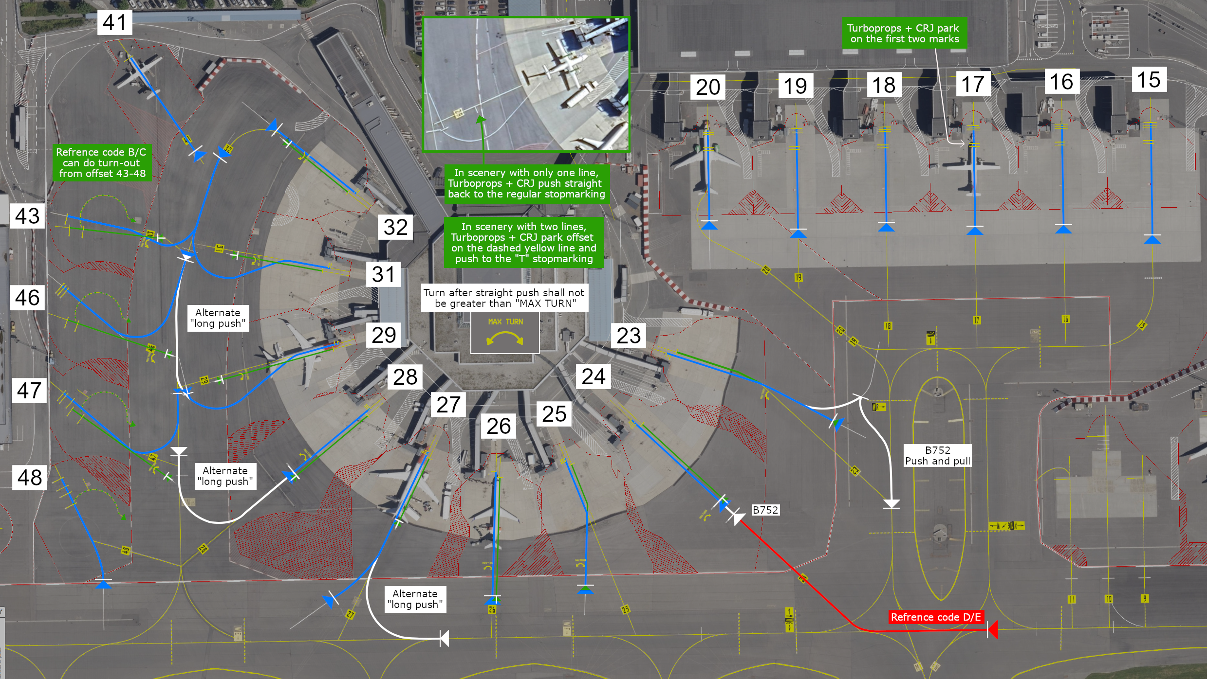
Most of the terminal gates require straight-back pushes. However, a few have turn pushes. In the map overview below, you will access all information:
Map Overviews
Terminal + Apron North (Stand 15-48)
Apron South (Stand 1-11)
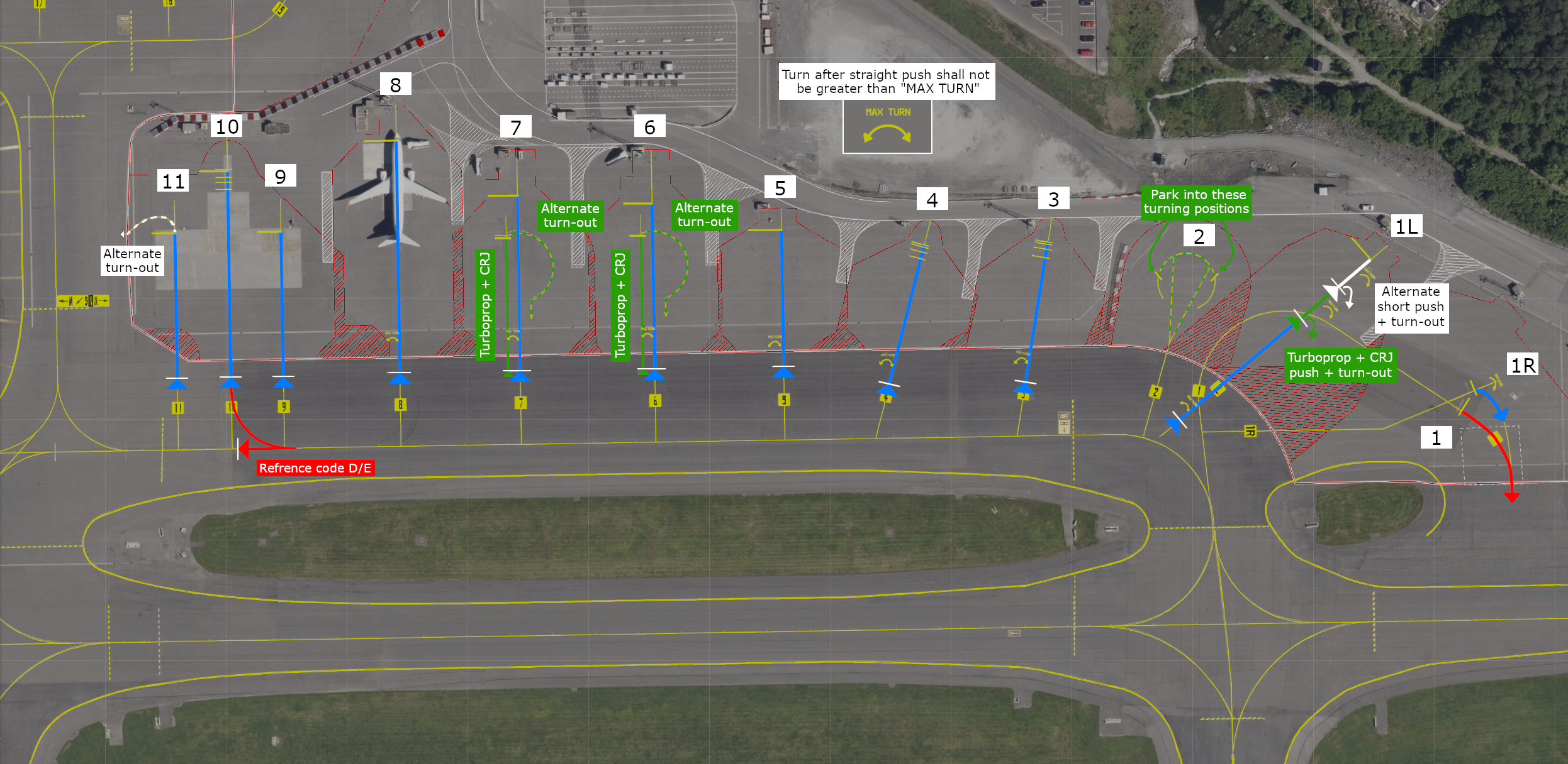
If the stand is not mentioned in the maps, ask the ground controller if you're unsure how to excecute the pushback
Taxi
Taxi instructions include the full taxi route, however the runway intersection will normally not be specified. Pilots are expected to taxi to the beginning of the runway; A1 (RWY 17) and A9 (RWY 35).
Aircraft with wake turbulence category light can expect taxi to interesection A2 (RWY 17) and A8 (RWY 35) during busy periods, and A4 (RWY 17) and A6 (RWY 35) when traffic permits.
Helicopters on Heli Apron can expect taxi to intersection A5 (RWY 17) and A6 (RWY 35).
Pilots are encouraged to state (preferably when on TWR frequency):
- Ready (or not ready) for departure, e.g.
READY [FOR DEPARTURE] (or NOT YET READY) - Acceptable or desired intersection for departure, e.g.
ABLE FROM A3 (or A2) (or [REQUIRE] FULL LENGHT)
Make sure to double-check if you are able to use the runway length from the intersection before requesting it.
Runways
There is a single runway available at ENBR, which is runway 17/35.
Helicopters may land on taxiway Y (parallel to the runway) if there are low traffic levels and good visibility conditions.
Please vacate the runway fully. This means the whole aircraft has crossed the stop bar line. If the aircraft is partly over and not fully, the consequences are that we might have to send aircraft around or delay them as the runway is not free.
SIDs
For all departures from Bergen, the initial climb is 6000ft, with the exception of helicopter SIDs. This initial climb altitude will always be included in your IFR clearance from ATC. It's crucial that you never climb above this initial altitude without ATC clearance, as STARs and SIDs intersect at various altitudes.
If you're unable to follow the published SIDs—perhaps due to an outdated AIRAC, a default aircraft, or freeware lacking a navigation database—you should request an Omni-directional departure. These are designated as OMNI3D and OMNI3C on the charts. While they might sound like standard SIDs, they are true omni-directional procedures. You'll find their details on the charts; they're not waypoint-dependent, so any aircraft can fly them regardless of its navigation database. Some aircrafts do allow you to select these departures in the FMS system, while others have to be flown with manual inputs.
Flesland automatically hands over departing aircraft after they pass 1500 feet. The ATIS will tell you who to contact.
- If ATIS reports "when passing 1500ft contact approach": Refer to your SID chart for the correct Approach frequency (either 121.0 or 126.1). Ignore any frequencies shown in your pilot client.
- If ATIS reports "when passing 1500ft contact Polaris Control frequency 123.456": Contact the provided Polaris Control frequency.
- If ATIS reports "when passing 1500ft monitor advisory 122.8": Switch to advisory frequency 122.8. This means there's no further ATC coverage.
If Tower tells you to "remain on my frequency," stay on the Tower frequency. This instruction is usually given when separation from other traffic isn't yet guaranteed. You must remain on Tower frequency until Tower explicitly tells you to contact the next sector.
Arrival and STARs
Before or at the initial phase of your descent, you will recessive your clearance for STAR and arrival. The arrivals contain many waypoints and restrictions. We recommend preloading the expected STAR and crosschecking so the correct fixes and restrictions have been loaded before descending. This helps you and the aircraft to plan the optimum descend profile and the start of the desende. Although remember to not start on the STAR unless you have been cleared by the controller.
Flesland is using a “Point Merge System”, or PMS. This means that all STARs end up in a “fan” made out of waypoints (RIVIP, GODID, GILVA, NEPAM), in which pilots should always be prepared for a direct routing towards the merge waypoint, 4 in total, in order to ease the workload of approach ATC.
Approach
Expect the ILS W approach at Bergen unless ATC/ATIS instructs otherwise.
The last fix of a STAR (or Merge Point) leads into a transition to the ILS approach for each runway. You are expected to fly the published transition. While ATC may issue vectors, particularly during high traffic periods, always be prepared to fly the transition and never fly direct from the merge point to the Final Approach Fix. If you don't have available transitions in your system, inform ATC and request vectors.
When you are cleared for the approach via GILVA, NEPAM, GODID or RIVIP transition, you are also cleared to continue the descent as long as the restrictions are followed. Usually, the restriction is 4000 feet or above at the transition point, but we recommend as always looking at your chart for the most precise information.
Following approach types is available in ENBR:
| Runway | Approach types |
|---|---|
| 17 | ILS W, LOC W, RNP Z, RNP (AR) E/N/S/W, VOR Helicopter only: ILS Y, LOC Y, RNP 139 |
| 35 | ILS W, LOC W, RNP Z, RNP (AR) E/N/W, VOR Helicopter only: ILS Y, LOC Y, RNP 043 |
1. RNP (AR) approaches should primarily be used outside of peak traffic times. RNP Z is available upon request.
2.Visual approaches are also an option. When flying a visual approach, do not descend below 2000 feet until established on final. Expect direct routing to specific points outlined in the visual approach chart when planning for these.
Direct routings
In Norway, direct routings are often used. Both arriving and departing traffic should be prepared to fly direct the end of SIDs, STAR Merge Points, and airspace border fixes. Make sure you have your filed route and waypoint page available to quickly accommodate direct routings.
Communications
You can always check online positions and sectors by visiting vatglasses.uk
ENBR_ATIS – Flesland ATIS – 125.255
ENBR_DEL – Flesland Delivery – 123.405
ENBR_P_GND - Flesland Ground Planner - 121.305
ENBR_GND – Flesland Ground – 121.905
ENBR_TWR – Flesland Tower – 119.105
ENBR_W_APP – Flesland Approach West – 121.005
ENBR_E_APP – Flesland Approach East – 126.105
ENBR_D_APP – Flesland Director – 118.855
ENSV_CTR – Polaris Control (Stavanger ACC) – 120.655
ENSV_N_CTR – Polaris Control (Stavanger ACC north) – 124.705
ENOR_CTR - Polaris Control (Bandbox) - 125.500
ENOR_S_CTR - Polaris Control (Bandbox South/Covering ENOS+ENSV AoR) - 121.550
ENOR_SC_CTR - Polaris Control (Bandbox South Central/Covering ENOS+ENSV+ENBD_S - 134.515
ENRC_S_CTR - Flesland Tower (Bodø Remote Tower Center) - 118.425