Procedural Approach
Akureyri Tower is unique within Iceland, in that it is the only TWR unit which also provides an approach control service within the Akureyri TMA.
Akureyri TMA
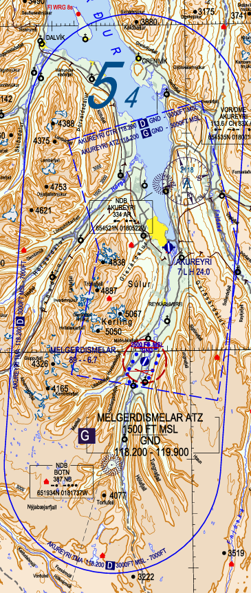
The Akureyri TMA has a lower limit of 3000ft and an upper limit of 7000ft. It overlies the Akureyri CTR, and is surrounded by the Class E airspace of Reykjavik ACC. It is Class D airspace.
In real life, outside of the operating hours of Akureyri Tower, the TMA reverts to Class E airspace and is controlled by Reykjavik ACC. However, on VATSIM, we simulate Akureyri Tower as being in operation whenever anyone is controlling the position, so for all intents and purposes the airspace is always Class D.
Primary Surveillance Radar (PSR)
Primary surveillance radar (PSR) is available within Akureyri TMA.
Akureyri TWR may use PSR to stay situationally aware of traffic in their airspace. However, Akureyri TWR shall at all times adhere to procedural separation minima, and may not vector aircraft or apply radar separation minima. The only exception is when Akureyri TWR is providing a surveillance radar approach service (LOC/ASR approach; see below.)
IFR Arrivals
Upon first contact, TWR shall give all aircraft the local QNH.
STAR/Initial Approach
Runway 19
Runway 19 at BIAR has published STARs. Reykjavik ACC clears aircraft onto the STAR and descends them to 7000ft, then transfers the aircraft to TWR prior to them commencing the STAR. Upon first contact, TWR will issue further descent to 6000ft.
There are some STARs with the same starting fix but different routings (e.g., MAMEP1M and MAMEP1N.) In these cases, the "M" STAR is preferred (i.e., MAMEP1M), as it connects directly to the ILS approach for RWY 19.
If Reykjavik is offline, then TWR may send a “contact me” to the aircraft before they reach the STAR's first waypoint. TWR may then issue clearance onto the STAR and descent to 6000ft. For example:
🎧 ICE200, Akureyri Tower, cleared AFPAC 1M arrival, descend 6000ft, QNH 1014.
Runway 01
Runway 01 has no published STARs. Therefore, aircraft generally proceed directly to the IAF for the instrument approaches — NB, GILTU, or PEXIL.
On first contact, aircraft should be descended to the initial approach altitude for their intended approach type and IAF, and given the local QNH. The initial approach altitudes for each IAF and approach are as follows:
|
BIAR RWY 01 Initial Approach Altitudes |
|||
|
|
Approach Type |
||
|
IAF |
ILS |
LOC |
LOC A |
|
NB |
6100’ |
6500’ |
|
|
GILTU |
— |
6800’ |
|
|
PEXIL |
6000’ |
— |
|
For more information on BIAR's approaches, see below.
Final Approach
As a general principle, to ensure procedural separation, only one aircraft may be on initial approach (between the IAF and being established on final approach) at once. In other words:
- If there is no traffic ahead on approach, TWR may clear aircraft onto the approach.
- If there is traffic ahead that is not yet established on final approach, then TWR must instruct further arrivals to hold.
- Only after the traffic ahead is established on final approach may TWR clear further aircraft onto the approach.
Approach clearance generally follow the format: Via [IAF], cleared [APPROACH] runway XX, report [established/final approach track]. For example:
🎧 ICE500, via NORFI, cleared ILS approach runway 19, report established.
🎧 ICE501, via GITTA, cleared RNP X approach runway 19, report established on final approach track.
Generally, "report established" is used for ILS approaches, "report established on final approach course" is used for LOC, VOR, and NDB approaches, and "report established on final approach track" is used for RNAV/RNP approaches.
Runway 19
There are two instrument approaches mainly used for runway 01: the ILS and the RNP X approaches. They are assigned depending on which STAR the aircraft is on:
- If the aircraft is on a STAR ending with the letter M, they should be cleared for the ILS approach.
- If the aircraft is on a STAR ending with the letter N, they should be cleared for the RNP X approach.
Runway 01
There are two main instrument approaches used for runway 01: the ILS and Localizer approaches.
The ILS approach is a straight-in ILS with a steep approach angle (5.3 degrees). In general, it is preferred; however, because of the steep approach angle, aircraft may occasionally require the Localizer approach.
The Localizer approaches into BIAR offer a less steep approach angle, but a lower precision and more challenging approach.
- Unlike most airports, BIAR’s localizer approach uses a different localizer beacon than the ILS approach. The localizer approach uses an offset localizer that follows the valley towards the airport, allowing for a less steep approach, but requiring a left turn on short final to line up with the runway.
- There are two localizer approaches – the LOC approach for aircraft categories A & B, and the LOC A approach for aircraft categories C & D.
- The two approaches are essentially identical in lateral routing, but the LOC approach (categories A/B aircraft) has a slightly less steep approach path. TWR is expected to clear aircraft onto the appropriate approach for their category.
NB/PEXIL are the IAFs for the ILS approach, and GILTU/NB are the IAFs for the LOC/LOC A approaches. Reykjavik Control will generally route aircraft directly to these fixes.
NOTE! The initial approach altitudes are subject to change, and are only provided here for reference. Always consult the current Iceland AIP for the most up-to-date approach altitudes.
Arrival Sequencing and Holding
If there are two or more arrivals at once, until the first aircraft has established onto the ILS/final approach track, no further aircraft may be cleared for approach. If the second aircraft reaches the IAF before the first aircraft is established onto final approach, the second aircraft must hold until the first aircraft is established.
The following IAFs have published holds: NORFI, ARLAX, and AKI. Their MHAs are:
- NORFI & ARLAX – 6000ft
- AKI – 5000ft
- NB – 6500ft
For aircraft approaching an IAF without a published hold (e.g., GITTA), TWR should re-route the aircraft to an IAF with a published hold to hold there. Aircraft should maintain at least 6000ft to ensure terrain clearance.
Published holds may be issued using the abbreviated phraseology: “Hold at [FIX] as published, [LEVEL].” For example:
🎧 ICE123, hold at ARLAX as published, 6000ft.
When issuing a non-published hold, or if a pilot requests the full details of the hold, the following information should be given at minimum:
- Holding fix
- Level
- Inbound track/course
The following may also be specified:
- Turn direction (left or right turns. If not specified, it is assumed that the holding shall use right turns.)
- Time/length of leg (in minutes or NM. If not specified, it is assumed that the holding shall use 1-minute legs.)
The following phraseology may be used: [CALLSIGN], hold at [FIX], [LEVEL], [INBOUND COURSE], [LEFT/RIGHT] turns, [LEG TIME/LENGTH]. For example:
🎧 ICE123, hold at NORFI as published, 6000ft, inbound course 159, right turns, one minute legs.
Because the MHA of all the holds are quite close to the upper limit of the TMA, combined with the small size of the TMA itself, there is a significant capacity constraint on the amount of aircraft Akureyri TWR may hold in the TMA at once.
If there is a substantial amount of arriving traffic (>4 in the TMA at once), TWR should coordinate with Reykjavik ACC to hold aircraft outside of the TMA.
Missed Approach
TWR should instruct aircraft to follow the standard missed approach. The standard missed approaches vary between runways and approaches, and should be strictly adhered to to maintain terrain clearance.
Once the aircraft has completed the missed approach procedure, they may be cleared direct to one of the approach IAFs to try the approach again.
If aircraft are unable to fly the standard missed, TWR should instruct the aircraft to perform a visual climb to an appropriate waypoint/beacon (e.g., AKI for RWY 01, or NB for RWY 19), climbing to 6000ft. The aircraft may then be cleared further direct to one of the IAFs.
Non-Standard Approaches
RNP Y / LOC Approaches (RWY 19)
These approaches for RWY 19 are very similar to the ILS approach, sharing the same IAFs and essentially the same lateral routing/vertical profile. They may thus be treated the same, simply substituting the appropriate phraseology (e.g., saying “RNP Y” or “Localizer” instead of “ILS.")
NDB Approach (RWY 19)
The NDB approach into BIAR is a “teardrop” procedure. The aircraft starts at AKI VOR, flies outbound, then makes a long right turn (>180 degrees) to fly inbound OE. After OE, the aircraft joins a short final for runway 19.
Aircraft on the NDB approach should be asked to report outbound from AKI, and then inbound OE. Once an aircraft is inbound OE, it is considered to be on final approach track, and further aircraft may be cleared for approach.
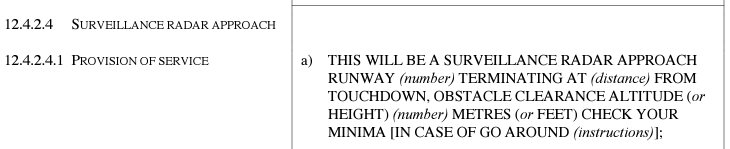
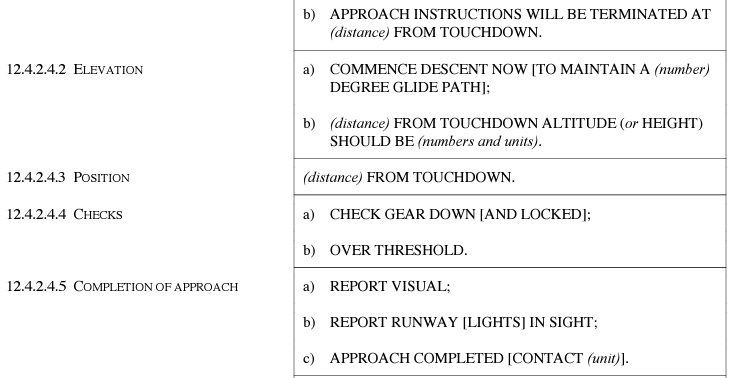
LOC/ASR Approach (RWY 01)
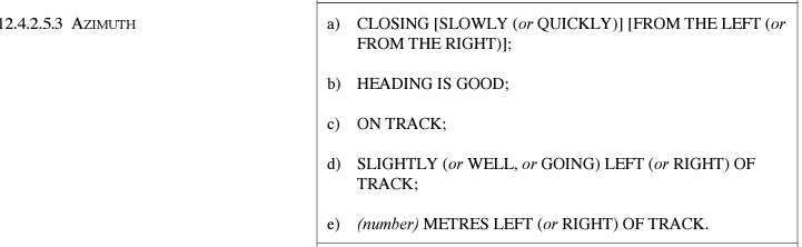
The LOC/ASR approach for runway 01 is a unique procedure which combines the offset localizer, which is used for initial approach, with a surveillance radar approach, which is used for the left turn to final. This is the only circumstance in which Akureyri Tower is authorized to issue instructions based on radar.
The procedure is as follows:
- Via NB or GILTU, the aircraft establishes onto the localizer, and descends like it would on a normal localizer approach.
- The aircraft shall report 12 DME out. At this point, TWR may radar identify the aircraft (i.e., look at their radar scope to determine which return corresponds to an aircraft 12 NM out from the localizer.)
- At 4.7 DME, TWR begins vectoring the aircraft, giving it heading instructions to line it up with the runway (starting with a heading of 007).
- TWR will instruct the aircraft not to acknowledge further transmissions from them.
- Starting from 4.0 DME, TWR will also provide pre-calculated advisory altitudes to the pilot.
- Once the aircraft is visual, the surveillance radar portion of the approach is completed, and the aircraft continues on a visual approach to the runway.
- If the aircraft has not reported visual by 2 DME, then they should be instructed to continue visually or go around.
When a LOC/ASR approach is in progress, TWR should be solely focused on issuing instructions to the aircraft on approach. Other aircraft should be instructed to hold, standby, etc. as appropriate.
Due to the complex nature of the approach, it is best demonstrated using an example:
🎧 ICE421, via GILTU, cleared LOC/ASR approach runway 19, report established on the localizer.
🧑✈️ Cleared LOC/ASR approach runway 19, wilco, ICE421.
…
🧑✈️ ICE421, established on the localizer.
🎧 ICE421, roger.
…
🧑✈️ ICE421, 12 DME.
🎧 ICE421, radar contact, this will be a surveillance radar approach for runway 01, terminating at 2 miles from touchdown, check your minima.
🧑✈️ Roger, ICE421.
🎧 ICE421, winds 330 degrees 10 knots, runway 01, cleared to land.
🧑✈️ Cleared to land, ICE421.
…
[Once the aircraft reaches 4.7 DME]
🎧 ICE421, turn left heading 007, report visual.
🧑✈️ Left heading 007, wilco, ICE421.
🎧 ICE421, do not acknowledge further transmissions.
…
🎧 ICE421, 4 miles from touchdown, altitude should be 1490 ft.
…
🎧 ICE421, 3.5 miles from touchdown, altitude should be 1310 ft.
…
🎧 ICE421, going left of track, turn left 2 degrees.
…
🎧 ICE421, closing slowly from the left, 3 miles from touchdown, altitude should be 1120 ft.
…
🎧 ICE421, turn right 2 degrees.
…
🎧 ICE421, on track, 2.5 miles from touchdown, altitude should be 940 ft.
…
🧑✈️ Visual, ICE421.
🎧 ICE421, on track 2 miles from touchdown, approach completed.
Some important phraseology to keep in mind when performing a LOC/ASR approach include the following (sourced from ICAO Doc 4444):
Departures
Generally, departures should be asked to report passing 7000ft, after which they may be transferred to Reykjavik Control. If the departure's flight path may cross the path of any arrivals, or if the flight path of the departure is not defined (e.g., it is on a visual climb), then TWR should hold arrivals until the departure has left the TMA.
VFR in the TMA
As Akureyri Tower is responsible for BIAR TMA, that means that Akureyri Tower is also responsible for VFR aircraft within the TMA.
VFR aircraft require clearance to enter the TMA. For example:
🎧 (TF-)ISN, cleared to enter the Akureyri TMA, 3500ft or below, QNH 1010.
BIAR TWR controllers are reminded that the TMA and the CTR are separate airspaces with different lateral and vertical boundaries. For example:
- Aircraft leaving the CTR below 3000ft will not enter the TMA, and therefore should be released to UNICOM as soon as they pass the CTR boundary.
- Similarly, aircraft crossing the TMA’s lateral boundaries below 3000ft are not within the TMA, and may remain on UNICOM until approaching the CTR (if inbound to BIAR.)
BIAR TWR controllers are also reminded that in Iceland, above 3500ft, VFR aircraft shall cruise at levels following the semi-circular rule (East = odd level, West = even level) plus 500ft.
- I.e., within the TMA, valid cruising levels for a VFR flight tracking Eastbound would be 3500ft or 5500ft, and valid cruising levels for a VFR flight tracking Westbound would be 4500ft or 6500ft.
The airspace surrounding the CTR (below 3000ft) is Class G (uncontrolled) airspace. Aircraft leaving the CTR without climbing above 3000ft should be instructed to monitor UNICOM.
The airspace surrounding the TMA (3000ft and above) is Class E airspace controlled by Reykjavik ACC. Reykjavik ACC may provide a flight information service upon request to VFR aircraft in this airspace, but is not required to do so.
- Hence, VFR aircraft leaving the TMA should be told “frequency change approved.” It is the pilot’s responsibility to either monitor UNICOM, or at their own discretion, change to the Reykjavik Control frequency to request FIS.